From Wikipedia, the free encyclopedia
Wikipedia list article
This is a list of Registered Historic Places in Smithfield , Rhode Island
This National Park Service list is complete through NPS recent listings posted February 2, 2022. [1]
[2] Name on the Register[3]
Image
Date listed[4]
Location
City or town
Description
1
Allenville Mill Storehouse
January 20, 1972 (#72000033 ) 5 Esmond St. 41°52′41″N 71°30′09″W / 41.878056°N 71.5025°W / 41.878056; -71.5025 (Allenville Mill Storehouse ) Smithfield
2
Angell–Ballou House
March 18, 2004 (#04000196 ) 49 Ridge Rd. 41°53′42″N 71°30′05″W / 41.895°N 71.501389°W / 41.895; -71.501389 (Angell–Ballou House ) Smithfield
3
Georgiaville Historic District
October 3, 1985 (#85002734 ) Roughly bounded by Stillwater Rd., Cross St., Whipple Ave., and Farnum Pike 41°53′18″N 71°30′26″W / 41.888333°N 71.507222°W / 41.888333; -71.507222 (Georgiaville Historic District ) Smithfield
4
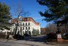
Saint Thomas Episcopal Church and Rectory
July 2, 1987 (#87000993 ) Putnam Pike 41°52′16″N 71°33′12″W / 41.871111°N 71.553333°W / 41.871111; -71.553333 (Saint Thomas Episcopal Church and Rectory ) Smithfield
5
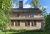
Smith–Appleby House
May 1, 1974 (#74000005 ) Stillwater Rd. southeast of its junction with Capron Rd. 41°54′07″N 71°31′06″W / 41.901944°N 71.518333°W / 41.901944; -71.518333 (Smith–Appleby House ) Smithfield
6
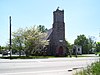
Smithfield Exchange Bank
April 19, 2006 (#06000295 ) 599 Putnam Pike 41°52′26″N 71°33′12″W / 41.873889°N 71.553333°W / 41.873889; -71.553333 (Smithfield Exchange Bank ) Smithfield
7
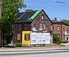
Ira B. Sweet House
January 15, 2010 (#08000715 ) 38 Esmond St. 41°52′31″N 71°30′13″W / 41.875369°N 71.503639°W / 41.875369; -71.503639 (Ira B. Sweet House ) Smithfield
8
Waterman–Winsor Farm
June 27, 1980 (#80000012 ) 79 Austin Ave. 41°52′55″N 71°33′45″W / 41.881944°N 71.5625°W / 41.881944; -71.5625 (Waterman–Winsor Farm ) Smithfield
9
Stephen Winsor House
October 6, 1975 (#75000004 ) 113 Austin Ave. 41°53′08″N 71°33′55″W / 41.885502°N 71.565378°W / 41.885502; -71.565378 (Stephen Winsor House ) Smithfield Listed at 93 Austin Ave.
10
Woonasquatucket River Site (RI-163)
November 1, 1984 (#84000364 ) near Farnum Pike[5] 41°54′33″N 71°32′21″W / 41.90924°N 71.539285°W / 41.90924; -71.539285 (Woonasquatucket River Site (RI-163) ) Smithfield
See also [ ] References [ ]
^ National Park Service, United States Department of the Interior , "National Register of Historic Places: Weekly List Actions" , retrieved February 2, 2022.
^ Numbers represent an alphabetical ordering by significant words. Various colorings, defined here , differentiate National Historic Landmarks and historic districts from other NRHP buildings, structures, sites or objects.
^ "National Register Information System" . National Register of Historic Places National Park Service . March 13, 2009.^ The eight-digit number below each date is the number assigned to each location in the National Register Information System database, which can be viewed by clicking the number.
^ "Smithfield Reconnaissance Report" (PDF) . National Park Service. Retrieved 2013-11-02 .
Topics Lists by county Lists by city
Bristol Coutny Kent County Newport County Providence County Washington County
Category NRHP portal Rhode Island portal
Categories :
Smithfield, Rhode Island Buildings and structures in Smithfield, Rhode Island National Register of Historic Places in Providence County, Rhode Island Lists of National Register of Historic Places in Rhode Island by city Lists of National Register of Historic Places by city Hidden categories:
Articles using NRISref without a reference number Articles with short description Short description is different from Wikidata Lists of coordinates Geographic coordinate lists Articles with Geo