National Register of Historic Places listings in St. Louis south and west of downtown
This is a list of properties and historic districts on the National Register of Historic Places within the city limits of St. Louis, Missouri, south of Interstate 64 and west of Downtown St. Louis. For listings in Downtown St. Louis, see National Register of Historic Places listings in Downtown and Downtown West St. Louis. For those north of I-64 and west of downtown, see National Register of Historic Places listings in St. Louis north and west of downtown. For listings in St. Louis County and outside the city limits of St. Louis, see National Register of Historic Places listings in St. Louis County, Missouri.
Current listings[]
| [1] | Name on the Register | Image | Date listed[2] | Location | Description |
|---|---|---|---|---|---|
| 1 |  |
January 31, 2017 (#100000609) |
3660 Market St. 38°37′53″N 90°14′16″W / 38.631519°N 90.237763°W |
||
| 2 |  |
January 29, 2013 (#12001243) |
4153–71 Bingham Ave. 38°35′18″N 90°15′39″W / 38.58833°N 90.26095°W |
||
| 3 |  |
February 2, 2016 (#15001019) |
1300 Hampton Ave. 38°37′36″N 90°17′16″W / 38.626576°N 90.287648°W |
||
| 4 | Anheuser-Busch Brewery |  |
November 13, 1966 (#66000945) |
721 Pestalozzi St. 38°35′51″N 90°12′44″W / 38.5975°N 90.212222°W |
|
| 5 |  |
July 21, 1983 (#83001042) |
3666 Flad Ave. 38°36′24″N 90°13′56″W / 38.606667°N 90.232222°W |
||
| 6 | September 2, 1982 (#82004731) |
2500–2630 Lafayette Ave. 38°36′54″N 90°13′16″W / 38.615°N 90.221111°W |
|||
| 7 |  |
December 30, 1985 (#85003232) |
Bounded by Gravois Ave., Interstate 55, S. Broadway, and Jefferson St. 38°35′52″N 90°13′09″W / 38.597778°N 90.219167°W |
||
| 8 |  |
July 31, 2013 (#13000568) |
4648–5003 Gravois Ave., 4719–4767 Morganford Rd. 38°34′54″N 90°16′01″W / 38.58178°N 90.266914°W |
||
| 9 |  |
July 21, 2015 (#15000442) |
3537 S. Kingshighway Blvd. 38°35′41″N 90°16′17″W / 38.5946°N 90.2713°W |
||
| 10 | Brown Shoe Company's Homes-Take Factory |  |
October 20, 1980 (#80004503) |
1201 Russell Boulevard 38°36′29″N 90°12′36″W / 38.608056°N 90.21°W |
Built in 1904 by St. Louis architects Weber and Groves, the Brown Shoe Company owned and operated the facility until the 1930s. The International Hat Company converted the building into a warehouse in 1954, until selling the property in 1976. In 1980, the building was converted into 100 apartments for assisted senior living. |
| 11 |  |
December 28, 2000 (#00001550) |
2610 Tennessee Ave. 38°36′32″N 90°14′16″W / 38.608889°N 90.237778°W |
||
| 12 |  |
January 19, 1984 (#84002620) |
2327–31 and 2333–35 Rutger St. 38°37′09″N 90°13′07″W / 38.619167°N 90.218611°W |
||
| 13 |  |
October 2, 2017 (#100001690) |
1956 Utah St. 38°35′40″N 90°13′13″W / 38.594459°N 90.220363°W |
||
| 14 |  |
May 29, 1980 (#80004554) |
122 E. Davis St. 38°32′36″N 90°15′47″W / 38.543283°N 90.263072°W |
part of the Carondelet, East of Broadway, St. Louis Multiple Resource Area (MRA) | |
| 15 | March 21, 2007 (#07000171) |
8221 Minnesota 38°32′48″N 90°15′50″W / 38.546667°N 90.263889°W |
|||
| 16 |  |
February 22, 2006 (#06000064) |
Roughly bounded by Koeln Ave., Loughborough Ave., S. Broadway and Alabama Ave.; also roughly bounded by Loughborough Ave., Holly Hills Ave., Idaho Ave., and S. Broadway; also bounded by Iron St., Minnesota Ave., Pennsylvania Ave., and Holly Hills Ave.; also roughly bounded by Bates St. on the north, Interstate 55 on the west, S. Broadway on the east, and Holly Hills Ave. on the south; also roughly bounded by S. Broadway, Pennsylvania Ave., Interstate 55, Bates St., and Delor St. 38°33′14″N 90°15′27″W / 38.553889°N 90.2575°W |
Additional sets of boundaries represent boundary increases of December 20, 2007, February 18, 2009, January 25, 2010, and July 14, 2011 | |
| 17 |  |
October 21, 2004 (#04001163) |
909 S. Taylor Ave. 38°37′52″N 90°15′44″W / 38.631111°N 90.262222°W |
||
| 18 | Chatillon-DeMenil House |  |
June 9, 1978 (#78001673) |
3352 DeMenil Pl. 38°35′32″N 90°12′57″W / 38.592222°N 90.215833°W |
|
| 19 |  |
August 12, 2010 (#10000538) |
3801-05 S. Broadway 38°35′09″N 90°13′40″W / 38.585833°N 90.227778°W |
part of the South St. Louis Historic Working and Middle Class Streetcar Suburbs Multiple Property Submission (MPS) | |
| 20 |  |
April 5, 2006 (#06000220) |
4030 Chouteau (also 1029 S. Vandeventer) 38°37′46″N 90°14′57″W / 38.629444°N 90.249167°W |
||
| 21 |  |
February 2, 2001 (#01000036) |
Roughly bounded by Lafayette Ave., Grattan St., Carroll St., Dillon St., St. Ange St., 14th St., and Carroll St. 38°36′50″N 90°12′28″W / 38.613889°N 90.207778°W |
||
| 22 |  |
April 30, 2008 (#08000359) |
8125 Michigan Ave. 38°32′45″N 90°15′57″W / 38.545708°N 90.265836°W |
||
| 23 |  |
June 3, 2019 (#100004006) |
3419 Papin St. 38°37′35″N 90°13′59″W / 38.6263°N 90.2330°W |
||
| 24 | Compton Hill Water Tower | 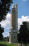 |
September 29, 1972 (#72001555) |
Reservoir Park, Grant and Russell Boulevards, and Lafayette Ave. 38°36′51″N 90°14′19″W / 38.614167°N 90.238611°W |
|
| 25 |  |
February 28, 1980 (#80004505) |
6400 Minnesota Ave. 38°33′23″N 90°15′00″W / 38.556389°N 90.25°W |
||
| 26 |  |
July 7, 1983 (#83001044) |
3401 Arsenal, 3400 and 3500 blocks of Crittenden 38°36′12″N 90°14′24″W / 38.603333°N 90.24°W |
||
| 27 |  |
December 23, 2004 (#04001385) |
6138 Virginia Ave. 38°33′44″N 90°15′00″W / 38.562222°N 90.25°W |
part of the St. Louis Public Schools of William B. Ittner MPS | |
| 28 |  |
September 2, 1982 (#82004735) |
6307 Michigan Ave. 38°33′32″N 90°15′00″W / 38.558889°N 90.25°W |
||
| 29 |  |
December 30, 1999 (#99001616) |
3115 S. Grand Boulevard 38°36′14″N 90°14′33″W / 38.603889°N 90.2425°W |
||
| 30 |  |
January 19, 1984 (#84002629) |
1424–1434 Dolman St. 38°36′56″N 90°12′36″W / 38.615556°N 90.21°W |
||
| 31 |  |
April 24, 2017 (#100000911) |
1215–23 S. Jefferson Ave. 38°37′12″N 90°13′10″W / 38.620036°N 90.219557°W |
||
| 32 |  |
September 1, 2015 (#15000555) |
Bounded by S. Grand Blvd., Delor & Liberty Sts., Alabama, Virginia & Bingham Aves. 38°34′29″N 90°14′44″W / 38.5746°N 90.2456°W |
||
| 33 | January 12, 2022 (#100007353) |
3417 Grace Ave. 38°35′45″N 90°14′41″W / 38.5957°N 90.2448°W |
|||
| 34 | Forest Park Southeast Historic District |  |
December 20, 2001 (#01001360) |
Roughly bounded by Chouteau Ave., Manchester and Cadet Aves., Kingshighway Boulevard, and S. Sarah St.; also 4170–4370 and 4229–4341 Manchester Ave.; also 4121–25, 4127–29, 4131, 4133, 4137, 4139–41, 4143, 4145, 4501–07, 4509–11, 4510, and 4512–14 Manchester Ave.; also 4100–4162 and 4151–4201 Manchester, and 4216 Gibson; also portions of Boyle, Chouteau, Kentucky, Norfolk, Swawn, Talmadge, Tower Grove, Vandeventer, and Vista 38°37′43″N 90°15′33″W / 38.628611°N 90.259167°W |
Additional sets of boundaries represent boundary increases of June 16, 2005, February 7, 2007, August 5, 2009, and December 19, 2012 |
| 35 |  |
September 16, 2009 (#09000719) |
Roughly bounded by Bates St., Grand Boulevard, Interstate 55, Alaska Ave., and Fillmore and Iron Sts. 38°33′53″N 90°15′08″W / 38.564711°N 90.252092°W |
||
| 36 |  |
December 15, 2015 (#15000896) |
Bounded by S. Grand Blvd., Bates St. & alleys W. of Dewey Ave. & S. of Bowen St. 38°34′03″N 90°15′31″W / 38.567595°N 90.258678°W |
||
| 37 |  |
February 14, 2006 (#06000037) |
3009 Pennsylvania Ave. 38°36′07″N 90°13′55″W / 38.602048°N 90.232045°W |
||
| 38 |  |
April 19, 2016 (#16000184) |
1615 Hampton Ave. 38°37′22″N 90°17′20″W / 38.622653°N 90.288778°W |
||
| 39 |  |
May 11, 2005 (#05000115) |
Gravois and S. Jefferson, S. Jefferson and S. Broadway, Meramac, S. Gran and Gravois; also 2644–54 Gravois Ave. 38°35′28″N 90°14′03″W / 38.591111°N 90.234167°W |
part of the South St. Louis Historic Working and Middle Class Streetcar Suburbs MPS; second set of addresses represents a boundary increase July 15, 2016 | |
| 40 |  |
February 26, 1987 (#87000508) |
139 Victor St. 38°35′58″N 90°12′04″W / 38.599444°N 90.201111°W |
||
| 41 |  |
January 14, 2014 (#13001088) |
3150 S. Grand Blvd. 38°36′04″N 90°14′32″W / 38.601113°N 90.242131°W |
||
| 42 | Harris Teachers College |  |
August 4, 2004 (#04000787) |
1517 South Theresa 38°37′19″N 90°14′13″W / 38.6219°N 90.2369°W |
part of the St. Louis Public Schools of William B. Ittner MPS |
| 43 |  |
January 18, 1985 (#85000107) |
Bounded roughly by Lasalle, Missouri, Rutger, and Jefferson Sts., and along Hickory St. 38°37′12″N 90°13′03″W / 38.62°N 90.2175°W |
||
| 44 |  |
March 22, 2016 (#16000102) |
Bounded by Holly Hills Blvd., MPRR, alley N. of Dover Pl., Leona St. & Ray Ave. 38°34′06″N 90°16′04″W / 38.5682°N 90.2678°W |
||
| 45 |  |
November 9, 2015 (#15000773) |
4431 S. Broadway 38°34′30″N 90°14′07″W / 38.5751°N 90.2352°W |
||
| 46 |  |
June 17, 2019 (#100004062) |
5850 Elizabeth Ave. 38°36′54″N 90°17′07″W / 38.6149°N 90.2854°W |
||
| 47 | Immaculate Conception Church and Rectory |  |
February 19, 2008 (#08000031) |
3120 Lafayette Ave. 38°37′04″N 90°14′32″W / 38.6178°N 90.2422°W |
|
| 48 |  |
May 8, 1985 (#85000995) |
2912 Lafayette 38°36′55″N 90°13′41″W / 38.6153°N 90.2281°W |
||
| 49 |  |
July 14, 2015 (#15000419) |
1 Jefferson Barracks Dr. 38°29′38″N 90°16′58″W / 38.4939°N 90.2828°W |
||
| 50 |  |
July 20, 2020 (#100005349) |
3701–3835 South Kingshighway Blvd. 38°35′32″N 90°16′22″W / 38.5922°N 90.2727°W |
||
| 51 |  |
February 7, 2007 (#07000023) |
Bounded by Ohio, Sidney and Victor Sts., and alley east of Texas Ave. (2500 Ohio Ave). 38°36′28″N 90°13′28″W / 38.607778°N 90.224444°W |
As of 2012, part of the St. Francis de Sales Historic District. | |
| 52 |  |
February 8, 2007 (#07000020) |
4401 Chouteau Ave. 38°37′49″N 90°15′31″W / 38.6303°N 90.2586°W |
||
| 53 |  |
October 13, 2011 (#11000737) |
2710–2716 Lafayette 38°36′54″N 90°13′26″W / 38.615°N 90.2239°W |
part of the Auto-Related Resources of St. Louis, Missouri MPS | |
| 54 | Lafayette Square Historic District |  |
June 28, 1972 (#72001557) |
Roughly bounded by Hickory and 18th Sts., Jefferson and Lafayette Aves.; also roughly bounded by Chouteau Ave., Dolman, Lafayette Ave., S. 18th St., Vail Pl., and McKay Pl. 38°37′00″N 90°12′55″W / 38.6167°N 90.2153°W |
Second set of boundaries represents a boundary increase of July 24, 1986 |
| 55 |  |
August 12, 1987 (#87001361) |
1054 S. Kingshighway Boulevard 38°37′47″N 90°15′49″W / 38.6297°N 90.2636°W |
||
| 56 |  |
June 18, 2009 (#09000441) |
Roughly bounded by Vandeventer, Park, Thurman, and Lafayette Aves. 38°37′12″N 90°15′12″W / 38.62°N 90.2533°W |
||
| 57 |  |
May 6, 2005 (#05000371) |
3815 McCausland Ave. 38°35′46″N 90°18′45″W / 38.5962°N 90.3125°W |
||
| 58 | March 5, 1992 (#92000079) |
3407 Lafayette Avenue 38°37′01″N 90°14′07″W / 38.6170°N 90.2352°W |
|||
| 59 | October 7, 2021 (#100007042) |
3535 South Jefferson Ave. (primary); 3519-59 South Jefferson Ave., 2611-19 Miami St. 38°35′27″N 90°13′34″W / 38.5908°N 90.2261°W |
|||
| 60 | September 2, 1992 (#92001095) |
4047 Juniata 38°36′08″N 90°15′16″W / 38.6022°N 90.2544°W |
part of the St. Louis Public Schools of William B. Ittner MPS | ||
| 61 | Marine Villa Neighborhood Historic District |  |
December 18, 2009 (#09001099) |
Roughly bounded by S. Broadway, Chippewa, Cahokia, Kosciusko, and Winnebago 38°35′12″N 90°13′24″W / 38.5866°N 90.2233°W |
part of the South St. Louis Historic Working and Middle Class Streetcar Suburbs MPS |
| 62 |  |
September 7, 1984 (#84002655) |
Roughly bounded by 18th St., Interstate 44, and Jefferson and Gravois Aves. 38°36′33″N 90°13′06″W / 38.6092°N 90.2183°W |
||
| 63 |  |
May 9, 2002 (#02000471) |
3218 Osceola St. 38°34′43″N 90°14′28″W / 38.578611°N 90.241111°W |
||
| 64 | Missouri Botanical Gardens |  |
November 19, 1971 (#71001065) |
2345 Tower Grove Ave. 38°36′45″N 90°15′33″W / 38.6125°N 90.259167°W |
|
| 65 |  |
March 28, 2002 (#02000270) |
1141–1151 S. 7th St. 38°36′57″N 90°11′48″W / 38.615733°N 90.196777°W |
||
| 66 |  |
May 2, 1985 (#85000943) |
4528 Nebraska Ave. 38°34′24″N 90°14′12″W / 38.573342°N 90.236616°W |
||
| 67 |  |
November 5, 2009 (#09000889) |
4230 Gravois Ave. 38°35′18″N 90°15′30″W / 38.588233°N 90.258408°W |
||
| 68 |  |
May 16, 2008 (#08000404) |
1400 S. 3rd St. 38°36′48″N 90°11′39″W / 38.613403°N 90.194028°W |
||
| 69 |  |
January 10, 2011 (#10001120) |
Roughly bounded by Gustine St, Arsenal St, alley west of Portis Ave, Humphrey St 38°36′06″N 90°15′30″W / 38.601667°N 90.258333°W |
||
| 70 |  |
June 13, 2008 (#08000508) |
1014–1038 Oakview Pl. 38°37′49″N 90°17′06″W / 38.630283°N 90.285044°W |
||
| 71 |  |
August 1, 2008 (#08000749) |
3542–48 S. Broadway 38°35′24″N 90°13′05″W / 38.589889°N 90.218167°W |
||
| 72 |  |
May 29, 1980 (#80004515) |
7827 Reilly St. 38°32′37″N 90°15′27″W / 38.543653°N 90.257511°W |
part of the Carondelet, East of Broadway, St. Louis MRA | |
| 73 |  |
July 19, 2006 (#06000628) |
3301 and 3305 Park Ave. 38°37′19″N 90°13′59″W / 38.621944°N 90.233056°W |
||
| 74 | Pevely Dairy Company Plant | November 18, 2009 (#09000937) |
1001 S. Grand, 3626 Chouteau, and 1101 Motard 38°37′31″N 90°14′15″W / 38.625308°N 90.237561°W |
Demolished in February 2012.[3] | |
| 75 |  |
March 31, 2010 (#10000117) |
2857 Lafayette Ave. 38°36′57″N 90°13′39″W / 38.615867°N 90.227558°W |
part of the South St. Louis Historic Working and Middle Class Streetcar Suburbs MPS | |
| 76 | Quinn Chapel AME Church |  |
October 16, 1974 (#74002277) |
227 Bowen St. 38°33′32″N 90°14′51″W / 38.558889°N 90.2475°W |
|
| 77 |  |
March 12, 2012 (#12000100) |
Roughly bounded by Arsenal St., Kingshighway Blvd., Southwest Ave. and the alley east of Hereford St. 38°36′32″N 90°16′14″W / 38.608822°N 90.27052°W |
||
| 78 |  |
May 14, 2004 (#04000428) |
5145–5149 Shaw Ave. 38°37′12″N 90°16′19″W / 38.62°N 90.271944°W |
||
| 79 | Roberts, Johnson and Rand-International Shoe Company Complex |  |
August 23, 1984 (#84002670) |
Mississippi and Hickory Sts. 38°37′10″N 90°12′47″W / 38.619444°N 90.213056°W |
|
| 80 |  |
September 2, 1992 (#92001097) |
3974 Sarpy Ave. 38°37′50″N 90°14′46″W / 38.630556°N 90.246111°W |
part of the St. Louis Public Schools of William B. Ittner MPS | |
| 81 |  |
May 9, 2002 (#01000948) |
Roughly bounded by Koeln and Tesson Sts., Broadway, and Alabama Ave. 38°32′59″N 90°15′41″W / 38.549722°N 90.261389°W |
||
| 82 |  |
January 8, 2009 (#08001286) |
Bounded by S. Grand Boulevard, Delor St., Virginia Ave., and Bates St. 38°34′09″N 90°14′58″W / 38.569125°N 90.249361°W |
part of the South St. Louis Historic Working and Middle Class Streetcar Suburbs MPS | |
| 83 | St. Francis de Sales' Church |  |
November 2, 1978 (#78003393) |
2653 Ohio St. 38°36′15″N 90°13′33″W / 38.604167°N 90.225833°W |
|
| 84 |  |
November 28, 2012 (#12000979) |
Bounded by Nebraska, Jefferson, & Victor Aves., Gravois Rd., & Pestalozzi St. 38°36′15″N 90°13′33″W / 38.604167°N 90.225833°W |
||
| 85 | St. John Nepomuk Parish Historic District |  |
June 19, 1972 (#72001558) |
11th and 12th Sts. between Carroll St. and Lafayette Ave. 38°36′45″N 90°12′17″W / 38.6125°N 90.204722°W |
part of the LaSalle Park MRA |
| 86 |  |
January 17, 1975 (#75002139) |
2nd and Arsenal Sts. 38°35′38″N 90°12′32″W / 38.593848°N 90.209021°W |
||
| 87 |  |
January 26, 2005 (#04001559) |
1000 block of Sanford Ave. 38°37′50″N 90°17′42″W / 38.630556°N 90.295°W |
||
| 88 |  |
May 29, 1980 (#80004516) |
8402 Vulcan St. 38°32′25″N 90°15′44″W / 38.540256°N 90.262353°W |
part of the Carondelet, East of Broadway, St. Louis MRA | |
| 89 |  |
January 27, 1999 (#98001600) |
7727 S. Broadway 38°32′47″N 90°15′33″W / 38.546389°N 90.259167°W |
Originally listed 1992 at 8000 Alaska St., delisted December 19, 1994 | |
| 90 |  |
September 28, 1984 (#84002683) |
1976–1982 Arsenal St. 38°35′52″N 90°13′13″W / 38.597778°N 90.220278°W |
||
| 91 |  |
March 22, 1984 (#84002685) |
2800 S. Grand Ave. 38°36′21″N 90°14′29″W / 38.605833°N 90.241389°W |
||
| 92 |  |
April 12, 1982 (#82004741) |
Roughly bounded by De Tanty St. and S. Spring, Shaw, and S. Grand Aves. 38°36′57″N 90°14′30″W / 38.615833°N 90.241667°W |
||
| 93 |  |
April 16, 2012 (#12000207) |
Roughly bounded by DeTonty, Tower Grove, Shaw, Alfred, Magnolia, Kingshighway, & Vandeventer Aves. 38°36′47″N 90°15′40″W / 38.613182°N 90.26119°W |
||
| 94 |  |
December 26, 1972 (#72001559) |
Roughly bounded by 7th Boulevard and Soulard, Lynch, and 12th Sts. 38°36′20″N 90°12′27″W / 38.605556°N 90.2075°W |
||
| 95 |  |
August 19, 1983 (#83004515) |
Roughly bounded by Soulard, 8th, 12th, and LaSalle Sts. 38°36′49″N 90°12′02″W / 38.613686°N 90.200433°W |
part of the LaSalle Park MRA | |
| 96 |  |
January 3, 2003 (#00001010) |
3606 Gravois Ave. 38°35′31″N 90°14′38″W / 38.591944°N 90.243889°W |
||
| 97 |  |
August 15, 1983 (#83004516) |
Roughly bounded by S. 11th, Park, Rutger, and S. 12th Sts. 38°36′53″N 90°12′11″W / 38.614844°N 90.203°W |
part of the LaSalle Park MRA | |
| 98 | Steelcote Manufacturing Company Paint Factory |  |
June 27, 2007 (#07000620) |
801 Edwin 38°37′43″N 90°14′02″W / 38.628611°N 90.233889°W |
|
| 99 |  |
May 29, 1980 (#80004514) |
Steins St. 38°32′49″N 90°15′26″W / 38.546904°N 90.257123°W |
part of the Carondelet, East of Broadway, St. Louis MRA | |
| 100 |  |
May 29, 1980 (#80004517) |
7600 Reilly St. 38°32′43″N 90°15′17″W / 38.545333°N 90.254847°W |
part of the Carondelet, East of Broadway, St. Louis MRA | |
| 101 |  |
November 9, 2018 (#100003089) |
3400 Russell Blvd. 38°36′46″N 90°14′10″W / 38.6129°N 90.2362°W |
||
| 102 |  |
March 27, 1980 (#80004511) |
200–204 Stein St. 38°32′53″N 90°15′32″W / 38.548056°N 90.258889°W |
||
| 103 |  |
May 5, 2000 (#00000440) |
4527 Virginia Ave, 3301 Taft Ave., and 4526 Idaho Ave. 38°34′29″N 90°14′34″W / 38.574722°N 90.242778°W |
||
| 104 |  |
March 27, 1980 (#80004512) |
2302–2306 S. Grand St. 38°36′35″N 90°14′25″W / 38.609722°N 90.240278°W |
||
| 105 | Sugar Loaf Mound |  |
February 17, 1984 (#84002689) |
4420 Ohio St.[4] 38°34′30″N 90°13′52″W / 38.575°N 90.231111°W |
|
| 106 |  |
July 23, 2013 (#13000537) |
2232 Thurman Ave. 38°36′40″N 90°15′04″W / 38.611229°N 90.251153°W |
||
| 107 |  |
February 10, 1983 (#83001052) |
Roughly bounded by 39th St., Lafayette Ave., Vandeventer Ave. and Folsom Ave. 38°37′07″N 90°14′31″W / 38.618611°N 90.241944°W |
Boundaries reflect changes made by boundary increases of July 26, 1985 and February 26, 1987 and modified by a boundary decrease of June 18, 2009 | |
| 108 |  |
March 27, 2013 (#13000114) |
Roughly bounded by S. Grand, Louisiana, Nebraska, Gravois & Shenandoah Aves. 38°36′11″N 90°14′10″W / 38.603054°N 90.236213°W |
||
| 109 |  |
September 6, 2001 (#01000947) |
Bounded by Arsenal St., Grand Blvd., McDonald Ave., and Gustine Ave.; also roughly bounded by Magnolia Ave., Louisiana Ave., Cherokee St., Gravois Ave., and Grand Blvd. 38°36′01″N 90°14′46″W / 38.600278°N 90.246111°W |
Second set of boundaries represents a boundary increase of April 16, 2004 | |
| 110 | Tower Grove Park |  |
March 17, 1972 (#72001556) |
Bounded by Magnolia Ave. on the north, Grand Boulevard on the east, Arsenel St. on the south, and Kings Highway Boulevard on the west 38°36′22″N 90°15′16″W / 38.606111°N 90.254444°W |
|
| 111 |  |
September 15, 2005 (#05001034) |
1520 S. Grand Ave. 38°37′18″N 90°14′17″W / 38.621667°N 90.238056°W |
||
| 112 |  |
January 26, 2006 (#05001549) |
2727 S. Jefferson Ave. 38°36′19″N 90°13′25″W / 38.605278°N 90.223611°W |
part of the South St. Louis Historic Working and Middle Class Streetcar Suburbs MPS | |
| 113 | Wachter Motor Car Company Building | May 24, 2007 (#07000463) |
2600–2614 Nebraska Ave. 38°36′30″N 90°13′45″W / 38.608333°N 90.229167°W |
part of the Auto-Related Resources of St. Louis, Missouri MPS | |
| 114 | November 13, 2018 (#100003086) |
7212 Arsenal St. 38°36′35″N 90°18′47″W / 38.6096°N 90.3131°W |
|||
| 115 |  |
April 28, 2015 (#15000174) |
1519 Tower Grove Ave. 38°37′22″N 90°15′22″W / 38.6227°N 90.2561°W |
||
| 116 |  |
September 2, 1992 (#92001096) |
1547 S. Teresa 38°37′08″N 90°14′12″W / 38.618889°N 90.236667°W |
part of the St. Louis Public Schools of William B. Ittner MPS | |
| 117 |  |
May 29, 1980 (#80004518) |
7707–7713 Vulcan St. 38°32′43″N 90°15′26″W / 38.545197°N 90.257161°W |
part of the Carondelet, East of Broadway, St. Louis MRA |

Former listings[]
| [1] | Name on the Register | Image | Date listed | Date removed | Location | Description |
|---|---|---|---|---|---|---|
| 1 |  |
March 1, 1982 (#82004736) | December 19, 1994 | 706 Chestnut St. |
Demolished in 1983.[5] | |
| 2 | August 1, 1986 (#86002088) | December 19, 1994 | 3863 W. Pine and 200 N. Vandeventer |
Demolished in 1993.[5] | ||
| 3 | Unitarian Church of the Messiah |  |
September 22, 1980 (#80004513) | December 19, 1994 | Locust and Garrison Sts. |
Demolished in 1987 following damage from a 1982 fire.[5] |
References[]
- ^ a b Numbers represent an alphabetical ordering by significant words. Various colorings, defined here, differentiate National Historic Landmarks and historic districts from other NRHP buildings, structures, sites or objects.
- ^ The eight-digit number below each date is the number assigned to each location in the National Register Information System database, which can be viewed by clicking the number.
- ^ "A year later, still no construction at Pevely site".
- ^ Location derived from Interest abounds in Sugar Loaf Mound, St. Louis Post-Dispatch, 2009-06-17. Accessed 2010-07-05. The NRIS lists the site as "Address Restricted".
- ^ a b c "Archived copy". Archived from the original on 2012-11-21. Retrieved 2012-12-15.
{{cite web}}: CS1 maint: archived copy as title (link)
| Topics | |
|---|---|
| Lists by state |
|
| Lists by insular areas | |
| Lists by associated state | |
| Other areas | |
| Related | |
| |
| |
|
Categories:
- History of St. Louis
- Lists of National Register of Historic Places in St. Louis
- St. Louis-related lists