National Register of Historic Places listings in Val Verde County, Texas

Location of Val Verde County in Texas
This is a list of the National Register Historic Places in Val Verde County, Texas
This is intended to be a complete list of properties and districts listed on the National Register of Historic Places in Val Verde County, Texas. There are seven districts and four individual properties listed on the National Register in the county. These include one National Historic Landmark District, one State Historic Site, one State Antiquities Landmark, and one Recorded Texas Historic Landmark.
- This National Park Service list is complete through NPS recent listings posted February 11, 2022.[1]
Current listings[]
The publicly disclosed locations of National Register properties and districts may be seen in a mapping service provided.[2]
| [3] | Name on the Register[4] | Image | Date listed[5] | Location | City or town | Description |
|---|---|---|---|---|---|---|
| 1 | September 4, 1986 (#86002188) |
Corner of Pecan and Academy Sts. 29°21′13″N 100°53′48″W / 29.353611°N 100.896736°W | Del Rio | Recorded Texas Historic Landmark | ||
| 2 | July 11, 2003 (#03000664) |
Roughly bounded by W 2nd St., Johnson Blvd., and St. Peter's St. 29°21′43″N 100°55′00″W / 29.361944°N 100.916667°W | Del Rio | |||
| 3 | 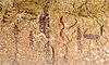 |
January 13, 2021 (#100006256) |
Lower Pecos River watershed area Coordinates missing | Comstock | Thirty-five mostly discontiguous rock art and other archeological sites; also listed in part in several other listings in this county, including Seminole Canyon Archeological District, , Mile Canyon, and the . | |
| 4 |  |
March 31, 1971 (#71000966) |
Address restricted[6] | Comstock | ||
| 5 | Mile Canyon |  |
October 15, 1970 (#70000773) |
Just downstream from Langtry 29°48′35″N 101°33′01″W / 29.8097°N 101.5502°W | Langtry | Also known as Eagle Nest Canyon |
| 6 | |
September 28, 1971 (#71000968) |
Address restricted[6] | Langtry | ||
| 7 | |
October 16, 1974 (#74002096) |
Address restricted[6] | Del Rio | ||
| 8 | Seminole Canyon Archeological District | 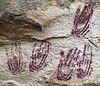 |
January 25, 1971 (#71000967) |
Between US 90 and the Rio Grande west of Comstock 29°41′00″N 101°19′06″W / 29.6833°N 101.3183°W | Comstock | State Historic Site |
| 9 | |
November 16, 1990 (#90001733) |
Address restricted[6] | Comstock | ||
| 10 | 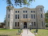 |
August 18, 1977 (#77001478) |
400 Pecan St. 29°21′32″N 100°53′50″W / 29.358889°N 100.897222°W | Del Rio | State Antiquities Landmark | |
| 11 | |
April 3, 1973 (#73001982) |
Address restricted[6] | Comstock |

See also[]
- National Register of Historic Places listings in Texas
- List of Texas State Historic Sites
- Recorded Texas Historic Landmarks in Val Verde County
References[]
- ^ National Park Service, United States Department of the Interior, "National Register of Historic Places: Weekly List Actions", retrieved February 11, 2022.
- ^ The latitude and longitude information provided in this table was derived originally from the National Register Information System, which has been found to be fairly accurate for about 99% of listings. Some locations in this table may have been corrected to current GPS standards.
- ^ Numbers represent an alphabetical ordering by significant words. Various colorings, defined here, differentiate National Historic Landmarks and historic districts from other NRHP buildings, structures, sites or objects.
- ^ "National Register Information System". National Register of Historic Places. National Park Service. April 24, 2008.
- ^ The eight-digit number below each date is the number assigned to each location in the National Register Information System database, which can be viewed by clicking the number.
- ^ a b c d e Federal and state laws and practices restrict general public access to information regarding the specific location of this resource. In some cases, this is to protect archeological sites from vandalism, while in other cases it is restricted at the request of the owner. See: Knoerl, John; Miller, Diane; Shrimpton, Rebecca H. (1990), Guidelines for Restricting Information about Historic and Prehistoric Resources, National Register Bulletin, National Park Service, U.S. Department of the Interior, OCLC 20706997.
External links[]
![]() Media related to National Register of Historic Places in Val Verde County, Texas at Wikimedia Commons
Media related to National Register of Historic Places in Val Verde County, Texas at Wikimedia Commons


Categories:
- Val Verde County, Texas
- Lists of National Register of Historic Places in Texas by county
- National Register of Historic Places in Val Verde County, Texas