Naturita Formation
| Naturita Formation Stratigraphic range: Cenomanian ~99–94 Ma | |
|---|---|
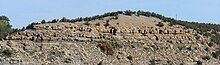 Type locality for the Naturita Formation above the former Nucla coal power plant, Naturita, Colorado | |
| Type | Geological formation |
| Sub-units | Culver Coal Zone member |
| Underlies | Mancos Shale |
| Overlies | Cedar Mountain & Burro Canyon Formations |
| Lithology | |
| Primary | Mudstone |
| Other | Shale, sandstone |
| Location | |
| Coordinates | 37°36′N 112°54′W / 37.6°N 112.9°WCoordinates: 37°36′N 112°54′W / 37.6°N 112.9°W |
| Approximate paleocoordinates | 39°24′N 75°30′W / 39.4°N 75.5°W |
| Region | Colorado, Utah |
| Country | United States |
| Type section | |
| Named for | Naturita, Colorado |
 Naturita Formation (the United States) | |


The Naturita Formation is a classification used in western Colorado and eastern Utah for a Cretaceous Period sedimentary geologic formation. This name was "applied to the upper or carbonaceous part of Dakota Group" by R.G. Young in 1965, naming it for Naturita, Colorado.[1] The name was not generally accepted for that strata,[2] and it has not been used by U.S. Geological Survey authors.[3]
Geology[]

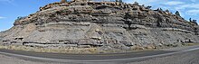
A coal seam is visible below its sandstone bed, with a thin volcanic ash (white) layer in its upper portion.
The formation overlies the Cedar Mountain Formation, and underlies the Mancos Shale formation, thus occupying the position of sedimentary strata that have widely[4] been called Dakota.
Even with Witzke and Ludvigson writing in 1996, "Usage of the term "Dakota" for western-derived sedimentary sequences in the Rocky Mountain area is discouraged.", such usage remains current.[5] Young's description of the Naturita is consistent with other western descriptions of the Dakota Group. Witzke and Ludvigson, et al., later confirmed palynostratigraphic units in the Dakota from Iowa to the Colorado Front Range and acknowledged the recognition of those sequences throughout the Western Interior.[6] In 2012, the Dakota/Naturita Formation sequence and fossil pollen species in Utah were correlated with Ludvigson's reports on the Dakota at the Nebraska type location.[2]
In most areas, the Naturita Formation is composed of a lower unit of conglomeratic sandstone, a middle part of lignitic mudstones and coal, and fine- to medium-grained sandstones in the upper part, which is not inconsistent with broad patterns observed in formation rank Dakota in many locations. The Naturita is not uniform in thickness and in many places is very thin or missing so that the Mancos Formation is in direct contact with the Cedar Mountain Formation.
Where missing, a lag of conglomerate may be present to indicate winnowing of sediments, which occurred by advancing Cretaceous seas. In other places, deposition of Naturita sediments did not occur, and these areas may have been quiet lagoons.
Coastal coal swamps also formed in low areas as the encroaching sea raised the base level of rivers and the water table.
Fossil content[]
Fossils from the Naturita include dinosaur bone fragments of ceratopsians, a possible primitive tyrannosaurid, nodosaurid ankylosaurs, a brachiosaurid sauropod, and the bothremyid turtle .[7][8]
Abundant mammals as well as fossil plants are also known from the coal-rich layers.[9]
Mammals[]
See also[]
- List of fossiliferous stratigraphic units in Colorado
- List of fossiliferous stratigraphic units in Utah
- Paleontology in Colorado
- Paleontology in Utah
- List of dinosaur bearing rock formations
References[]
- ^ Young, R.G. 1965. Type section of the Naturita Formation. Bulletin of the American Association of Petroleum Geologists 49:1512-1516.
- ^ Jump up to: a b Douglas A. Sprinkel, Scott K. Madsen, James I. Kirkland, Gerald L. Waanders, and Gary J. Hunt (2012). "Cedar Mountain and Dakota Formations around Dinosaur National Monument—evidence of the first incursion of the Cretaceous Western Interior Seaway into Utah" (PDF). Utah Geological Survey Special Study. Utah Geological Survey (143). Retrieved February 21, 2021.
The Dakota Formation ... has undergone a colorful history of nomenclature changes. ... Naturita has generally not been an accepted name for this section of rocks on the Colorado Plateau. ... The term Dakota Sandstone has been formally used in geologic maps and reports in the eastern Uinta Mountains (...); however, we revise the descriptive term to formation to reflect the lithologic heterogeneity of the Dakota in this region and to be consistent with usage elsewhere in Utah.
CS1 maint: multiple names: authors list (link) - ^ "Geologic Unit: Naturita". National Geologic Database. Geolex — Significant Publications. United States Geological Survey. Retrieved 2021-02-22.
[Geolex indicates that no U.S. Geological Survey authors have used the name.]
- ^ "Geologic Unit: Dakota". National Geologic Database. Geolex — Significant Publications. United States Geological Survey. Retrieved 2021-02-22.
- ^ Molenaar, C.M., Cobban, W.A., Merewether, E.A., Pillmore, C.L., Wolfe, D.G., and Holbrook, J.M. (2002). "Regional stratigraphic cross sections of Cretaceous rocks from east-central Arizona to the Oklahoma Panhandle". National Geologic Map Database. USGS. Retrieved February 20, 2020.
[The left of sheet 1 illustrates Clay Mesa Tongue (Marcos), Paguate Tongue (Dakota), Whitewater Arroyo Tongue (Marcos), Twowells Tongue (Dakota)]
CS1 maint: uses authors parameter (link) - ^ Greg A. Ludvigson, Brian J. Witzke (2010). "New Insights on the Sequence Stratigraphic Architecture of the Dakota Formation in Kansas–Nebraska–Iowa from a Decade of Sponsored Research Activity". Current Research in Earth Sciences: Palynostratigraphy and Correlation of the Dakota Formation in the Type Area, Iowa, Nebraska, and Kansas. Retrieved March 16, 2021.
- ^ Carpenter, K. 2006. Assessing dinosaur faunal turnover in the Cedar Mountain Formation (Lower Cretaceous) of eastern Utah, USA. Ninth International Symposium on Mesozoic Terrestrial Ecosystems and Biota, Abstract and Proceedings Volume, p. 21-25
- ^ Joyce WG, Lyson TR, Kirkland JI. (2016) An early bothremydid (Testudines, Pleurodira) from the Late Cretaceous (Cenomanian) of Utah, North America. PeerJ 4:e2502 https://doi.org/10.7717/peerj.2502
- ^ Rushforth, S.R. 1971. A flora from the Dakota Sandstone Formation (Cenomanian) near Westwater, Grand County, Utah. Brigham Young University Science Bulletin 14(3):1-44.
- Geologic formations of Colorado
- Geologic formations of Utah
- Lower Cretaceous Series of North America
- Cretaceous Colorado
- Cretaceous geology of Utah
- Cenomanian Stage
- Mudstone formations
- Fluvial deposits
- Shallow marine deposits
- Paleontology in Utah