Nea Penteli
Nea Penteli
Νέα Πεντέλη | |
|---|---|
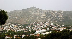 | |
 Nea Penteli Location within Athens  | |
| Coordinates: 38°3′N 23°51′E / 38.050°N 23.850°ECoordinates: 38°3′N 23°51′E / 38.050°N 23.850°E | |
| Country | Greece |
| Administrative region | Attica |
| Regional unit | North Athens |
| Municipality | Penteli |
| • Municipal unit | 3.230 km2 (1.247 sq mi) |
| Elevation | 430 - 520 m (−1,280 ft) |
| Population (2011)[1] | |
| • Municipal unit | 7,198 |
| • Municipal unit density | 2,200/km2 (5,800/sq mi) |
| Time zone | UTC+2 (EET) |
| • Summer (DST) | UTC+3 (EEST) |
| Postal code | 152 36 |
| Area code(s) | 210 |
| Vehicle registration | Z |

Nea Penteli (Greek: Νέα Πεντέλη) is a small municipal unit - village in the northeastern part of the Athens agglomeration, Greece. Since the 2011 local government reform it is part of the municipality Penteli, of which it is a municipal unit.[2]
Geography[]
Nea Penteli is situated at the southwestern foot of the Penteli mountains, at 410 m (1,345.1 ft) elevation. The municipal unit has an area of 3.230 km2.[3] It is 14 km (9 mi) northeast of Athens city centre. At the centre of the village is a small hill named Profitis Ilias, after the small church constructed on top of it. Nea Penteli has one primary school and a high school.
Historical population[]
| Year | Population |
|---|---|
| 1981 | 2,723 |
| 1991 | 4,332 |
| 2001 | 6,156 |
| 2011 | 7,198 |
See also[]
- List of municipalities of Attica
References[]
- ^ a b "Απογραφή Πληθυσμού - Κατοικιών 2011. ΜΟΝΙΜΟΣ Πληθυσμός" (in Greek). Hellenic Statistical Authority.
- ^ "ΦΕΚ B 1292/2010, Kallikratis reform municipalities" (in Greek). Government Gazette.
- ^ "Population & housing census 2001 (incl. area and average elevation)" (PDF) (in Greek). National Statistical Service of Greece.
External links[]
- Cultural Activities department, Πνευματικό Κέντρο
- Public Library of Cultural Activities department, Βιβλιοθήκη Πνευματικού Κέντρου
Categories:
- Populated places in North Athens (regional unit)