Neamț Citadel

Neamț Citadel (Romanian: Cetatea Neamț or Cetatea Neamțului, pronunciation: [ne̯amts]) is a medieval fortress located in north-eastern part of Romania, near Târgu Neamț, Neamț County. It was built in 14th century Moldavia during Petru I of Moldavia's reign and expanded in the 15th century. The citadel played a key role in Stephen III of Moldavia's defense system, along with Suceava, Hotin, Soroca, Orhei, Tighina, Chilia and Cetatea Albă.
History[]
Lack of reliable information on the origins of Neamț Fortress had resulted in several hypotheses whose reliability was often questioned. A number of historians and philologists, as A.D. Xenopol, B.P. Hasdeu, D. Onciul consider that - according to the papal bull of 1232 - the Teutonic Knights of Bârsa had built between 1211–1225 on the eastern slope of the Carpathians a castrum muntissimum which was later identified as the citadel. The Germanic (Teutonic or Saxon) hypothesis was acquired by many of Romanian historians and sustained by both: -the site's onomastic "Neamt", which in Slavonic and Rumanian languages means " German" -and by the fortification style, typical to Imperial German military architecture of Hohenstaufen period XII-XIV centuries. The German knights "the Saxons" have been appointed to fortify the Carpathian passes against the frequent barbarian incursions into Transilvania. The Saxons have been settled in Transilvania (Siebenbürgen- seven castles) since then, 150 years before the founding of later principalities of Valachia and Bogdania(Moldova).
Archaeological research of the citadel has not revealed any evidence of a fortification before the reign of prince Peter II (1375-1391) & oldest coins discovered on the site are from the same reign. The name might be related with the name of the district and later county of Neamț where later ( i.e. early 14th century) Saxon colonists settled in the nearby town of Baia (known then as Moldau).
Gallery[]

Inner Court

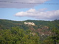
Neamț Citadel

Neamţ Citadel 
The access bridge in the fortress The Northern Wall 
The Western wall 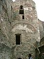
The tower in the northwest corner 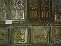
Tiles from Neamț Citadel


See also[]
External links[]
| Wikimedia Commons has media related to Neamț Citadel. |
Coordinates: 47°12′51″N 26°20′36″E / 47.21429°N 26.3433°E


This article about a Romanian building or structure is a stub. You can help Wikipedia by . |
- Castles in Romania
- Castles in Moldavia
- Buildings and structures in Neamț County
- Tourist attractions in Neamț County
- Historic monuments in Neamț County
- Romanian building and structure stubs