Nedroma
Nedroma
ندرومة | |
|---|---|
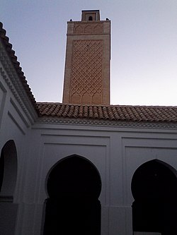 Minaret of the Great Mosque of Nedroma | |
 Nedroma | |
| Coordinates: 35°0′42″N 01°44′56″W / 35.01167°N 1.74889°W | |
| Country | |
| Province | Tlemcen |
| District | Nedroma |
| Area | |
| • Total | 14 km2 (5 sq mi) |
| Population (2008 census) | |
| • Total | 32,398 |
| • Density | 2,300/km2 (6,000/sq mi) |
| Time zone | UTC+1 (CET) |
| Postal code | 13600 |

Nedroma (Arabic: ندرومة) is a city in Tlemcen Province, in northwestern Algeria, about 77 kilometres (48 mi) from Tlemcen. Once the capital of , it was built on the ruins of a Berber town by Abd al-Mu'min the Almohad caliph. It has a great Islamic history, with its Great Mosque of Nedroma once containing the earliest surviving Almoravid minbar. Nedroma became a UNESCO World Heritage in 2002 for its cultural importance.
History[]

Once the capital of , it was built on the ruins of a Berber town by Abd al-Mu'min the Almohad caliph, who himself was a native of the neighboring mountains.[1] the town has a great history of Islam.[2] The earliest surviving Almoravid minbar, dated to around A.H. 479, once belonged to the Great Mosque of Nedroma. It is now on display in the in Algiers.[3] In the 1930s Ulama organizations, particularly the Boy Scouts sprang up in Nedroma and other ancient cities of the interior such as Tlemcen and Constantine.[4]
Riots broke out in the town on 15 October 1953, killing one person and injuring several. 26 were convicted.[5]
Nedroma was added to the UNESCO World Heritage Tentative List on December 30, 2002 in the Cultural category.[1]
Geography[]
Nedroma is situated to the north of the , 77 kilometres (48 mi) from Tlemcen, and about 340 kilometres (210 mi) west of Algiers.[6] The N99 highway passes south-north through the town, connecting it to Maghnia in the south and Ghazaouet on the coast. The W100 road leads to in the southwest, and the W38 road leads to Aïn Kebira and in the northeast.[7]
Landmarks[]
Nedroma contains the Great Mosque of Nedroma (Sidi Yahia Mosque) and the Nedroma Hospital in the northern outskirts along the N99.[7] Baked brick is a common building material in the town.[8]
References[]
- ^ Jump up to: a b "Nedroma et les Trara" (in French). UNESCO World Heritage Centre. Retrieved 15 October 2016.
- ^ Ageron, Charles Robert (1991). Modern Algeria: A History from 1830 to the Present. C. Hurst & Co. Publishers. p. 77. ISBN 978-1-85065-027-0.
- ^ Dodds, Jerrilynn Denise (January 1992). Al-Andalus: The Art of Islamic Spain. Metropolitan Museum of Art. p. 364. ISBN 978-0-87099-636-8.
- ^ Stora, Benjamin; Todd, Jane Marie (2004). Algeria, 1830-2000: A Short History. Cornell University Press. p. 17. ISBN 0-8014-8916-4.
- ^ Holland, R. F (6 December 2012). Emergencies and Disorder in the European Empires After 1945. Routledge. p. 24. ISBN 978-1-136-29725-0.
- ^ Oakes, Jonathan (2008). Algeria. Bradt Travel Guides. p. 149. ISBN 978-1-84162-232-3.
- ^ Jump up to: a b Google (15 October 2016). "Nedroma" (Map). Google Maps. Google. Retrieved 15 October 2016.
- ^ Petersen, Andrew (11 March 2002). Dictionary of Islamic Architecture. Routledge. p. 13. ISBN 978-1-134-61365-6.
Coordinates: 35°00′00″N 1°44′00″W / 35°N 1.7333333°W

| show Authority control |
|---|
- Communes of Tlemcen Province