Negombo
Negombo
| |
|---|---|
| Nickname(s): Punchi Romaya (Little Rome), Meepura (City of Bees) | |
 Negombo Location in Sri Lanka | |
| Coordinates: 7°12′40″N 79°50′19″E / 7.21111°N 79.83861°ECoordinates: 7°12′40″N 79°50′19″E / 7.21111°N 79.83861°E | |
| Country | Sri Lanka |
| Province | Western Province |
| Division | Negombo |
| Government | |
| • Type | Municipal Council |
| • Mayor | Dayan Lanza |
| Area | |
| • Urban | 30 km2 (11.58 sq mi) |
| • Metro | 34 km2 (13.12 sq mi) |
| Elevation | 2 m (7 ft) |
| Population | |
| • Ethnic groups | Sinhalese Sri Lankan Tamils Sri Lankan Moors Sri Lankan Malays Burghers and Sri Lankan Chinese |
| Demonym(s) | Negombians |
| Time zone | UTC+5:30 (Sri Lanka Standard Time Zone) |
| Postal code | 11500 |
| Area code(s) | 031 |

Negombo (Sinhala: මීගමුව, romanized: Mīgamuva, Tamil: நீர்கொழும்பு, romanized: Nīrkoḻumpu) is a major city in Sri Lanka, situated on the west coast and at the mouth of the Negombo Lagoon, in Western Province, 38 km from Colombo via Colombo - Katunayake Expressway.
Negombo is one of the major commercial hubs in the country and the administrative centre of Negombo Division. Negombo has about 142,136 population within its divisional secretariat division.[1]
Negombo is known for its long sandy beaches and centuries old fishing industry. Negombo has a large bilingual (Sinhala/Tamil) population with a clear Roman Catholic majority.
Etymology[]
The name "Negombo" is the Portuguese corrupted name of its Tamil name Neerkolombu.[2][note 1]
The Sinhala name Migamuva means "Village of the honeycomb", gaining its name from a legend mentioned in Rajaveliya.[3] The army of King Kavantissa found bee honey in a canoe near the seashore, for Viharamahadevi who was pregnant with the prince Dutugamunu. Because of this, the place was named "Mee-Gomuwa".[4]
History[]
The shallow waters of the Negombo Lagoon provided safe shelter for seafaring vessels and became one of the key ports along with Kalpitiya, Puttalam, Colombo, Kalutara and Galle, from which the Sri Lankan kingdoms conducted external trade.[5]
Early history[]
The Jaffna kings who controlled greater parts of the North-west coast of Sri Lanka, built fortifications at Negombo, Colombo and Chilaw.[6][7] The language used in and around Negombo was Tamil when the Portuguese colonisers arrived in the 16th century.[8]
Negombo served also as a shelter for Arabic vessels, whose descendants are the Sri Lankan Moors.[9][10] Negombo was a major port known for its trading activity and was well known for its cinnamon cultivation.[11] The cinnamon trade was controlled by the Sri lankan kings and later by the Sri Lankan Moors.[12]
Colonial history[]
Landing in the early 1500s, the Portuguese ousted the Jaffna Kingdom, constructed a fort in Negombo and took over the trade of cinnamon to the west.[13] During the Portuguese occupation, the Karava (the dominant seafaring clan of Negombo), who were previously Buddhist and Hindu, embraced Catholicism.[14] So successfully were they converted that today Negombo is sometimes known as 'Little Rome' and nearly two thirds of its population profess the Catholic faith.[15]

The Portuguese restructured the traditional production and management of cinnamon and maintained their control over the trade for more than a century. The decline of their power began in the 1630s when warfare between the Portuguese and the Kingdom of Kandy reached a stalemate. the King of Kandy turned to the Dutch for help.[16] The Dutch captured Negombo from the Portuguese in 1646 and negotiated an armistice with Portugal for ten years. During this period the King of Kandy sought to provoke conflict between the nations by passing through the territories of the one to attack the other. On one occasion he captured the fort of Negombo and sent the head of the Dutch commander Adrian Vander Stell to his countrymen in Galle.[17] Although the Dutch managed to regain control of Negombo from the King by diplomatic means, hostilities continued. In particular, the disruption of the cinnamon trade was a favourite method of the King to harass the Dutch.[18]
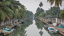
The legacy of the Dutch colonial era can be seen in the Negombo fort, constructed in 1672, other Dutch buildings, churches and the extensive canal system that runs 120 km (75 mi) from Colombo in the south, through Negombo to Puttalam in the north.
Throughout the eighteenth century the demand for cinnamon from Ceylon outstripped the supply, and its quality appears to have suffered. Other factors, including the continued hostility from the Kandian government and a rival cinnamon trade from China, led to a 40% decline in the volume of cinnamon exported between 1785 and 1791. Despite attempts to clear land around Negombo and create cinnamon plantations, by the time the British commander Colonel Stuart took over the trade in 1796, it was clear that the industry was in decline. Poor policies put in place by Frederick North the first Governor of British Ceylon exacerbated the problem. By the 1830s commercial interest had moved elsewhere.
Following the British takeover of the Kingdom of Kandy in 1815, Negombo lost its strategic value as an outpost of Colombo. However it continued to develop in commercial influence. The Negombo fishery was at the heart of the seafood trade in Ceylon, and many migrant fisherman arrived annually with the profits of their ventures going into the small, prosperous town. In 1907 Negombo was connected to the massive railway project that was linking the island together under British control and encouraging the growth of plantations in coconuts, tea and coffee.
Geography and climate[]

Negombo is about 2 metres (6 ft 7 in) above sea level, and Negombo's geography is a mix of land and water. The Dutch canal flows in the heart of the city. The lagoon is one of the most scenic landmarks of Negombo. There are over 190 species of wildlife and plenty of birds in its mangroves. The northern border of the city is formed by the Ma Oya river which meets the Indian Ocean.
Negombo features a tropical rainforest climate under the Köppen climate classification. The city receives rainfall mainly from the Southwestern monsoons from May to August and October to January. During the remaining months there is a little precipitation due to Convective rains. The average annual precipitation is about 2,400 millimetres (94 in). The average temperature varies 24 °C (75 °F) to 30 °C (86 °F), and there are high humidity levels from February to April.
| hideClimate data for Negombo, Sri Lanka | |||||||||||||
|---|---|---|---|---|---|---|---|---|---|---|---|---|---|
| Month | Jan | Feb | Mar | Apr | May | Jun | Jul | Aug | Sep | Oct | Nov | Dec | Year |
| Average high °C (°F) | 30 (86) |
31 (88) |
31 (88) |
31 (88) |
31 (88) |
29 (84) |
29 (84) |
29 (84) |
29 (84) |
29 (84) |
29 (84) |
29 (84) |
30 (86) |
| Average low °C (°F) | 22 (72) |
22 (72) |
23 (73) |
24 (75) |
26 (79) |
25 (77) |
25 (77) |
25 (77) |
25 (77) |
24 (75) |
23 (73) |
22 (72) |
24 (75) |
| Average precipitation mm (inches) | 89 (3.5) |
69 (2.7) |
147 (5.8) |
231 (9.1) |
371 (14.6) |
224 (8.8) |
135 (5.3) |
109 (4.3) |
160 (6.3) |
348 (13.7) |
315 (12.4) |
147 (5.8) |
2,345 (92.3) |
| [citation needed] | |||||||||||||
Negombo Lagoon[]
Negombo Lagoon is large semi-enclosed coastal water body with plenty of natural resources. The lagoon is fed by number of small rivers and the Dutch canal. It is linked to the Indian Ocean by a narrow channel to the north, near Negombo city. The lagoon and the marsh land area also support local agriculture and forestry. It has extensive mangrove swamps and attracts a wide variety of water birds. The lagoon supports so many distinct species of flora, fauna and as well as another species of birds and variety of animals. Negombo Lagoon is a major local and tourist attraction primarily for sightseeing and boating tours.
The fishermen who are based at the Negombo lagoon live in shanty thatch palm villages along the water's edge. They rely mainly on their traditional knowledge of the seasons for their livelihood, using outrigger canoes carved out of tree trunks and nylon nets to bring in modest catches from September through April. Their boats are made in two forms – oruvas (a type of sailing canoe) and paruvas (a large, man-powered catamaran fitted with kurlon dividers). In recent years, the villagers have supplemented the income earned from fishing by collecting 'toddy', or palm sap, which is used to brew arrack.[19]
Zones and neighborhood[]
- Athgala
- Basiyawatte
- Bolawalana [20]
- Dalupotha
- Daluwakotuwa
- Dungalpitiya
- Duwa
- Duwane
- Ethukala [21]
- Kadolkale
- Kamachchodai [22]
- Kandawala
- Kattuwa [23]
- Katuwapitiya [24]
- Kimbulapitiya
- Kochchikade
- Kurana [25]
- Kudapadu
- Mahahunupitiya, also known as Maha Hunupitiya, a predominantly Catholic neighborhood[26][27]
- Munnakkarai
- Muruthena
- Nugawala
- Palangathura
- Pallansena
- Periyamulla [28]
- Pitipana
- Poruthota
- Raheemanabad [29]
- Sarakkuwa
- Sellakanda
- Thillanduwa
- Thaladuwa
- Thalahena
- Udyar Thoppu [30]
- Wella veediya
- Welihena
- Kadirana
- Akkarapanaha
- Thimbirigaskatuwa
- Katana
Transport[]
The Airport Expressway (E03) opened in 2013 links the capital Colombo through the Katunayake Interchange with Negombo city minimising travelling time to approximately 20 to 30 minutes.

There are highway bus services running between from Negombo to Galle and Matara (the southern tip of the country) using the Southern Expressway.
The A3 main road from Colombo, goes through Negombo, extends to Jaffna, and Trincomalee via Anuradhapura. Negombo is connected with some of the B grade roads, and there is a good road network in and around Negombo City.
The Bus Terminal complex of Negombo has multiple facilities for passengers and public. It is served by many bus routes, connecting with some major destinations in the country.
Due to Negombo being situated along A3 Main Road, it is served by many bus routes from Colombo to Northern and North western points of Sri Lanka including Jaffna, Vavuniya, Padaviya, Kilinochchi, Mullaitivu, Pulmude, Mannar, Kankasanthura, Point Pedro, Velvetithurai, Nikaweratiya, Panduwasnuwara, Anamaduwa and Silawathurai.

Four railway stations serve Negombo, they are: Kurana, Negombo Downtown, Kattuwa and Kochchikade. Negombo Downtown Station is the main railway station on the Puttalam railway line. It serves Panadura, via Colombo from south and to Puttalam, via Chilaw from north. The Sri Lanka Railway Department has introduced an intercity express train between Chilaw and Colombo with stops at Negombo Downtown and Kochchikade Stations.
The Negombo Downtown Station is close to the central Bus Terminal Complex. Negombo is the closest major city to the Bandaranaike International Airport.
Demographics[]
According by the statistics of 2011, 6.3% of the population of Gampaha district live in Negombo city limits and 11.6% of the population of the district live in Negombo Metropolis.[citation needed] It is a multi-ethnic and multi-cultural city. Most of Negombo's residents belong to the Sinhalese majority. There are Tamil and Muslim people also living in the city. There is a local Sri Lankan Chinese community living in the city.
| 2012 Population | Percentage | |
|---|---|---|
| Roman Catholic | 92,527 | 65.31% |
| Muslim | 20,308 | 14.33% |
| Buddhist | 15,681 | 11.07% |
| Hindu | 8,290 | 5.85% |
| Other Christian | 4,740 | 3.35% |
| Other | 130 | 0.09% |
| Total | 141,676 | 100.00% |
| Sinhalese | 107,155 | 75.63% |
| Sri Lankan Moor | 19,364 | 13.67% |
| Sri Lankan Tamil | 12,590 | 8.89% |
| Indian Tamil | 904 | 0.64% |
| Other | 599 | 0.42% |
| Burgher | 414 | 0.29% |
| Baratha | 281 | 0.20% |
| Malay | 278 | 0.20% |
| Sri Lankan Chetty | 91 | 0.06% |
| Total | 141,676 | 100.00% |
Religion[]
Negombo is a multi-religious city. Since the beginning of European colonization, the township of Negombo has had a majority of Roman Catholics along with Buddhists, Hindus and Muslims.
- Catholic and Christian churches

Negombo has been given the name Little Rome due to the highly ornate Portuguese-era Roman Catholic churches such as St. Mary's Church found in the township and because the majority are the Roman Catholics. St. Sebastian's Church, Katuwapitiya, Saint Stephen’s Church, Negombo, Grand Street St.Mary's Church, St. Anne's churches at Kurana and Palangatura, St. Anthony's church Dalupotha and Our Lady of Sorrows Church, Kandawala are the biggest parishes in Negombo. There are over 25 Roman Catholic churches in the city.
There is a branch of The Church of Jesus Christ of Latter-day Saints in Negombo. The church building is just west of the intersection of Ave Maria street and Old Chilaw street. There are also Methodist churches, Baptist churches, and the other Anglican churches in Negombo.
- Buddhist temple
Agurukaramulla Raja Maha Viharaya (Bodhirajaramaya) is a famous Buddhist temple bringing Buddhists from all over Sri Lanka to Negombo every year. Abhayasekararamaya temple (Podipansala), Sri Sudarshanaramaya, Dutugamunu viharaya and Sri Buddhagaya maha viharaya are famous Buddhist temples in the city.
- Hindu Kovil (temple)
There are many Hindu temples (Kovil) in Negombo: Kali Amman temple, Ganapathi (Pillaiar) Temple, Kamachchi Amman Temple, Muththumari Amman Temple, Murugan (Kandaswami) Temple, Karumari Amman Temple etc.
- Muslim Masjid (mosques)

There are nine Jummah Mosques in Negombo. The Kamachchoda Jummah Masjid in Kamachchoda, Negombo is one of the oldest in Sri Lanka.[citation needed] Another old Msajid in Negombo is the Udayar Thoppuwa Mosque, Mirigama Road, Dheen Junction, Negombo which was built in 1846 by Maththicham Saleem Lebbe Muhammed Thamby Vidane and the old building which was built in 1846 is still in use.
Local government[]
Negombo City Local Board began in 1878. After 44 years, it became the Urban District Council on 1 January 1922. Negombo celebrated its silver jubilee of its Urban council status in grand style in February 1948. Their Royal Highnesses the Duke and Duchess of Gloucester were the main patrons on the opening day of the celebrations. The Negombo Urban Council was offered Municipal status on 1 January 1950 under the municipal ordinance of 1865.
The Negombo Municipal Council has governed the city with a mayor from the government, since 1950. Negombo's mayor and the council members are elected through the local government election held every five years. There are 29 wards in the Negombo municipal boundary. Each is represented by an elected member, but[when?] there were only 26 members before the Local Government election held in 2018. The number of municipal councillors was increased to 48 according to new local government election system introduced in 2018. where 29 members are elected form wards and the rest form a preferential list.
In the Local Government Election held in 2018,[33] United National Party Won the Negombo Municipal council led by former Western Provincial councillor Royce Fernando by securing 19 seats and Sri Lanka Podujana Peramuna led By Dayan Lanza, brother of Nimal Lanza (MP) secured 16 Seats. The rest of seats were distributed among other political Parties and independent groups including Sri Lanka Freedom Party.[34] Dayan Lanza became the Mayor of Negombo with the support of minor political parties and Sri Lanka Freedom Party. Royce Fernando Became the Opposition Leader in Negombo Municipal council.
Economy[]
Negombo considered as one of the largest economic centre of the country.[citation needed] Negombo is about 5–6 km from the Bandaranaike International Airport, and the free trade zone. Negombo has a moderate fish port (used during the periods of Portuguese and Dutch colonization)
The economy of Negombo is mainly based on tourism and its centuries-old fishing industry, though it also produces cinnamon,[19] ceramics, and brass ware.
The Colombo Stock Exchange-Negombo branch and many major financial corporations have their key branches in Negombo. There are department stores, large supermarkets, and boutiques in the bustling streets of Downtown and international food outlets are being opened.

Education[]
Negombo is home to some of the oldest secondary educational institutes in Sri Lanka. The leading schools are listed below.
|
|
|
|
There are also many higher educational institutes and private tuition institutes in Negombo City: Ocean University of Sri Lanka Negombo faculty conducts Nautical Engineering, Marine Science, Fisheries and other degree programmes. Pope Benedict higher educational and Cultural Centre, Gateway Graduate School, Horizon Campus, Regent Language School, ACBS Campus, IPM Institute of Sri Lanka, ACCHE, SLIMM, AIMS College, American College of Higher Education, Australian Higher Educational Centre, E-Soft Institute, Electro Technical Institute and Don Bosco Technical College, IDM Institute are some of them.
Notable people[]
- William Mohotti Munasinghe, Aide-de-camp to the British Governor and Mudaliyar of Negombo
- Mudaliyar John de Silva Wijegooneratne Rajapakshe (d.1909) [35]
- Muhammed Thamby Samsudheen (1860 – 1915),[36] was the Vidane Arachchi of Negombo from 1896 to 1915, the highest position held by a Muslim in Negombo in the Native Department. After completing the Cambridge Senior Examination he got involved in managing the family estates before being appointed as the Vidane Arachchi. He was the third child of Maththicham Saleem Lebbe Muhammed Thamby Vidane (1819–1884). Dheen Junction [37] in Negombo is named after him. Udayar Thoppuwa Mosque [38] at Dheen Junction in Negombo was built by his father in 1846. The Masjid is maintained by his descendants, who continue to preserve the original building.
- A. E. Rajapakse (13 March 1866 – 20 September 1937), was the first chairman of the Negombo Urban Council (1922–1923, 1925-1934). He was the eldest son of Mudliyar John de Silva Wijegooneratne Rajapakshe. Rajapakse Park and Rajapakse Broadway in Negombo are named after him.
- Samsudheen M. Abdul Raheeman (1896 – 1965), was the first Muslim chairman of the Negombo Urban Council (20 November 1941 to 31 December 1943). He was the second Muslim (first was his elder brother S. I. Dheen) to qualify as a lawyer in Negombo and was the 8th (1st Muslim) President (1948–1958) of the Negombo Law Society. He was the fourth child of Muhammed Thamby Samsudheen Vithane Arachchi. Raheemanabad [39] in Periyamulla Negombo is named after him
- Mudaliyar T. David Mendis, founder and owner of Wijaya Bus Company, which was nationalised on 1 January 1958. Mudaliyar Mendis Mawatha in Negombo is named after him.
- Thomas Cooray (28 December 1901 – 29 October 1988), first indigenous Archbishop of Colombo (1947 - 1976) and first Sri Lankan Cardinal (1965 - 1988).
- Frank Marcus Fernando (19 October 1931 - 24 August 2009), served as Bishop of the Roman Catholic Diocese of Chilaw (1972 - 2006).
- Nicholas Fernando (6 December 1932 - 10 April 2020), served as Archbishop of the Roman Catholic Archdiocese of Colombo (1977 - 2002).
- Wijayapala Mendis (16 December 1928 - 1 September 2012), was elected the Mayor of Negombo in 1954 and entered Parliament in 1960 from the Katana electorate as a UNP candidate. He was appointed Minister of Textile Industries in 1977, in 1989 he became the Minister of Transport and Highways, In 1993 he was appointed Leader of the House and in 1994 he became the Chief Opposition Whip in Parliament which he served till 1998. He was the third child of Mudliyar T. David Mendis of Negombo.Wijayapala Mendis Road in Negombo is named after him.
- Ranjan Ramanayake (11 March 1963), was an actor, director and screenwriter before entering Parliament in 2010 as the member for Ratnapura. In 2015 he was elected as a member for Gampaha. He served as the State Minister of Highways and Road Development (2018-2019).
See also[]
- Kandawala
- Negombo Tamils
- Bharatakula
- RAF Negombo
- Place names in Sri Lanka
| show Places adjacent to Negombo |
|---|
References[]
- ^ "Census of Population and Housing of Sri Lanka, 2012" (PDF). Department of Census and Statistics, Sri Lanka. p. 1.
- ^ Proceedings. International Association of Tamil Research, Department of Indian Studies, University of Malaya. 1968. p. 481.
- ^ Senaveratna, John M. (1997). The Story of the Sinhalese from the Most Ancient Times Up to the End of "the Mahavansa" Or Great Dynasty: Vijaya to Maha Sena, B.C. 543 to A.D.302. Asian Educational Services. p. 96. ISBN 9788120612716.
- ^ Guṇasēkara, B. (1900). The Rājāvaliya: Or, A Historical Narrative of Siṇhalese Kings from Vijaya to Vimala Dharma Sūriya II, to which are Added a Glossary and a List of Sovereigns. Government Printer. p. 24.
- ^ De Silva, K (1981). A History of Sri Lanka. University of California Press. pp. 89–91. ISBN 0-520-04320-0.
- ^ Chitty, Simon Casie (1988). The Castes, Customs, Manners and Literature of the Tamils. Asian Educational Services. p. 33. ISBN 9788120604094.
- ^ The Journal of the Ceylon Branch of the Royal Asiatic Society of Great Britain & Ireland. The Branch. 1859. p. 79.
- ^ Pārati, Paktavatcala (1999). Coromandel fishermen: an ethnography of Paṭṭaṇavar subcaste. Pondicherry Institute of Linguistics and Culture. p. 9. ISBN 9788185452098.
- ^ Silva, S. F. De (1954). A Regional Geography of Ceylon. Colombo Apothecaries' Company. p. 147.
- ^ The Annual Register, or a View of the History, Politics and Literature, For the Year 1817. London: Baldwin, Cradock, and Joy. 1817. pp. 511.
- ^ The Ceylon Journal of Historical and Social Studies. Ceylon Historical and Social Studies Publications Board. 1975. p. 103.
- ^ Dewaraja, Lorna Srimathie (1 January 1994). The Muslims of Sri Lanka: One Thousand Years of Ethnic Harmony, 900–1915. Lanka Islamic Foundation. p. 40. ISBN 9789559297000.
- ^ Epigraphia Zeylanica: Being Lithic and Other Inscriptions of Ceylon. Printed at the Department of Government Printing, Sri Lanka (Ceylon) for the Archeological Department. 1973. p. 86.
- ^ Chicago Anthropology Exchange. Department of Anthropology, University of Chicago. 1987. p. 54.
- ^ International political science abstracts. 1970. p. 102.
- ^ Newitt, Marlyn (2005). A history of Portuguese overseas expansion, 1400–1668. New York: Routledge. p. 234.
- ^ Tennent, James (1860). Ceylon: an account of the island physical, historical and topographical, with notices of its natural history, antiquities, and productions, Volume 2. London: Longman, Green, Longman and Roberts. p. 44.
- ^ Obeyesekere, Donald (1999). Outlines of Ceylon history. Neh Delhi: Asian Educational Services. p. 257.
- ^ Jump up to: a b "The Old Man and the Sea". Global Village. Episode 1927. 29 April 2009.
- ^ "Bolawalana".
- ^ "Ethukala".
- ^ "Kamachchode".
- ^ "Kattuwa".
- ^ "Katuwapitiya".
- ^ "Kurana".
- ^ "Mahunupitiya".
- ^ "Why Kill the Innocents?". The New York Times. 22 April 2019. Retrieved 22 April 2019.
- ^ "Periyamulla".
- ^ "Raheemanabad".
- ^ "Udayar Thoppuwa".
- ^ "Department of Census and Statistics Sri Lanka – Population by divisional secretariat division, religion and sex- 2012" (PDF).
- ^ "Department of Census and Statistics Sri Lanka – Population by ethnicity and district according to Divisional Secretary's Division, 2012".
- ^ "Local Authorities Election 2018 Results – Sri Lanka – Adaderana". adaderana.lk.
- ^ "SLPP's Dayan Lanza elected Mayor of Negombo despite UNP win". www.adaderana.lk.
- ^ "Family #3729 Rajapakse of Negombo". Sri Lankan Sinhala Family Genealogy. rootsweb.
- ^ "Family # 214 Maththicham Saleem Lebbe Muhammed Thamby Vidane (1819–1884) of Negombo".
- ^ "Dheen Junction of Negombo".
- ^ "Udayar Thoppuwa Mosque , Dheen Junction Negombo)".
- ^ "Raheemanabad".
Notes[]
- ^ Excerpt for the etymology of Negombo from "Proceedings". International Association of Tamil Research, Department of Indian Studies, University of Malaya. 1968. p. 481: "In this context, it may be of interest to cite a few place-names in other parts of the Island, with a Tamil origin; in the Western Coast such as Puttalam, Ciläpam (Chilaw), Nirkolumbo (Nikumpalai, Negombo), Kalattarai (Kalutara), Pãnanturai (Pãnadura), Mätarai (Matara), Teivanturai (Dondra)..."
External links[]
| Wikimedia Commons has media related to Negombo. |
 Negombo travel guide from Wikivoyage
- Negombo Municipal Council
| show Authority control |
|---|
- Negombo
- Populated places in Gampaha District
- Populated places in Western Province, Sri Lanka