Neiafu (Vavaʻu)
Neiafu | |
|---|---|
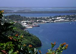 Port of Refuge viewed from Mt. Talau | |
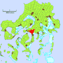 Location of Neiafu on Vavaʻu Island | |
 Neiafu Location of Neiafu on Vavaʻu Island | |
| Coordinates: 18°39′03″S 173°58′59″W / 18.65083°S 173.98306°WCoordinates: 18°39′03″S 173°58′59″W / 18.65083°S 173.98306°W | |
| Country | |
| Island | Vavaʻu |
| Population (2016) | |
| • Total | 3,731 |
| Time zone | UTC+13 (–) |
| Climate | Af |

Neiafu is the second-largest town in Tonga with a population of 3,731 in 2016. It is situated beside the Port of Refuge, a deep-water harbour on the south coast of Vavaʻu, the main island of the Vavaʻu archipelago in northern Tonga. To the north-west lies the 131-metre high (430 ft) Mt. Talau with its distinctive flat top.
Neiafu is the administrative centre of the Vavaʻu group and has government offices, banks, schools, a police station and a hospital. It is also an important centre for tourism with many yachts anchoring in the Port of Refuge.
External links[]
| hide Authority control | |
|---|---|
| General | |
| National libraries | |
| Other | |
This Tongan location article is a stub. You can help Wikipedia by . |
Categories:
- Populated places in Tonga
- Vavaʻu
- Tonga geography stubs