Neualmbach
This article may be expanded with text translated from the corresponding article in German. (September 2011) Click [show] for important translation instructions.
|
| Neualmbach Neualpbach | |
|---|---|
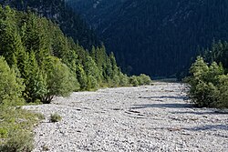 River bed of the Neualmbach shortly before its confluence with the Fischbach | |
| Location | |
| Countries | Austria and Germany |
| States | Tyrol and Bavaria |
| Physical characteristics | |
| Source | |
| • coordinates | 47°31′10″N 10°54′57″E / 47.5194°N 10.9158°E |
| Mouth | |
• location | confluence with the Fischbach in the between Reutte and Oberammergau, forming the Linder |
• coordinates | 47°32′15″N 10°53′25″E / 47.5374°N 10.8903°ECoordinates: 47°32′15″N 10°53′25″E / 47.5374°N 10.8903°E |
| Basin features | |
| Progression | Linder→ Amper→ Isar→ Danube→ Black Sea |

The Neualmbach, also called Neualpbach, is a river which lies in its entire course on the border between Bavaria, Germany and Tyrol, Austria[1][2], in the Ammergau Alps.
The Neualmbach is the right headwater of the Linder. The confluence with the other headstream, the Fischbach, is in the between Reutte and Oberammergau.[2]
See also[]
References[]
- ^ Google (27 February 2020). "Neualmbach source" (Map). Google Maps. Google. Retrieved 27 February 2020.
- ^ a b Google (27 February 2020). "Neualmbach mouth" (Map). Google Maps. Google. Retrieved 27 February 2020.
This Tyrol location article is a stub. You can help Wikipedia by . |
Categories:
- Tributaries of the Amper
- Rivers of Bavaria
- Rivers of Tyrol (state)
- Ammergau Alps
- Rivers of Austria
- Rivers of Germany
- Austria–Germany border
- International rivers of Europe
- Border rivers
- Bavaria river stubs
- Tyrol geography stubs
- Austria river stubs