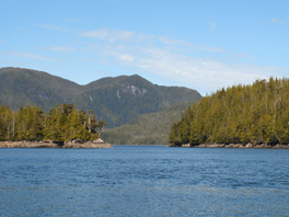
Newcombe Harbour
| Newcombe Harbour | |
|---|---|
 Entrance to Newcombe Harbour, off Petrel Channel, part of Pitt Island | |
 Newcombe Harbour | |
| Location | British Columbia, Canada |
| Coordinates | 53°42′47″N 130°05′18″W / 53.71306°N 130.08833°WCoordinates: 53°42′47″N 130°05′18″W / 53.71306°N 130.08833°W |
| Type | Harbor |
| Native name | Error: {{native name}}: an IETF language tag as parameter {{{1}}} is required |
| Part of | Pitt Island |
| Max. length | 0.75 nautical miles (1.39 km; 0.86 mi) |
| Max. width | 0.25 nautical miles (0.46 km; 0.29 mi) |
| Max. depth | 13 fathoms (78 ft; 24 m) |
Newcombe Harbour is a natural harbour located within the traditional territory of the Gitxaala Nation, on Pitt Island, British Columbia, Canada. Currently named after Captain Holmes Newcombe who was with the Fisheries Protection Service from 1903 to 1923.[2]
The entrance is 300 feet (91 m) wide, while the body is 0.75 nautical miles (1.39 km; 0.86 mi) long and between 0.0125–0.25 nautical miles (0.0232–0.4630 km; 0.0144–0.2877 mi) wide. The harbor has drying banks at its head, and is surrounded by nine mountains.[3]
| Wikimedia Commons has media related to Newcombe Harbour. |
References[]
- ^ MARSDEN S. REPORT SUBMITTED TO (2011). THE GITKXAALA, THEIR HISTORY, AND THEIR TERRITORIES (PORCHER ISLAND, BANKS ISLAND, PITT ISLAND AND ADJACENT ISLANDS) (pdf) (Report). JANES FREEDMAN KYLE LAW CORPORATION. p. 55.CS1 maint: uses authors parameter (link)
- ^ "Newcombe Harbour". BC Geographical Names.
- ^ "Chart 3746, Petrel Channel". Sailing Directions, British Columbia Coast, (Northern Portion). II (Ninth Edition): 259. 1983.
Categories:
- British Columbia Coast geography stubs
- North Coast of British Columbia
