Niederrad
Niederrad | |
|---|---|
Stadtteil of Frankfurt am Main | |
 Coat of arms | |
show Location of Niederrad (red) and the Ortsbezirk Süd (light red) within Frankfurt am Main | |
 Niederrad | |
| Coordinates: 50°05′18″N 08°38′37″E / 50.08833°N 8.64361°ECoordinates: 50°05′18″N 08°38′37″E / 50.08833°N 8.64361°E | |
| Country | Germany |
| State | Hesse |
| Admin. region | Darmstadt |
| District | Urban district |
| Town | Frankfurt am Main |
| Area | |
| • Total | 2.894 km2 (1.117 sq mi) |
| Population (2019-12-31) | |
| • Total | 26,488 |
| • Density | 9,200/km2 (24,000/sq mi) |
| Time zone | UTC+01:00 (CET) |
| • Summer (DST) | UTC+02:00 (CEST) |
| Postal codes | 60528 |
| Dialling codes | 069 |
| Vehicle registration | F |
| Website | www.niederrad.de |
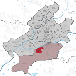


Niederrad is a city district of Frankfurt am Main, Germany. It is part of the Ortsbezirk Süd and is subdivided into the Stadtbezirke Niederrad-Nord, Niederrad-Süd and the new Niederrad-West.
History[]
The district is mainly designated as residential area. It includes the early social housing area of Bruchfeldstraße which was planned by the urban planners in the 1920s under the direction of Ernst May, the Adolf-Miersch housing area (1957/58) and the high-rise Mainfeld residential area (begun in 1963, built mainly during the early 1970s).[1]
In 1151 Niederrad was mentioned for the first time in a document, referring to it simply as "Rode" (literally: "the clearing") in the imperial forest between Sachsenhausen and Schwanheim.[2]
In 1193 the Sandhof, a (small) royal moated castle, is mentioned for the first time.
In 1221 the Sandhof passes into the possession of the Teutonic Order (until 1809).
In 1552 Niederrad and the Sandhof are put to the torch by Markgrave Alcibiades of Brandenburg.
In 1616, another fire almost completely burns Niederrad to the ground.
In 1726 the first protestant church is built (now: Paul-Gerhard-Gemeinde).
Around 1750 the Sandhof gets a baroque architectural makeover.
Between 1761 and 74 the Frauenhof is built. The building is first used for a cotton printing factory by the merchant Johann Friedrich Müller.
Around 1850 Niederrad's population increases to 2,000 people.
In 1866 Niederrad, like Frankfurt am Main, is annected by Prussia, as a result of the Austro-Prussian War.
In 1871 Niederrad's first catholic church is built.
In 1887 the Sandhof, who came into possession of the city government in 1884, is turned into a (part of) a hospital that would later become the hospital of the Frankfurt University.
On July 1st of 1900 Niederrad is officially integrated into the city of Frankfurt. (Population at the time: 8,800 people.) Before, it was only part of the surrounding district.
In 1930 Niederrad reaches a population of 14,000 people. At the same time the psychiatric clinic is built by Ernst May and Professor Elsässer.
In 1932/33 a new catholic church is built.
In 1944 the Sandhof is destroyed by allied bombardment. Other parts of Niederrad are also severely damaged.
In 1950 Niederrad's population reaches 18,000 people.
As of 2019, Niederrad had a population of 26,488 people.[3]
Situation[]
Niederrad is the site of the western part of the University Hospital Frankfurt, Frankfurt naming of some important institutions, but the racecourse Niederrad is located administratively in the district of Sachsenhausen and the Niederrad business district "Bürostadt" belongs almost exclusively to the District Schwanheim, more precisely, its settlement Goldstein. Also the sewage treatment plant is located at the Niederrad-Schwanheim district border.
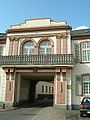
Frauenhof, a baroque building in Niederrad from 1761

Niederrad racecourse

Bruchfeldstraße

Mainfeld, a residential area


| Wikimedia Commons has media related to Frankfurt-Niederrad. |
| show Districts of Frankfurt am Main |
|---|

| Authority control |
|---|
References[]
This Hesse location article is a stub. You can help Wikipedia by . |
- Districts of Frankfurt
- Hesse geography stubs