Niederstetten
show This article may be expanded with text translated from the corresponding article in German. (February 2009) Click [show] for important translation instructions. |
Niederstetten | |
|---|---|
 Town hall | |
 Coat of arms | |
show Location of Niederstetten within Main-Tauber-Kreis district | |
 Niederstetten | |
| Coordinates: 49°24′03″N 09°55′05″E / 49.40083°N 9.91806°ECoordinates: 49°24′03″N 09°55′05″E / 49.40083°N 9.91806°E | |
| Country | Germany |
| State | Baden-Württemberg |
| Admin. region | Stuttgart |
| District | Main-Tauber-Kreis |
| Government | |
| • Mayor | Heike Naber |
| Area | |
| • Total | 104.06 km2 (40.18 sq mi) |
| Elevation | 306 m (1,004 ft) |
| Population (2020-12-31)[1] | |
| • Total | 4,800 |
| • Density | 46/km2 (120/sq mi) |
| Time zone | UTC+01:00 (CET) |
| • Summer (DST) | UTC+02:00 (CEST) |
| Postal codes | 97996, 97980 (Mönchshof) |
| Dialling codes | 07932, 07933, 07939 (Heimberg) |
| Vehicle registration | TBB, MGH |
| Website | www.niederstetten.de |


| Wikimedia Commons has media related to Niederstetten. |
Niederstetten (German: [niː.dɐˈʃtɛ.tn̩] (![]() listen)) is a town and a municipality in the Main-Tauber district, in Baden-Württemberg, Germany. It is situated 14 km southeast of Bad Mergentheim, and 19 km west of Rothenburg ob der Tauber.
listen)) is a town and a municipality in the Main-Tauber district, in Baden-Württemberg, Germany. It is situated 14 km southeast of Bad Mergentheim, and 19 km west of Rothenburg ob der Tauber.
Sights[]
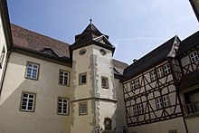
Inner courtyard of castle Haltenbergstetten
The main attraction is the Castle Haltenbergstetten.
Museum[]
The is in memory of last German airship captain Albert Sammt and shows original parts as well as documents of Zeppelin history.
Economy, industry and infrastructure[]
Military[]
Niederstetten is home to German Army Aviation Transport Helicopter Regiment 30 based at Niederstetten Air Base.
International relations[]
Niederstetten is twinned with:
| show Towns and municipalities in Main-Tauber (district) |
|---|
References[]
- ^ "Bevölkerung nach Nationalität und Geschlecht am 31. Dezember 2020". Statistisches Landesamt Baden-Württemberg (in German). June 2021.
| show Authority control |
|---|
This Main-Tauber district location article is a stub. You can help Wikipedia by . |
Categories:
- Towns in Baden-Württemberg
- Main-Tauber-Kreis
- Württemberg
- Stuttgart region geography stubs