Nigerian lowland forests
| Nigerian lowland forests | |
|---|---|
 Forest near Benin City | |
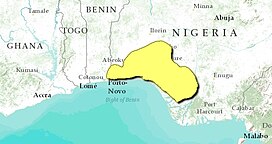 Map of the Nigerian lowland forests | |
| Ecology | |
| Realm | Afrotropical |
| Biome | Tropical and subtropical moist broadleaf forests |
| Borders | Central African mangroves, Cross-Niger transition forests, Guinean forest-savanna mosaic and Niger Delta swamp forests |
| Geography | |
| Area | 67,340 km2 (26,000 sq mi) |
| Countries | Nigeria and Benin |
| Coordinates | 6°48′N 5°00′E / 6.8°N 5.0°ECoordinates: 6°48′N 5°00′E / 6.8°N 5.0°E |
| Conservation | |
| Conservation status | critical/endangered |

The Nigerian lowland forests is a tropical moist forest ecoregion in southwestern Nigeria and southeastern Benin. The ecoregion is densely populated, and home to several large cities including Lagos, Ibadan, and Benin City. There is still significant tree cover, but the remaining enclaves of forest are increasingly fragmented. The ecoregion is wetter along the coast and drier inland, resulting in bands of vegetation zones that run parallel to the coast for the 400 km length of the region.[1] [2] [3] [4]
Geography[]
The Nigerian lowland forests are bounded on the south by coastal mangroves and the Gulf of Guinea, on the east by the Niger River and its delta, on the north by the Guinean forest-savanna mosaic. On the west it is bounded by the Dahomey Gap, a drier coastal region where forest-savanna mosaic extends all the way to the ocean, separating the Lower Guinean forests, of which the Nigerian lowland forests are part, from the Upper Guinean forests of West Africa.[5]
Climate[]
The climate of the ecoregion is Tropical savanna climate - dry winter (Köppen climate classification (Aw)). This climate is characterized by relatively even temperatures throughout the year, and a pronounced dry season. The driest month has less than 60 mm of precipitation, and is drier than the average month.[6][7]
Flora and fauna[]
About 48% of the territory is closed forest, mostly boradleaf evergreen trees. Another 36% is open forest, 5% is urban and built up, and the remainder is wetland and herbaceous cover.[3] Because rainfall declines with distance from the sea, the ecoregion exhibits climate bands with vegetation zones that parallel the coast. Closest to the sea is the rain forest zone, then the mixed deciduous forest zone and farthest inland the parkland zone.[1] In the rainforest zone the common trees are of the Leguminosae family (Brachystegia), , Gossweilerodendron balsamiferum, Piptadeniastrum africanum, and by the Meliaceae family (Entandrophragma, Guarea, Khaya ivorensis, and Lovoa trichilioides.[1]
While in general the levels of animal endemism is low in the ecoregion, there are some notable endemic species. The endangered white-throated guenon (Cercopithecus erythrogaster) is only found in this ecoregion. The endangered Ibadan malimbe (Malimbus ibadanensis) is found in the northern parkland zone. A recent survey of the Niger Delta recorded the endangered crested genet (Genetta cristata). The Nigeria crag gecko (Cnemaspis petrodroma) and the Petter's toad (Bufo perreti) have also been recorded in the region.[1]
Protected areas[]
Nominally, about 17% of the ecoregion is under some form of official protection, including:[3]
References[]
- ^ Jump up to: a b c d "Nigerian lowland forests". World Wildlife Federation. Retrieved June 20, 2020.
- ^ "Map of Ecoregions 2017". Resolve, using WWF data. Retrieved June 20, 2021.
- ^ Jump up to: a b c "Nigerian lowland forests". Digital Observatory for Protected Areas. Retrieved June 20, 2021.
- ^ "Nigerian lowland forests". The Encyclopedia of Earth. Retrieved June 20, 2021.
- ^ "Nigerian lowland forests". WWF ecoregion profile. Accessed 18 April 2020. [1]
- ^ Kottek, M., J. Grieser, C. Beck, B. Rudolf, and F. Rubel, 2006. "World Map of Koppen-Geiger Climate Classification Updated" (PDF). Gebrüder Borntraeger 2006. Retrieved September 14, 2019.CS1 maint: multiple names: authors list (link)
- ^ "Dataset - Koppen climate classifications". World Bank. Retrieved September 14, 2019.
- Nigerian lowland forests
- Afrotropical ecoregions
- Ecoregions of Nigeria
- Tropical and subtropical moist broadleaf forests