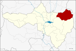
Nong Bua district
This article does not cite any sources. (December 2009) |
Nong Bua
หนองบัว | |
|---|---|
 District location in Nakhon Sawan province | |
| Coordinates: 15°51′54″N 100°35′10″E / 15.86500°N 100.58611°ECoordinates: 15°51′54″N 100°35′10″E / 15.86500°N 100.58611°E | |
| Country | Thailand |
| Province | Nakhon Sawan |
| Area | |
| • Total | 819.5 km2 (316.4 sq mi) |
| Population (2005) | |
| • Total | 70,609 |
| • Density | 86/km2 (220/sq mi) |
| Time zone | UTC+7 (ICT) |
| Postal code | 60110 |
| Geocode | 6004 |
Nong Bua (Thai: หนองบัว, pronounced [nɔ̌ːŋ būa̯]) is a district (amphoe) in the northeastern part of Nakhon Sawan province, central Thailand.
History[]
The government separated some tambons of Chum Saeng district, Tha Tako district, and Bang Mun Nak district of Phichit province to create the minor district (king amphoe) Nong Bua on 1 January 1948. It was upgraded to a full district on 6 June 1956.
Geography[]
Neighboring districts are (from the north clockwise): Bang Mun Nak and Dong Charoen of Phichit province; Chon Daen and Bueng Sam Phan of Phetchabun province; and Phaisali, Tha Tako, and Chum Saeng of Nakhon Sawan Province.
Administration[]
The district is divided into nine sub-districts (tambons), which are further subdivided into 105 villages (mubans). Nong Bua is a township (thesaban tambon) covering parts of tambons Nong Bua and Nong Klap. There are a further nine tambon administrative organizations (TAO).
| No. | Name | Thai name | Villages | Pop. |
|---|---|---|---|---|
| 1. | Nong Bua | หนองบัว | 20 | 15,342 |
| 2. | Nong Klap | หนองกลับ | 15 | 13,103 |
| 3. | Than Thahan | ธารทหาร | 9 | 7,977 |
| 4. | Huai Ruam | ห้วยร่วม | 11 | 4,595 |
| 5. | Huai Thua Tai | ห้วยถั่วใต้ | 7 | 2,178 |
| 6. | Huai Thua Nuea | ห้วยถั่วเหนือ | 9 | 3,580 |
| 7. | Huai Yai | ห้วยใหญ่ | 6 | 2,938 |
| 8. | Thung Thong | ทุ่งทอง | 14 | 9,876 |
| 9. | Wang Bo | วังบ่อ | 14 | 11,020 |
References[]
- Districts of Nakhon Sawan province
- Northern Thailand geography stubs
