Nord-Ubangi
Nord-Ubangi | |
|---|---|
| Province du Nord-Ubangi | |
 | |
| Coordinates: 4°17′N 21°1′E / 4.283°N 21.017°ECoordinates: 4°17′N 21°1′E / 4.283°N 21.017°E | |
| Country | |
| Established | 2015 |
| Capital | Gbadolite |
| Government | |
| • Governor | Izato Nzege Koloke[1] |
| Area | |
| • Total | 56,644 km2 (21,870 sq mi) |
| Population (2005 est.) | |
| • Total | 1,482,076 |
| • Density | 26/km2 (68/sq mi) |
| Time zone | UTC+1 (WAT) |
| Official language | French |
| National language | Lingala |

Nord-Ubangi (French for "North Ubangi") is one of the 21 new provinces of the Democratic Republic of the Congo created in the 2015 repartitioning. Nord-Ubangi, Équateur, Mongala, Sud-Ubangi, and Tshuapa provinces are the result of the dismemberment of the former Équateur province.[2]
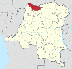
The province is located in the northwestern part of the country on the Ubangi River and was formed from the Nord-Ubangi district and the independently administered city of Gbadolite which became the capital of the new province.
Administration[]
The capital is the city of Gbadolite.[3] It is divided into four territories:
- Bosobolo
- Businga
- Mobayi-Mbongo
- Yakoma
References[]
- ^ "Congo (Kinshasa) provinces". Rulers. Retrieved 5 July 2019.
- ^ "Découpage territorial : procédures d'installation de nouvelles provinces". Radio Okapi (in French). 13 July 2015. Archived from the original on 19 July 2015. Retrieved 5 June 2020.
- ^ "Provinces of the Democratic Republic of Congo". Statiods.com.
This Democratic Republic of the Congo location article is a stub. You can help Wikipedia by . |
Categories:
- Nord-Ubangi
- Provinces of the Democratic Republic of the Congo
- Democratic Republic of the Congo geography stubs