North Algona Wilberforce
North Algona Wilberforce | |
|---|---|
Township (lower-tier) | |
| Township of North Algona Wilberforce | |
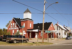 Golden Lake community centre and Post Office (K0J 1X0) | |
 North Algona Wilberforce | |
| Coordinates: 45°37′N 77°12′W / 45.617°N 77.200°WCoordinates: 45°37′N 77°12′W / 45.617°N 77.200°W | |
| Country | |
| Province | |
| County | Renfrew |
| Formed | January 1, 1999 |
| Government | |
| • Mayor | James Brose |
| • Federal riding | Renfrew—Nipissing—Pembroke |
| • Prov. riding | Renfrew—Nipissing—Pembroke |
| Area | |
| • Land | 378.98 km2 (146.32 sq mi) |
| Population (2016)[1] | |
| • Total | 2,915 |
| • Density | 7.7/km2 (20/sq mi) |
| Time zone | UTC-5 (EST) |
| • Summer (DST) | UTC-4 (EDT) |
| Postal Code | K0J 1T0 |
| Area code(s) | 613 |
| Website | www.nalgonawil.com |


North Algona Wilberforce is a township in Renfrew County, Ontario, Canada. It has a population of 2,873. The township was formed in 1999 when the North Algona and Wilberforce townships were amalgamated.
Wilberforce Township was named in 1851, to honour William Wilberforce.
Communities[]
The township contains the communities of Allans Corners, Beef Town, Budd Mills, Crooked Rapids, Deacon, Dore Bay, Duquette's Farm, Fourth Chute, Germanicus, Golden Lake, Green Lake, Higginson's Hill, Lake Dore, Lett's Corners, Mink Lake, Mud Lake, Rankin, Slabtown, Trevor Ouellette Lake and Woito.
The town of Fourth Chute is the fourth of five chutes (waterfalls) along the Bonnechere River. The others being Castleford, Renfrew, Douglas and Eganville.
Transportation[]
Canadian National Railway served Golden Lake on the Algonquin and Locksley subdivisions. Rail service was discontinued in 1961 on the Locksley Subdivision. The Algonquin Subdivision was broken in 1933 due to an unsafe trestle in the Algonquin Park at Cache Lake. The section east of the break became the Renfrew Subdivision, which maintained service until 1984. The grades of both lines now serve at trails for snow machines, ATVs and bicycles.
Demographics[]
| hideCanada census – North Algona Wilberforce community profile | |||
|---|---|---|---|
| 2016 | 2011 | 2006 | |
| Population: | 2915 (1.5% from 2011) | 2873 (1.2% from 2006) | 2840 (4.1% from 2001) |
| Land area: | 378.98 km2 (146.32 sq mi) | 378.53 km2 (146.15 sq mi) | 378.53 km2 (146.15 sq mi) |
| Population density: | 7.7/km2 (20/sq mi) | 7.6/km2 (20/sq mi) | 7.5/km2 (19/sq mi) |
| Median age: | 51.5 (M: 50.4, F: 52.5) | 45.9 (M: 45.2, F: 46.4) | |
| Total private dwellings: | 1752 | 1668 | 1624 |
| Median household income: | $50,038 | ||
| References: 2016[2] 2011[3] 2006[4] earlier[5] | |||
| Year | Pop. | ±% |
|---|---|---|
| 1996 | 2,595 | — |
| 2001 | 2,729 | +5.2% |
| 2006 | 2,840 | +4.1% |
| 2011 | 2,873 | +1.2% |
| 2016 | 2,915 | +1.5% |
| [6] | ||
Prior to amalgamation (1999):
- Total Population in 1996: 2,595
- North Algona: 664
- Wilberforce: 1,931
- Population in 1991:
- North Algona: 636
- Wilberforce: 1,792
Mother tongue:[1]
- English as first language: 92.5%
- French as first language: 2.9%
- English and French as first language: 0.0%
- Other as first language: 4.6%
See also[]
| Wikivoyage has a travel guide for North Algona Wilberforce. |
References[]
- ^ Jump up to: a b c "North Algona Wilberforce census profile". 2016 Census of Population. Statistics Canada. Retrieved 2019-02-25.
- ^ "2016 Community Profiles". 2016 Canadian Census. Statistics Canada. February 21, 2017. Retrieved 2019-02-25.
- ^ "2011 Community Profiles". 2011 Canadian Census. Statistics Canada. July 5, 2013. Retrieved 2012-02-13.
- ^ "2006 Community Profiles". 2006 Canadian Census. Statistics Canada. March 30, 2011. Retrieved 2012-02-13.
- ^ "2001 Community Profiles". 2001 Canadian Census. Statistics Canada. February 17, 2012.
- ^ Statistics Canada: 1996, 2001, 2006, 2011, 2016 census
| show Places adjacent to North Algona Wilberforce |
|---|

| Authority control |
|
|---|
- Lower-tier municipalities in Ontario
- Municipalities in Renfrew County
- Township municipalities in Ontario