North Bohemian Basin


The North Bohemian Basin (German: Nordböhmisches Becken, formerly also the Teplitz-Komotauer Becken), in Czech called more often the Most Basin (Czech: Mostecká pánev), is a landscape in North Bohemia (Czech Republic). It forms the south-western and central parts of the Ústí nad Labem Region. It is among the richest European deposits of lignite (brown coal), which has been extracted here since the second half of 19th century, mostly by extensive surface mining.
Adjacent landscapes[]
The basin lies between the Central and Eastern Ore Mountains to the north and the Rakovnik Highlands (Rakovnická pahorkatina) to the south. To the east the basin borders on the Central Bohemian Uplands and the foothills of Bohemian Switzerland as well as in the southeast on the landscape unit of the Lower Eger Table (Czech: Dolnooharská tabule, German: Untereger-Tafel). In the west it reaches the Doupov Mountains.
Gallery[]
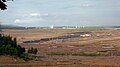
Lignite mine below

Infilling a mine near Most. In the foreground: the site of the old town


See also[]
References[]
- V. Cajz et al.: České Středohorí. Geologická a přírodovědná mapa Český geologický ústav, Prague 1996, ISBN 80-7075-238-6 (Das Böhmische Mittelgebirge, geologische Wanderkarte.).
- Ivo Chlupáč et al.: Geologická minulost České Republiky. Academia, Prague 2002, ISBN 80-200-0914-0.
- Josef Emanuel Hibsch: Erläuterungen zur Geologischen Karte der Umgebung von Brüx. Nákladem Stát. geologického ústavu ČSL. Rep., Prague 1929.
- Josef Emanuel Hibsch: Geologische Karte des Böhmischen Mittelgebirges. Blatt 7 (Teplitz-Boreslau) nebst Erläuterungen. Hölder, Vienna 1908.
- Josef Emanuel Hibsch: Geologische Karte des Böhmischen Mittelgebirges. Blatt 12 (Gartitz-Tellnitz) nebst Erläuterungen. Hölder, Vienna 1914.
- Roland Vinx (2008), Gesteinsbestimmung im Gelände (in German) (2 ed.), Heidelberg: Springer, ISBN 978-3-8274-1925-5
External links[]
Coordinates: 50°30′N 13°30′E / 50.500°N 13.500°E

| Authority control: National libraries |
|---|
- Regions of the Czech Republic
- Coal mining regions in the Czech Republic
- Drainage basins of the Czech Republic