North Carolina Highway 126
 | ||||
|---|---|---|---|---|
 | ||||
| Route information | ||||
| Maintained by NCDOT | ||||
| Length | 23.1 mi[1] (37.2 km) | |||
| Existed | 1940–present | |||
| Major junctions | ||||
| West end | ||||
| East end | ||||
| Location | ||||
| Counties | McDowell, Burke | |||
| Highway system | ||||
| ||||
| ||||
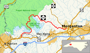
North Carolina Highway 126 (NC 126) is a primary state highway in the U.S. state of North Carolina. It runs from US 70, in Nebo, to NC 181, in Morganton.
Route description[]
NC 126 has changed little since it was established in 1940, thus the entire route has many curves as it bends around Lake James. It serves primarily to connect the people that live on the north side of Lake James to Marion and Morganton; secondary as a scenic route and access to Lake James State Park.
Scenic byways[]
Pisgah Loop Scenic Byway is a 47-mile (76 km) loop byway. The route is not recommended for recreational vehicles or buses, and four-wheel-drive vehicles are required for unpaved portions. NC 126 makes up the southern section of the byway (5 miles (8.0 km)). It is noted for being part of the "Overmountain Victory Trail Commemorative Motor Route" and nearby Lake James State Park. Other roads and highways that make-up the loop are: Fish Hatchery Road (SR 1254 & 1240), NC 181, NC 183, and Old NC Highway 105 (SR 1238, the entire road is unpaved).[2]
History[]
In 1933, NC 126 was established between US 258/NC 12, near Snow Hill, to US 17/NC 30 . It was quickly replaced by an extension of NC 102.[3]
The current NC 126 was established in 1940 as a renumbering of NC 105 from the community of Longtown[4] to the city of Morganton. In 1954, NC 126 was extended west, replacing NC 105's southern portion from Longtown to Nebo, while the northern section was decommissioned and exists today as unpaved road known as Old NC Highway 105.[3][5]
Major intersections[]
| County | Location | mi[1] | km | Destinations | Notes |
|---|---|---|---|---|---|
| McDowell | Nebo | 0.0 | 0.0 | Western terminus | |
| Burke | Morganton | 23.1 | 37.2 | Eastern terminus | |
| 1.000 mi = 1.609 km; 1.000 km = 0.621 mi | |||||
References[]
| ( • help)
|
| Wikimedia Commons has media related to North Carolina Highway 126. |
- ^ a b Google (April 27, 2015). "North Carolina Highway 126" (Map). Google Maps. Google. Retrieved April 27, 2015.
- ^ "NCDOT: Scenic Byways". Archived from the original on 2011-01-25. Retrieved 2011-01-06.
- ^ a b "NCRoads.com: N.C. 126". Archived from the original on November 25, 2010. Retrieved 2011-01-06.
- ^ "Longtown". Geographic Names Information System. United States Geological Survey. Retrieved 2011-01-06.
- ^ "NC State Hwy 126 Ends". Archived from the original on February 6, 2010. Retrieved 2011-01-06.
- State highways in North Carolina
- Transportation in McDowell County, North Carolina
- Transportation in Burke County, North Carolina
