North Carolina Highway 43
 | ||||
|---|---|---|---|---|
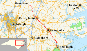 Route of NC 43 highlighted in red | ||||
| Route information | ||||
| Maintained by NCDOT | ||||
| Length | 119.6 mi[1] (192.5 km) | |||
| Existed | 1928–present | |||
| Major junctions | ||||
| South end | ||||
| ||||
| North end | ||||
| Location | ||||
| Counties | Craven, Pitt, Edgecombe, Nash, Halifax, Warren | |||
| Highway system | ||||
| ||||
| ||||
North Carolina Highway 43 (NC 43) is a primary state highway in the U.S. state of North Carolina. It connects many towns in the Coastal Plain region.
Route description[]
This section is empty. You can help by . (January 2012) |
History[]
NC 43 was established around 1928 as a new primary routing between US 17-1/NC 40, in Rocky Mount, and NC 58, in Liberia.[2] In 1931, NC 43 was extended southeast on new primary routing, through Pinetops, to Greenville; then replaced NC 301 to US 17/NC 30, in Vanceboro. Around 1936, NC 43 was rerouted onto new roadway at Essex, avoiding Hollister.[3] In 1958, NC 43 was rerouted in the downtown Greenville area, leaving behind: Charles Avenue, 10th Street, Albemarle Street and 5th Street.[4]
In 1987, NC 43 was extended south of Vanceboro along US 17 Business and US 17 to Weyerhaeuser Road. Traveling along Weyerhaeuser Road, it connects and overlap with NC 55 going into New Bern; then with US 70 Business and southward to US 70 and US 17. The resulting new routing made a western rural bypass of New Bern.[5] In 1998, NC 43 was rerouted onto new connector in downtown Rocky Mount.[6] In 2001, NC 43 was rerouted onto northern bypass route around Rocky Mount, leaving behind NC 43 Bus.[7] In 2009, NC 43 was rerouted onto new road between NC 55 and US 17/US 70, eliminating its routing through New Bern.[8]
Major intersections[]
| County | Location | mi[1] | km | Exit | Destinations | Notes |
|---|---|---|---|---|---|---|
| Craven | New Bern | 0.0– 0.3 | 0.0– 0.48 | Exit 411 (US 70) | ||
| 2.1 | 3.4 | |||||
| | 10.8 | 17.4 | Southern end of US 17 concurrency | |||
| | 14.3 | 23.0 | Northern end of US 17 concurrency; Southern end of US 17 Bus. Concurrency | |||
| Vanceboro | 16.4 | 26.4 | Northern end of US 17 Bus. Concurrency | |||
| 16.9 | 27.2 | Eastern terminus of NC 118 | ||||
| Pitt | Calico | 26.1 | 42.0 | |||
| Greenville | 40.3 | 64.9 | Southern end of US 264 Alt. concurrency | |||
| 42.6 | 68.6 | Northern end of US 264 Alt. concurrency; Southern end of NC 11/NC; 903 concurrency | ||||
| 44.5 | 71.6 | Southern end of US 13 concurrency | ||||
| 45.5 | 73.2 | Northern end of US 13/NC 11/NC 903 concurrencies | ||||
| | 48.0– 48.2 | 77.2– 77.6 | Exit 75 (US 264) | |||
| 52.4 | 84.3 | Northern terminus of NC 121 | ||||
| | 54.0 | 86.9 | Southern end of NC 222 concurrency | |||
| Falkland | 54.9 | 88.4 | Northern end of NC 222 concurrency | |||
| Edgecombe | | 61.9 | 99.6 | Western end of NC 42 concurrency | ||
| | 62.0 | 99.8 | Eastern terminus of NC 124 | |||
| | 63.2 | 101.7 | ||||
| Pinetops | 65.1 | 104.8 | ||||
| 65.3 | 105.1 | Northern end of NC 42 concurrency | ||||
| | 66.9 | 107.7 | ||||
| | 78.0 | 125.5 | Southern terminus of NC 43 Bus. | |||
| Rocky Mount | 80.1 | 128.9 | Southern end of US 64 Alt. concurrency | |||
| 80.4– 80.7 | 129.4– 129.9 | 472 | Northern end of US 64 Alt. concurrency; Southern end of US 64 concurrency; Eastern terminus of US 64 Bus. | |||
| 82.2– 82.4 | 132.3– 132.6 | 470 | ||||
| Nash | 82.8– 83.0 | 133.3– 133.6 | 469 | |||
| 83.4– 83.6 | 134.2– 134.5 | 468B | Northern end of US 64 concurrency; Southern end of NC 48 concurrency; Northern terminus of NC 43 Bus. | |||
| 84.1– 84.3 | 135.3– 135.7 | Interchange | ||||
| 84.8 | 136.5 | Northern end of NC 48 concurrency | ||||
| Dortches | 88.5– 88.7 | 142.4– 142.7 | Exit 141 (I-95) | |||
| Halifax | | 106.0 | 170.6 | Southern end of NC 561 concurrency | ||
| Essex | 108.0 | 173.8 | Northern end of NC 561 concurrency | |||
| Warren | Liberia | 119.6 | 192.5 | |||
1.000 mi = 1.609 km; 1.000 km = 0.621 mi
| ||||||
Special routes[]
Rocky Mount business loop[]
North Carolina Highway 43 Business | |
|---|---|
| Location | Rocky Mount, North Carolina |
| Length | 5.0 mi[9] (8.0 km) |
| Existed | 2001–present |
North Carolina Highway 43 Business (NC 43 Bus) was established in 2001, when NC 43 was rerouted to bypass north of downtown Rocky Mount. The business loop travels along Cokey Road, Fairview Road, Grand Avenue, Grace Street and Falls Road.[7]
Major intersections
| County | Location | mi[9] | km | Destinations | Notes |
|---|---|---|---|---|---|
| Edgecombe | | 0.0 | 0.0 | ||
| Rocky Mount | 2.7 | 4.3 | |||
| 3.5 | 5.6 | ||||
| Nash | 3.8 | 6.1 | |||
| 3.9 | 6.3 | Southern end of NC 48 concurrency (one way pair) | |||
| 5.0 | 8.0 | Exit 468B (US 64); Northern end of NC 48 concurrency | |||
1.000 mi = 1.609 km; 1.000 km = 0.621 mi
| |||||
In popular culture[]
North Carolina Highway 43 (NC 43) is used by people travelling to and from Mayberry on The Andy Griffith Show. Notable episodes that reference NC 43 are "Andy's English Valet", "Man In a Hurry" and "Gomer Saves the Day[10]".
References[]
- ^ a b Google (May 14, 2015). "North Carolina Highway 43" (Map). Google Maps. Google. Retrieved May 14, 2015.
- ^ State Highway System of North Carolina (PDF) (Map). Cartography by NCDOT. North Carolina Department of Transportation. 1930. Retrieved May 15, 2015.
- ^ North Carolina Primary Highway System (PDF) (Map). Cartography by NCDOT. North Carolina Department of Transportation. 1940. Retrieved May 15, 2015.
- ^ North Carolina Primary Highway System (PDF) (Map). Cartography by NCDOT. North Carolina Department of Transportation. 1960. Retrieved May 15, 2015.
- ^ "Route Change (1987-08-06)" (PDF). North Carolina Department of Transportation. August 6, 1987. p. 2. Retrieved May 15, 2015.
- ^ "Route Change (1998-07-31)" (PDF). North Carolina Department of Transportation. July 31, 1998. p. 2. Retrieved May 15, 2015.
- ^ a b "Route Change (2001-10-26)" (PDF). North Carolina Department of Transportation. October 26, 2001. Retrieved May 13, 2014.
- ^ "Route Change (2009-11-03)" (PDF). North Carolina Department of Transportation. November 3, 2009. p. 1. Retrieved May 15, 2015.
- ^ a b Google (May 14, 2015). "NC 43 Business - Rocky Mount, North Carolina" (Map). Google Maps. Google. Retrieved May 14, 2015.
- ^ Newsome, Originally Rick Bock and Gary Harvey...presently Allan. "The Andy Griffith Show - Interactive Storytelling: "Gomer Saves the Day"". www.imayberry.com. Retrieved 2016-12-24.
External links[]
| ( • help)
|
 Media related to North Carolina Highway 43 at Wikimedia Commons
- NCRoads.com: N.C. 43
- NCRoads.com: N.C. 43 Bus
- State highways in North Carolina
- Transportation in Craven County, North Carolina
- Transportation in Pitt County, North Carolina
- Transportation in Edgecombe County, North Carolina
- Transportation in Nash County, North Carolina
- Transportation in Halifax County, North Carolina
- Transportation in Warren County, North Carolina
