North Eastham, Massachusetts
North Eastham, Massachusetts | |
|---|---|
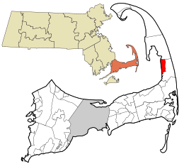 Location in Barnstable County and the state of Massachusetts. | |
| Coordinates: 41°51′5″N 70°00′00″W / 41.85139°N 70.00000°W | |
| Country | United States |
| State | Massachusetts |
| County | Barnstable |
| Town | Eastham |
| Area | |
| • Total | 11.9 sq mi (30.9 km2) |
| • Land | 3.4 sq mi (8.9 km2) |
| • Water | 8.5 sq mi (22.0 km2) |
| Elevation | 39 ft (12 m) |
| Population (2010) | |
| • Total | 1,806 |
| • Density | 526/sq mi (203.0/km2) |
| Time zone | UTC-5 (Eastern (EST)) |
| • Summer (DST) | UTC-4 (EDT) |
| ZIP code | 02651 |
| Area code(s) | 508 |
| FIPS code | 25-47590 |
| GNIS feature ID | 0616892 |

North Eastham is a census-designated place (CDP) in the town of Eastham in Barnstable County, Massachusetts, United States. The population was 1,806 at the 2010 census.[1]
The main visitor center of the Cape Cod National Seashore is located in North Eastham.[verification needed]
Geography[]
North Eastham is located within the northwestern part of the Town of Eastham at 41°51′05″N 70°00′00″W / 41.851349°N 69.999928°WCoordinates: 41°51′05″N 70°00′00″W / 41.851349°N 69.999928°W (41.851349, −69.999928).[2] It is bordered to the west by Cape Cod Bay, to the north by the town of Wellfleet, to the east by U.S. Route 6 and Great Pond Road, and to the south by Great Pond, Herring Brook Road, and Samoset Road.[verification needed]
According to the United States Census Bureau, the CDP has a total area of 11.9 square miles (30.9 km2). 3.4 square miles (8.9 km2) of it is land, and 8.5 square miles (22.0 km2) of it (71.24%) is water.[1]
Demographics[]
At the 2000 census there were 1,915 people, 881 households, and 570 families in the CDP. The population density was 217.5/km2 (562.4/mi2). There were 2,656 housing units at an average density of 301.6/km2 (780.1/mi2). The racial makeup of the CDP was 98.12% White, 0.26% African American, 0.16% Native American, 0.42% Asian, 0.05% Pacific Islander, 0.05% from other races, and 0.94% from two or more races. Hispanic or Latino of any race were 0.84%.[3]
Education[]

Nauset Public Schools serves the community.
Nauset Regional High School is the area high school.
See also[]
References[]
- ^ a b "Geographic Identifiers: 2010 Demographic Profile Data (G001): North Eastham CDP, Massachusetts". U.S. Census Bureau, American Factfinder. Archived from the original on February 12, 2020. Retrieved December 10, 2013.
- ^ "US Gazetteer files: 2010, 2000, and 1990". United States Census Bureau. 2011-02-12. Retrieved 2011-04-23.
- ^ "U.S. Census website". United States Census Bureau. Retrieved 2008-01-31.
External links[]

- Census-designated places in Barnstable County, Massachusetts
- Eastham, Massachusetts
- Census-designated places in Massachusetts
- Populated coastal places in Massachusetts