North Klawatti Glacier
| North Klawatti Glacier | |
|---|---|
 North Klawatti Glacier | |
 North Klawatti Glacier Location in Washington | |
| Type | Valley glacier |
| Location | North Cascades National Park, Skagit County, Washington, U.S. |
| Coordinates | 48°33′55″N 121°04′39″W / 48.56528°N 121.07750°WCoordinates: 48°33′55″N 121°04′39″W / 48.56528°N 121.07750°W[1] |
| Length | 1.4 mi (2.3 km) |
| Terminus | Icefall |
| Status | Retreating |

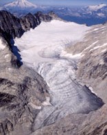
North Klawatti Glacier lies in a cirque to the east of Austera Peak, North Cascades National Park, in the U.S. state of Washington.[2] The glacier is approximately 1.4 mi (2.3 km) in length, .40 mi (0.64 km) in width at its widest and descends from 7,800 to 6,000 ft (2,400 to 1,800 m), where it terminates above Klawatti Lake. An arête divides North Klawatti Glacier from Klawatti Glacier to the south.[2] The North Klawatti Glacier was one of four glaciers selected for glacier mass balance research.[3]
See also[]
References[]
- ^ "North Klawatti Glacier". Geographic Names Information System. United States Geological Survey. Retrieved 2013-02-09.
- ^ a b Forbidden Peak, WA (Map). TopoQwest (United States Geological Survey Maps). Retrieved 2013-02-09.
- ^ "Glacier Monitoring Program". National Park Service. Retrieved 2013-02-09.
This article about a glacier in Washington is a stub. You can help Wikipedia by . |
Categories:
- Glaciers of the North Cascades
- Glaciers of Skagit County, Washington
- Glaciers of Washington (state)
- Washington (state) glacier stubs