North Pagai
Native name: Pagai Utara | |
|---|---|
 | |
| Geography | |
| Location | South East Asia |
| Coordinates | 2°42′S 100°5′E / 2.700°S 100.083°E |
| Archipelago | Mentawai Islands |
| Area | 342.02 km2 (132.05 sq mi) |
| Administration | |
Indonesia | |
| Province | West Sumatra |
| Regency | Mentawai Islands |
| Demographics | |
| Population | 6,055 (2019 estimate) |
| Pop. density | 17.7/km2 (45.8/sq mi) |
| Ethnic groups | Mentawai |

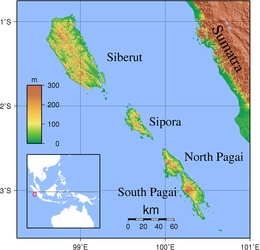
North Pagai (Indonesian: Pagai Utara) is the smallest of the four principal Mentawai Islands off the west coast of Sumatra in Indonesia. It is south of Sipora and north of South Pagai (or Pagai Selatan) Island.
The area and population figures given for North Pagai in the box to the right are for North Pagai District alone. They exclude the main part of Sikakap District which covers the southern part of North Pagai Island and the northern part of South Pagai Island, together with various small islands in the strait between the two. The town of Sikakap was used as a centre for relief operations related to the 2010 Mentawai earthquake and tsunami.[1]
Surf breaks[]
- Silabus
- Macca's
- Macca's Right
- Bommie Peak
- Gilligans
References[]
- ^ Weaver, Matthew (2010-10-27). "Race is on to save 500 victims of Indonesia double disaster". The Guardian. London: GMG. ISSN 0261-3077. OCLC 60623878. Retrieved 2010-10-27.
- Lonely Planet: - page 437
This West Sumatra location article is a stub. You can help Wikipedia by . |
This article about an Indonesian sports venue is a stub. You can help Wikipedia by . |
- Mentawai Islands Regency
- Islands of Sumatra
- Islands of the Indian Ocean
- Surfing locations in Indonesia
- Sumatra geography stubs
- Indonesian sports venue stubs