Northern Region (Ghana)
Northern Region | |
|---|---|
 Tamale Stadium | |
 Location of Northern Region in Ghana | |
| Country | Ghana |
| Capital | Tamale |
| Districts | 14 |
| Government | |
| • Regional Minister | Salifu Saeed[1] |
| Area | |
| • Total | 70,384 km2 (27,175 sq mi) |
| Population (2010 Census)[3] | |
| • Total | 2,479,461 |
| • Density | 35/km2 (91/sq mi) |
| GDP (PPP) | |
| • Year | 2013 |
| • Per capita | $5,150 |
| GDP (Nominal) | |
| • Year | 2018 |
| • Per capita | $2,500 |
| Time zone | GMT |
| Area code(s) | 037 |
| ISO 3166 code | GH-NP |
| HDI (2017) | 0.494[4] low · 10th |
The Northern Region is one of the sixteen regions of Ghana.[5] It is located in the north of the country and was the largest of the sixteen regions, covering an area of 70,384 square kilometres or 31 percent of Ghana's area until December 2018 when the Savannah Region and North East Region were created from it. The Northern Region is divided into 14 districts. The region's capital is Tamale.[2]
Geography and climate[]
Location and size[]
The Northern Region is bordered on the north by the North East region, on the east by the eastern Ghana-Togo international border, on the south by the Oti region, and on the west by the Savannah Region. Northern region is made up of 14 districts.
Climate and vegetation[]
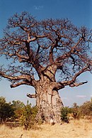
The Northern Region is much drier than southern areas of Ghana, due to its proximity to the Sahel, and the Sahara. The vegetation consists predominantly of grassland, especially savanna with clusters of drought-resistant trees such as baobabs or acacias. Between January and March is the dry season. The wet season is between about July and December with an average annual rainfall of 750 to 1050 mm (30 to 40 inches). The highest temperatures are reached at the end of the dry season, the lowest in December and January. However, the hot Harmattan wind from the Sahara blows frequently between December and the beginning of February. The temperatures can vary between 14 °C (59 °F) at night and 40 °C (104 °F) during the day.
Economy[]

More than 75% of the economically active population are agricultural. The low population density is partly caused by emigration, in addition to geography and climate.
Demographics[]
The Northern Region has a low population density, and, along with the official language of English, most inhabitants (52%) speak a language of the Oti–Volta subfamily in the Niger–Congo language family, such as Dagbani, Mamprusi or Konkomba. The Dagbon Kingdom, of the Dagomba people, is located in the region.
Tourist and Attraction[]
- Naa Gbewaa Palace, Yendi
- Saakpoli Slaves wells
- Diarre Napagaduungbanani
- Naa Binbegu Boabab Tree, Yendi
- Buntaga Irrigation Dam
- Sabali (River Oti)
- Nawuni River (White Volta)
Religion[]
Around three out of five residents in the Northern region were affiliated to Islam (60.0%).[6]
Districts[]

The Northern Region of Ghana contains 16 districts. 11 are ordinary districts in addition to 1 metropolitan and 4 municipal districts.:[7]
| # | District | Capital | Population |
|---|---|---|---|
| 1 | Gushegu | Gushegu | |
| 2 | Karaga | Karaga | |
| 3 | Kpandai | Kpandai | 108,816 |
| 4 | Kumbungu | Kumbungu | |
| 5 | Mion | Sang | |
| 6 | Nanton | Nanton | |
| 7 | Nanumba North | Bimbilla | |
| 8 | Nanumba South | Wulensi | |
| 9 | Saboba[8] | Saboba | |
| 10 | Sagnarigu | Sagnerigu | |
| 11 | Savelugu | Savelugu | |
| 12 | Tamale Metropolitan | Tamale | |
| 13 | Tatale Sangule | Tatale | |
| 14 | Tolon | Tolon | |
| 15 | Yendi Municipal District | Yendi | |
| 16 | Zabzugu | Zabzugu |
Some famous citizens[]
| # | Citizen | Settlement |
|---|---|---|
| 1 | Aliu Mahama | Yendi |
| 2 | Wakaso | Tamale |
| 3 | Majeed Waris | Tamale |
| 4 | Haruna Iddrisu | Tamale |
| 5 | Muhammad Mumuni | Kumbungu |
| 6 | Ramatu Baba | Yendi |
| 5 | Yendi |
References[]
- ^ "Regional Ministers - Government of Ghana". ghana.gov.gh. Archived from the original on 4 July 2017. Retrieved 23 March 2018.
- ^ Jump up to: a b "Northern Region". GhanaDistricts.com. Archived from the original on 2010-02-11. Retrieved 2009-11-20.
- ^ "Northern Region – Population" (PDF). statsghana.gov.gh. Archived from the original (PDF) on 2013-09-25. Retrieved 2013-01-20.
- ^ "Sub-national HDI - Area Database - Global Data Lab". hdi.globaldatalab.org. Retrieved 2018-09-13.
- ^ "No new Covid-19 cases in Northern Region in 3 weeks - MyJoyOnline.com". www.myjoyonline.com. Retrieved 2021-05-18.
- ^ "Table 4.17: Population by religious affiliation and region, 2010" (PDF). Archived from the original (PDF) on 2018-07-12. Retrieved 2018-07-17.
- ^ "Northern". GhanaDistricts.com. Archived from the original on 18 January 2013. Retrieved 15 January 2013.
- ^ "Victims of land conflict in Saboba district pick up their pieces - MyJoyOnline.com". www.myjoyonline.com. Retrieved 2021-05-18.
- "Districts of Ghana". Statoids.
- GhanaDistricts.com
External links[]
| show Places adjacent to Northern Region (Ghana) |
|---|

Coordinates: 9°30′N 1°00′W / 9.500°N 1.000°W

| show Authority control |
|---|
- Northern Region (Ghana)
- Regions of Ghana
- Dagbon