Norwegian County Road 13
 | |
|---|---|
| Old number: 13 | |
  Location of the road | |
| Route information | |
| Length | 80 km (50 mi) |
| Major junctions | |
| North end | |
| South end | |
| Location | |
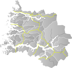
| Counties | Vestland |
| Major cities | Balestrand, Holsen, Moskog |
| Highway system | |
| |
County Road 13 (Norwegian: Fylkesvei 13) did run between the village of Dragsvik in Sogndal Municipality and the village of Moskog in Sunnfjord Municipality in Vestland county, Norway.
Until 2010, the 80-kilometre (50 mi) long road was part of National Road 13 but administrative reforms passed this part of the road to the county. County Road 13 and a short section of County Road 55 are designated as one of eighteen National Tourist Routes in Norway. The road crosses the Gaularfjellet mountains.[1][2]
In 2019, the road was renumbered to County Road 613, as a part of a reform aiming to have separate numbers of National Roads and County Roads. After this only National Road 13 has number 13 in Norway.
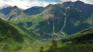
Gaularfjell

Rørvikfjellet


Route[]
Sunnfjord municipality
 E39
E39  Moskog
 Jølstra (ca. 50 m)
 to Haukedalen
 Vallestad waterfall
 at the village of Vik
- Soget (ca. 60 m)
- Osen (ca. 60 m)
 to Hestad
 Closed going east of Mjell at night in winters
Sogndal municipality
- Nystølen
 Elevation: 745 metres (2,444 ft) (highest point on this road)
 - Closed going north of Mel at night in winters
 to Menes
 (180 m)
- (180 m)

 Fv55 to Tjugum and Balestrand
 at Dragsvik, connections to
  Rv13
Rv13  Fv55
Fv55
References[]
| Wikimedia Commons has media related to Fylkesveg 613. |
- ^ "Nasjonal turistveg Gaularfjellet" (in Norwegian). Norwegian Public Roads Administration. Archived from the original on 5 October 2011. Retrieved 5 October 2011.
- ^ "Gaularfjellet". Norwegian Public Roads Administration. Archived from the original on 5 October 2011. Retrieved 5 October 2011.
National Tourist Routes | ||
|---|---|---|
|  | |
- County roads in Vestland
- Former Norwegian national roads
- National Tourist Routes in Norway
- Sunnfjord
- Sogndal