Nufenen Pass
| Nufenen Pass | |
|---|---|
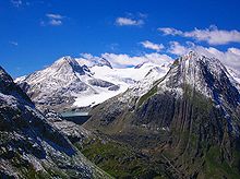
 View from the pass towards the Bernese Alps with the Finsteraarhorn (left) and Lauteraarhorn (right) | |
| Elevation | 2,478 m (8,130 ft)[1] |
| Traversed by | Road |
| Location | Ticino/Valais, Switzerland |
| Range | Alps |
| Coordinates | 46°28′41″N 08°23′35″E / 46.47806°N 8.39306°ECoordinates: 46°28′41″N 08°23′35″E / 46.47806°N 8.39306°E |
 Nufenen Pass Location in Switzerland | |
Nufenen Pass (Italian: Passo della Novena, German: Nufenenpass) (el. 2478 m.) is the highest mountain pass with a paved road within Switzerland. It lies between the summits of Pizzo Gallina (north) and the Nufenenstock (south).
The pass road from Ulrichen in canton of Valais leads to the Bedretto valley in the canton of Ticino, linking Brig to Airolo. It is not the lowest pass between the two valleys, as it is located one kilometre north of an unnamed slightly lower pass at 2,440 metres (vs 2478 m.), which is traversed by a trail.
The road is of relatively recent construction, having been opened to motor vehicle traffic only since September 1969.[2]
The source of the Ticino River lies east of the top of the pass. Towards the north are views of the Bernese Alps, including the Finsteraarhorn while there is a view over the Gries Glacier to the south.


See also[]
- List of highest paved roads in Europe
- List of mountain passes
Bibliography[]
- Nicola Pfund, Sui passi in bicicletta - Swiss Alpine passes by bicycle, Fontana Edizioni, 2012, p. 54-61. ISBN 978-88-8191-281-0
Sources and further reading[]
- This article incorporates information from the equivalent article in the German Wikipedia, consulted during April 2009.
External links[]
| Wikimedia Commons has media related to Nufenen Pass. |
- Cycling Map, Elevation Profile, and Photos
- Profile on climbbybike.com
- Cycling up to the Nufenenpass: data, profile, map, photos and description
- Mountain passes of Ticino
- Mountain passes of the Alps
- Mountain passes of Valais
- Ticino–Valais border
- Valais geography stubs
- Ticino geography stubs
