Nukhayb
Coordinates: 32°2′28″N 42°15′17″E / 32.04111°N 42.25472°E
An Nukhayb
النخيب | |
|---|---|
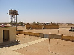
 View of town from the roof of the school | |
 An Nukhayb | |
| Coordinates: 32°2′28″N 42°15′17″E / 32.04111°N 42.25472°E | |
| Country | |
| Governorate | Anbar Governorate |
| District | Ar-Rutba District |
| Population (2015) | |
| • Total | ~4,000 |
| Time zone | UTC+3 (GMT+3) |
| Postal code | 31016 |
An Nukhayb (Arabic: النخيب, alt. Nukhaib, Nkheeb) is a town in Al Anbar Governorate, Iraq. Prior to the 1940s and during a short period in the 1970s, the town was administered by the Karbala Governorate. There has been conflict regarding to which governorate the town should belong.[1][2]
Nukhayb is located on the Al-Abyad Wadi at the largest road junction in the region, with roads going south to the Saudi Arabian border, north to the Ramadi–Jordan highway, and northeast to Karbala. Nukhayb is the last Iraqi town before pilgrims cross into Saudi Arabia on their pilgrimage to Mecca. It has two satellite villages to the north, Habbariya (28 km) and Kesrah (51 km).[3]
History[]
During the British Mandate, John Bagot Glubb established a post at the well of Nukhayb to allow the Iraqi government to control its western deserts.[4]: 342 Throughout 1929, sections of the Royal Air Force Armoured Cars served outpost duty in Nukhayb.[5]

In 1960, Nukhayb was upgraded from village to subdistrict.
In 2010, Qatari royal Khalifa bin Abdulla bin Hassan bin Ali al-Thani was killed in Nukhayb when his GMC hit a bump and rolled during a hunting trip.[6]
In September 2011, 22 Shia pilgrims en route from Damascus to Karbala were stopped at a fake checkpoint near Nukhayb, and then killed by gunmen.[7][8] In another false checkpoint attack, 14 Iraqi border guards were killed by militants in June 2013.[9]
Reports in summer of 2014 indicated that the Iraqi Army and the Islamic State of Iraq and the Levant (ISIS) clashed in the town, with government troops "fleeing" towards Karbala.[10] ISIS was reported as having taken control of the town in late June of that year;[11] the Iraqi government forces stated that they regained control of the town in late August of that year.[12]
Climate[]
In Nukhayb, there is a desert climate. Most rain falls in the winter. The Köppen-Geiger climate classification is BWh. The average annual temperature in Nukhayb is 21.6 °C (70.9 °F). About 57 mm (2.24 in) of precipitation falls annually.
| Climate data for Samawah | |||||||||||||
|---|---|---|---|---|---|---|---|---|---|---|---|---|---|
| Month | Jan | Feb | Mar | Apr | May | Jun | Jul | Aug | Sep | Oct | Nov | Dec | Year |
| Average high °C (°F) | 15.4 (59.7) |
18.1 (64.6) |
22.8 (73.0) |
27.8 (82.0) |
33.8 (92.8) |
39.6 (103.3) |
41.7 (107.1) |
41.6 (106.9) |
38.2 (100.8) |
31.2 (88.2) |
23.2 (73.8) |
17.4 (63.3) |
29.2 (84.6) |
| Average low °C (°F) | 3.0 (37.4) |
4.6 (40.3) |
8.0 (46.4) |
13.1 (55.6) |
18.5 (65.3) |
22.4 (72.3) |
24.5 (76.1) |
24.0 (75.2) |
20.5 (68.9) |
15.8 (60.4) |
9.5 (49.1) |
3.6 (38.5) |
14.0 (57.1) |
| Average precipitation mm (inches) | 19 (0.7) |
11 (0.4) |
4 (0.2) |
5 (0.2) |
4 (0.2) |
0 (0) |
0 (0) |
0 (0) |
1 (0.0) |
3 (0.1) |
6 (0.2) |
4 (0.2) |
57 (2.2) |
| Source: Climate-Data.org,Climate data | |||||||||||||
References[]
- ^ Turki, Ibrahim. "Battle For The Iraqi Outback Town On A Cultural Crossroads". Niqash.
- ^ "Fears of fresh outbreak of sectarian violence grip Iraq". The National.ae.
- ^ Bajallat Markaz Buḥūth Al-Tārīkh Al-Ṭabīʻī. The Center. 1975. Retrieved 15 September 2013.
- ^ Sir John Bagot Glubb (1960). War in the desert: an R. A. F. frontier campaign. Hodder and Stoughton. Retrieved 15 September 2013.
- ^ "RAF Armoured Car Companies in Iraq, 1920-1945". RAFAC Iraq (pg 1929). Retrieved 26 September 2014.
- ^ "Qatar royal killed in car crash in Iraq". Khaleej Times. 6 November 2010.
- ^ "Criminals behind Nikhaib massacre confess in front of media". All Iraq News. Archived from the original on 2014-09-26.
- ^ "Iraqi police: Gunmen ambush Shiite pilgrims, killing 22". CNN. 12 September 2011.
- ^ "14 Iraqi border police gunned down at fake checkpoint, 2 bodies burned". Agence France-Presse. June 5, 2013. Retrieved 4 January 2015.
- ^ "Iraq denies withdrawal of forces from Saudi border". BBC News. 3 July 2014. Retrieved 26 September 2014.
- ^ Erdbrink, Thomas (26 June 2014). "In the Shadows of Shrines, Shiite Forces Are Preparing to Fight ISIS". New York Times. Retrieved 26 September 2014.
- ^ al-Obaidi, Hassan (26 August 2014). "Iraqi forces drive ISIL from 3 Anbar cities". Al Shorfa. Retrieved 22 November 2014.
Further reading[]
- Sarhan, Abbas. Karbala and Anbar dispute forgotten town. Niqash, 3 June 2009
- Visser, Reidar. Disputed Territories in Iraq: The Practical Argument Against Self-Determination in Kirkuk. historiae.org. 25 May 2009
- K. M. Al Naqib (1949). "Geology of the Arabian Peninsula, Southwestern Iraq". Geological Survey Professional Paper. U.S. Government Printing Office. pp. 606–.
- D. C. P. Thalen (1979). Ecology and utilization of desert shrub rangelands in Iraq. W. Junk. Retrieved 15 September 2013.
- Populated places in Al Anbar Governorate
- Subdistricts of Iraq
