Nyayo House
| Nyayo House | |
|---|---|
 Nyayo House, Nairobi | |
 | |
| General information | |
| Type | Government Building |
| Location | Nairobi, Kenya |
| Technical details | |
| Floor count | 24 |
| Design and construction | |
| Main contractor | Laxmanbhai Construction |
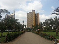
Nyayo House is a skyscraper in Nairobi, Kenya. It hosts several government departments such as immigration (the ) and also serves as the headquarters of Nairobi Province. The building is located at the corner of and .[1] It is 84 metres high and has 27 floors[2]
Planning of the tower started in 1973 and it was initially set to be named as Nairobi House. Construction started in 1979, one year after Daniel arap Moi took over as the president of Kenya. Building of the house was completed in 1983. The building was planned by Ministry of Public Works, Ngotho Architects and constructed by Laxmanbhai Construction.[1]
Nyayo House is particularly known for its detention facilities in its basement, often called as "Nyayo House torture chambers". Many opponents of the Moi government were beaten there by Special Branch officials (the Special Branch was later renamed the National Security Intelligence Service).[1] Some of the known detainees at Nyayo House were George Anyona, Wahome Mutahi and Raila Odinga[3]
After the Moi era the (TJRC) investigated Nyayo House torture cases and several victims, including politician Koigi wa Wamwere have been compensated.[1] Another detainee, musician died soon after he was released, allegedly due to injuries caused by torture.[4] The former torture chambers have now been opened to the general public.[1]
Nyayo House is also infamous for the amount for corruption by various state officials.[1]
Gallery[]

References[]
| Wikimedia Commons has media related to Nyayo House. |
- ^ a b c d e f "Inside the walls of the house that kept Kenya's dark secrets". Daily Nation. 5 May 2012.
- ^ "Nyayo House, Nairobi". SkyscraperPage.com. Retrieved 16 April 2014.
- ^ "We lived to tell – The Nyayo House Story" (PDF). Retrieved 16 April 2014.
- ^ "Cells may have been part of Nyayo House plan". Standardmedia.co.ke.

- Government buildings completed in 1983
- Buildings and structures in Nairobi
- Skyscraper office buildings in Kenya
- 1980s in Nairobi