Oberwald
This article includes a list of references, related reading or external links, but its sources remain unclear because it lacks inline citations. (December 2015) |
Oberwald | |
|---|---|
 | |
 Coat of arms | |
show Location of Oberwald | |
 Oberwald | |
| Coordinates: 46°32′N 8°21′E / 46.533°N 8.350°ECoordinates: 46°32′N 8°21′E / 46.533°N 8.350°E | |
| Country | Switzerland |
| Canton | Valais |
| District | Goms |
| Municipality | Obergoms |
| Area | |
| • Total | 969 km2 (374 sq mi) |
| Elevation | 1,377 m (4,518 ft) |
| Population (2007-12-31) | |
| • Total | 277 |
| • Density | 0.29/km2 (0.74/sq mi) |
| Time zone | UTC+01:00 (Central European Time) |
| • Summer (DST) | UTC+02:00 (Central European Summer Time) |
| Postal code(s) | 3999 |
| SFOS number | 6066 |
| Localities | Gletsch |
| Website | www |


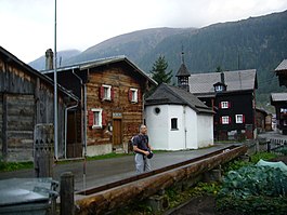
Oberwald is a village in the municipality of Obergoms in Goms District in the canton of Valais in Switzerland.
It is situated at an elevation of 1,377 m and had a population of 277 in December 2007.[citation needed] It is located at the end of the Goms, directly before the Furka and Grimsel passes, underneath the Rhône River source at the Rhône Glacier. It is also the startpoint of the Furka Tunnel. Most inhabitants live off tourism or sheep farming.
Oberwald was an independent municipality until January 1, 2009, when it merged with Ulrichen and Obergesteln to form the municipality of Obergoms.
References[]
External links[]
| Wikimedia Commons has media related to Oberwald. |
| show Authority control |
|---|
Categories:
- Former municipalities of Valais
- Ski areas and resorts in Switzerland
- Populated places on the Rhône