Odenbach (Glan)
| Odenbach | |
|---|---|
| Location | |
| Location | North French Scarplands
|
| Reference no. | DE: 25468 |
| Physical characteristics | |
| Source | |
| • location | South of Schneckenhausen near the hamlet of |
| • coordinates | 49°32′1.20″N 7°44′39.60″E / 49.5336667°N 7.7443333°ECoordinates: 49°32′1.20″N 7°44′39.60″E / 49.5336667°N 7.7443333°E |
| • elevation | ca. 332 m above sea level (NHN) [1] |
| Mouth | |
• location | In Odenbach from the right into the Glan |
• coordinates | 49°40′58.29″N 7°38′58.73″E / 49.6828583°N 7.6496472°E |
• elevation | ca. 152 m above sea level (NHN) [1] |
| Length | 22.72 km (14.12 mi)[2] |
| Basin size | 85.956 km2 (33.188 sq mi)[2] |
| Basin features | |
| Progression | Glan→ Nahe→ Rhine→ North Sea |

The Odenbach is a 22.7-kilometre-long (14.1 mi) orographically right bank tributary of the Glan in the counties of Kaiserslautern and Kusel in the German state of Rhineland-Palatinate.
Geography[]
Course[]
The Odenbach rises about 8 km (5.0 mi) north of Kaiserslautern in the North Palatine Uplands near the hamlet of . It flows – mainly in a north-northwesterly direction – through the municipalities of Schneckenhausen, Schallodenbach and Niederkirchen in the county of Kaiserslautern and through Hefersweiler, Reipoltskirchen, Ginsweiler and Adenbach in the county of Kusel, before emptying into the Glan in the eponymous village of Odenbach after a distance of just under 23 kilometres.
Catchment[]
The catchment of the Odenbach covers an area of 85.956 km2 (33.188 sq mi) and consist of 50% arable land, 25.6% pasture, 20.2% woodland and 4.2% settlements.[3]
Unable to compile EasyTimeline input:
Timeline generation failed: 4 errors found
Line 11: id:Wald value:teal legend:20,2_% Waldfläche
- Invalid attribute 'Waldfläche' ignored.
Specify attributes as 'name:value' pairs.
Line 12: id:Acker value:yelloworange legend:50,0_% Ackerland
- Invalid attribute 'Ackerland' ignored.
Specify attributes as 'name:value' pairs.
Line 13: id:Wiese value:green legend:25,6_% Grünland
- Invalid attribute 'Grünland' ignored.
Specify attributes as 'name:value' pairs.
Line 14: id:Orte value:red legend: 4,2_% Siedlungsbereich
- Invalid attribute 'Siedlungsbereich' ignored.
Specify attributes as 'name:value' pairs.
Tributaries[]
The most important tributary of the Odenbach is the , which alone drains 21% of the catchment of the Odenbach. The other streams have a catchment of less than 10 km2 (3.9 sq mi).
The following table shows the tributaries of the Odenbach from source to mouth, as listed by the Water Management Authority of Rhineland-Palatinate. The table gives the name, whether it is a left or right tributary,[1] its length,[2] its catchment area,[2], the location of its confluence, the height of its confluence[1] and its waterbody number.[2]
| Name | Left/right tributary | Length [km] |
Catchment [km²][2] |
Distance from mouth [km][4] |
Height at confluence [m above sea level] |
GKZ |
|---|---|---|---|---|---|---|
| left | 0.7 | 0.415 | West of Schneckenhausen | 326 | 25468-1112 | |
| right | 2.2 | 2.205 | On the western edge of Schneckenhausen | 319 | 25468-112 | |
| (stream from) Gorrhof | left | 0.5 | 0.222 | Between Schneckenhausen and Schallodenbach | 314 | 25468-1192 |
| [Z 1][Z 2] | right | 0.8 | 0.535 | Between Schneckenhausen and Schallodenbach | 313 | 25468-1194 |
| right | 1.0 | 0.781 | East of Schallodenbach | 308 | 25468-12 | |
| (stream from the) source | left | 0.4 | 0.198 | East of Schallodenbach | 304 | 25468-132 |
| right | 0.9 | 0.825 | West of Schallodenbach | 301 | 25468-134 | |
| left | 1.0 | 0.618 | Northwest of Schallodenbach | 292 | 25468-136 | |
| left | 0.9 | 0.742 | Between Schallodenbach and Niederkirchen- | 290 | 25468-14 | |
| Wörsbach | left | 1,4 | 1,584 | südlich von Wörsbach-Rauschermühle | 281 | 25468-16 |
| Lenzelbach[Z 3][Z 4] | left | 0.5 | Near Wörsbach-Rauschermühle | 281 | 25468-1912 | |
| right | 1.7 | 0,349 | NNE of Wörsbach-Rauschermühle | 265 | 25468-1914 | |
| (stream from the) Flachsgarten | left | 0.1 | 0.410 | S of Niederkirchen | 261 | 25468-1916 |
| [Z 3][Z 5] | right | 0.3 | 0.687 | S of Niederkirchen | 260 | 25468-1918 |
| (Bellenmühlbach)[Z 6] | left | 2.4 | 2.984 | In Niederkirchen | 259 | 25468-192 |
| right | 4.2 | 9.879 | In Niederkirchen | 259 | 25468-2 | |
| [Z 7][Z 8][Z 9][Z 10] | left | 1.2 | 0.777 | NW of Niederkirchen | 241 | 25468-31129 |
| right | 0.6 | 0.431 | NE of Niederkirchen- | 240 | 25468-312 | |
| left | 0.3 | 0.232 | NW of Niederkirchen-Bügenmühlerhof | 240 | 25468-3192 | |
| left | 3.1 | 3.385 | in Niederkirchen-Morbach | 236 | 25468-32 | |
| [Z 11][Z 12] | right | 1.8 | 1.42 | SSW of Seelen | 233 | 25468-3?? |
| left | 0.5 | 0.214 | S of Hefersweiler | 225 | 25468-392 | |
| left | 1.9 | 1.973 | In Hefersweiler | 224 | 25468-4 | |
| right | 1.1 | 0.690 | W of Hefersweiler- | 221 | 25468-512 | |
| left | 1.7 | 1.127 | NE of Hefersweiler- | 216 | 25468-52 | |
| right | 1.0 | 0.665 | SSE of Reipoltskirchen- | 211 | 25468-592 | |
| left | 0.4 | 0.106 | Opposite Ingweilerhof | 210 | 25468-594 | |
| right | 7.4 | 18.468 | SE of Reipoltskirchen | 199 | 25468-6 | |
| left | 3.0 | 2.636 | In Reipoltskirchen | 199 | 25468-72 | |
| [Z 13] | left | 1.3 | NW of Reipoltskirchen | 187 | ||
| Schlappenrecher Graben | right | NW of Reipoltskirchen | ||||
| right | 2.5 | 4.305 | W of Ginsweiler | 177 | 25468-8 | |
| [Z 12] | left | 0.6 | 0.96 | E of Adenbach- | 170 | 25468-91? |
| right | 2.6 | 2.451 | W edge of Adenbach | 166 | 25468-92 | |
| right | 0.3 | 0.425 | In Odenbach | 155 | 25468-9992 |
Transport routes[]
The L 201 runs through the Odenbach valley.
Leisure pursuits[]
The Odenbach Valley Cycleway runs through the Odenbach valley for 31.5 kilometres (19.6 mi). It runs from Otterberg via Niederkirchen to Odenbach[5][6]
Sights[]
The best known sights in the valley are the two water castles:

- Reipoltskirchen Castle, built in the 12th century, lies on a rocky hill spur above the Odenbach. It was the seat of the lords of Hohenfels-Reipoltskirchen and is first recorded in 1276. The site has largely survived and been restored. It is used by the municipality of Reipoltskirchen inter alia as the Standesamt. Its bergfried is used by tourists as an observation tower.
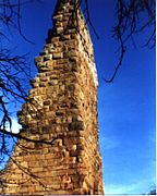

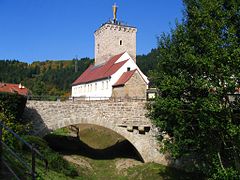
- , at the confluence of the river with the Glan, was built in the 2nd half of the 12th century by the counts of Veldenz and blown up in 1683 by troops of the French king, Louis XIV. The ruins include the renovated remains of the bergfried, which is built of impressive rusticated ashlar blocks and, as the Weiherturm, has become the symbol of the village of Odenbach.
See also[]
References[]
- ^ a b c d Map service of the Landscape Information System of the Rhineland-Palatinate Nature Conservation Office (Naturschutzverwaltung Rheinland-Pfalz)
- ^ a b c d e f Geoexplorer of the Rhineland-Palatinate Water Authority (Wasserwirtschaftsverwaltung Rheinland-Pfalz)
- ^ Gewässerzustandsbericht 2010, Struktur- und Genehmigungsdirektion Nord (SGD Nord)
- ^ Measurement based on German terrain maps (Deutscher Grundkarte) 1:5000 series
- ^ Odenbachtal Radweg.
- ^ Tourenplaner Rheinland-Pfalz, Die Pfalz
- ^ Taken from the flur name Kirschgraben
- ^ At GeoExplorer is the name Wickelhöfer Tal.
- ^ a b Name taken from the Karte zur Anordnung nach § 36 FlurbG Maßstab 1: 5000 der Flurbereinigungsbehörde
- ^ Landschaftsplanung der Verbandsgemeinde Otterberg, April 1997
- ^ At GeoExplorer is the name Amoshof.
- ^ LANIS Maßstab 1:8000
- ^ Name taken from the flur name In der Farsbach.
- ^ At GeoExplorer is the name Ingelwege.
- ^ At GeoExplorer, the length of the whole section is not given, so this has been measured from LANIS.
- ^ The length on GeoExplorer is 0.456 km
- ^ Name taken from the Flurnamen im Quellbereich.
- ^ a b Missing at GeoExplorer, so the length and catchment have been measured on LANIS.
- ^ Missing at GeoExplorer, so the length has been measured on LANIS.
External links[]
- Verlauf des Odenbachs at Map service of the Landscape Information System of the Rhineland-Palatinate Nature Conservation Office (Naturschutzverwaltung Rheinland-Pfalz)
- Der Odenbach mit Teileinzugsgebieten auf dem Geoexplorer of the Rhineland-Palatinate Water Authority (Wasserwirtschaftsverwaltung Rheinland-Pfalz)
- Tributaries of the Nahe
- Western Palatinate
- Kaiserslautern (district)
- Kusel (district)
- Rivers of Rhineland-Palatinate
- North Palatinate
- Rivers of Germany