Ogunquit River
From Wikipedia, the free encyclopedia
| Ogunquit River | |
|---|---|
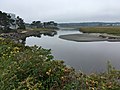
 Ogunquit River in Wells | |
| Location | |
| Country | United States |
| Physical characteristics | |
| Source | |
| • location | Maine |
The Ogunquit River is a 9.8-mile-long (15.8 km)[1] tidal river in southern Maine. It flows to the Atlantic Ocean at the town of Ogunquit.
Images[]

High tide

Mid tide

Low tide


See also[]
- List of rivers of Maine
References[]
- ^ U.S. Geological Survey. National Hydrography Dataset high-resolution flowline data. The National Map Archived 2012-04-05 at WebCite, accessed June 30, 2011
- U.S. Geological Survey Geographic Names Information System: Ogunquit River
- Maine Streamflow Data from the USGS
- Maine Watershed Data From Environmental Protection Agency
Coordinates:  43°15′1.2″N 70°35′43.3″W / 43.250333°N 70.595361°W / 43.250333; -70.595361
Gulf of Maine estuaries | |||||
|---|---|---|---|---|---|
| Maine |
| ||||
| Massachusetts |
| ||||
| New Brunswick |
| ||||
| New Hampshire |
| ||||
| Nova Scotia |
| ||||
This article related to a river in Maine is a stub. You can help Wikipedia by . |
- v
- t
Retrieved from ""
Categories:
- Rivers of York County, Maine
- Ogunquit, Maine
- Rivers of Maine
- Maine river stubs
Hidden categories:
- Webarchive template webcite links
- Coordinates on Wikidata
- AC with 0 elements
- All stub articles