Old Jaffa


Old Jaffa (Hebrew: יפו העתיקה – Ancient Yafo; Arabic: يافا العتيقه – Ancient Jaffa or يافا القديمة – Old Jaffa) is a neighborhood of Tel Aviv-Yafo, Israel and the oldest part of Jaffa. A neighborhood with art galleries, restaurants, theaters, museums, and nightclubs, it is one of Tel Aviv's main tourist attractions.
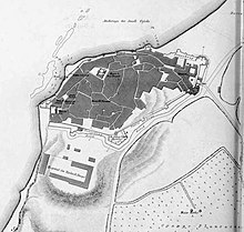
Jaffa is the southwest district of the Tel Aviv–Jaffa municipality.[1] Old Jaffa is located in the northwest of Jaffa, on a hill along the Mediterranean Sea. Geologically, the hill of Old Jaffa is the continental north end of a kurkar ridge, historically further protected through fortifications and heightened by debris.
History[]
Ottoman Empire[]
The Old City was damaged by the Napoleonic wars and an earthquake in 1837.[2] When the wall of Jaffa was dismantled between 1878 and 1888 to allow expansion, both the city and the centres of government shifted eastwards, though the Old City remained the cultural centre of the city.[3][4][5]
British Mandate[]
During the Great Revolt in 1936–1939, the connection between Tel Aviv and the Jaffa port was partially severed by disruption in the Old City.[6] This had two primary effects: the British retaliated using massive gelignite charges to destroy at least 220 buildings, which left over 6000 Arabs homeless,[6] and encouraged the building of a small Jewish port on the Yarkon estuary to the north of Tel Aviv to reduce reliance on Arab Jaffa.
Israel[]
Disputes about the merging of Tel Aviv and Jaffa, with the former wanting only to add the Jewish neighborhoods in the north of Jaffa and the latter wanting a total merge led to a gradual unification.[7] The Old City was partly added on 18 May 1949 as part of the first Arab-controlled land to fall under Jewish control.[7] The remainder of the Old City would be added in 24 April 1950 when the complete unification occurred.[7]
Old Jaffa has increasingly gentrified with the residential population dropping dramatically and an increasing number of art galleries, restaurants, souvenir shops as well as various ongoing archaeological digs.[8][2] There is a particular interest on the cultural melange by the relatively rare, in Israel, triple mix of Muslims, Jews and Christians.[8]
Boundaries[]
Current boundaries of the "Old Jaffa and Jaffa Port" neighborhood, as defined by the Municipality of Tel Aviv-Yafo (clockwise):
- North: north and east of Jaffa Beach, Retzif HaAliya HaShniya
- East: northbound lanes of David Raziel (putting the Jaffa Clock Tower in Old Jaffa), Yefet Street
- South: Yehuda HaYamit, Namal Yafo Street, the southern wall of the Jaffa Port parking lot
- West: the Mediterranean Sea shore
Attractions[]
- Subregions: Jaffa Port in the west and Yefet Street on its eastern border
- Museums, galleries and studios: Farkash Gallery, Uri Geller Museum, Ilana Goor Museum, watchmaker Itay Noy[9]
- Places of worship: Al-Bahr Mosque, Libyan Synagogue, Mahmoudiya Mosque, Saint Nicholas Monastery, St. Peter's Church
- Theaters: The Arab-Hebrew Theater, Hasimta Theater, Nalaga'at
- Towers: Jaffa Clock Tower, Jaffa Light
Immediately outside Old Jaffa: Abouelafia Bakery, Abu Hassan Restaurant
References[]
- ^ "Old Jaffa Tel Aviv travel guide". www.inisrael.com. Retrieved 28 May 2018.
- ^ a b Robert Barzelay (24 January 2017). "Exploring Jaffa: Israel's Ancient Port City". Culture Trip. Retrieved 3 August 2018.
- ^ Kedar, B.Z. (1999). The Changing Land: Between the Jordan and the Sea: Aerial Photographs from 1917 to the Present. Wayne State University Press. p. 96. ISBN 978-0-8143-2915-3. Retrieved 4 August 2018.
- ^ Pinsker, S.M. (2018). A Rich Brew: How Cafés Created Modern Jewish Culture. NYU Press. p. 249. ISBN 978-1-4798-2789-3. Retrieved 4 August 2018.
- ^ LeVine, M. (2005). Overthrowing Geography: Jaffa, Tel Aviv, and the Struggle for Palestine, 1880–1948. University of California Press. p. 56. ISBN 978-0-520-24371-2. Retrieved 4 August 2018.
- ^ a b Hughes, M. (2009) The Banality of Brutality: British Armed Forces and the Repression of the Arab Revolt in Palestine, 1936–39, English Historical Review Vol. CXXIV No. 507, pp. 314–354.
- ^ a b c Arnon Golan (1995), The demarcation of Tel Aviv-Jaffa's municipal boundaries, Planning Perspectives, vol. 10, pp. 383–398.
- ^ a b Rebecca Amir (13 May 2018). "The art awakening transforming Jaffa". Israel21C. Retrieved 3 August 2018.
- ^ Abrams, Melanie (4 December 2017). "From light sculptures to silk-printing: Showcasing Israel's top artisans". Jewish Chronicle. Retrieved 22 May 2019.
Coordinates: 32°3′16.13″N 34°45′10.94″E / 32.0544806°N 34.7530389°E

| Northwest |  | |
|---|---|---|
| Northeast | ||
| Central | ||
| Jaffa (Southwest) | ||
| South | ||
| Southeast | ||
- Old Jaffa
- Neighborhoods of Tel Aviv
- 4th-century BC establishments
- Ancient cities of the Middle East
- Jaffa