Olonkinbyen
This article may be expanded with text translated from the corresponding article in Norwegian. (May 2021) Click [show] for important translation instructions.
|
Olonkinbyen | |
|---|---|
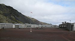
 Olonkinbyen on Jan Mayen island | |
| Etymology: Olonkin City | |
 Olonkinbyen Location of Olonkinbyen in Europe | |
| Coordinates: 70°55′19″N 8°42′54″W / 70.92194°N 8.71500°W | |
| Country | |
| ISO | Svalbard and Jan Mayen |
| Island | Jan Mayen |
| Established | 1962 |
| Population | |
| • Total | c. 18 |
| Time zone | UTC+01:00 (CET) |
| • Summer (DST) | UTC+02:00 (CEST) |
| Website | jan-mayen |

Olonkinbyen[needs IPA] (literally The Olonkin Town) is the only settlement on the Norwegian island of Jan Mayen (aside from isolated cottage huts such as Puppebu[1]). It was named after Russian-Norwegian explorer Gennady Olonkin.[2]
The only inhabitants on the island are the 18 personnel, 14 working for the Norwegian Armed Forces and 4 for the Norwegian Meteorological Institute. Olonkinbyen houses the staff that operate the meteorological observation station, Loran-C station, Jan Mayensfield air field and other infrastructure. The meteorological observation service staff are responsible for the radiosonde releases and synoptic weather observations. The crew of the meteorological station is engaged for six months at a time.[3][4]
Supplies are delivered eight times a year by aircraft. Fuel and heavy goods are transported by boat during the summer. The settlement generates its own electrical power via three generators.[5][6]
In January 2021, two employees of the Armed Forces died in an avalanche.[7]
Climate[]
Olonkinbyen has a tundra climate (Köppen classified as ET), the warmest month is August and the coldest month is March.
| Climate data for Olonkinbyen | |||||||||||||
|---|---|---|---|---|---|---|---|---|---|---|---|---|---|
| Month | Jan | Feb | Mar | Apr | May | Jun | Jul | Aug | Sep | Oct | Nov | Dec | Year |
| Average high °C (°F) | −5 (23) |
−5 (23) |
−5 (23) |
−3 (27) |
0 (32) |
3 (37) |
5 (41) |
5 (41) |
3 (37) |
1 (34) |
−2 (28) |
−4 (25) |
−1 (31) |
| Average low °C (°F) | −10 (14) |
−11 (12) |
−11 (12) |
−9 (16) |
−5 (23) |
−2 (28) |
0 (32) |
1 (34) |
−1 (30) |
−4 (25) |
−7 (19) |
−9 (16) |
−6 (22) |
| Average precipitation cm (inches) | 7.6 (3) |
5.1 (2) |
7.6 (3) |
5.1 (2) |
5.1 (2) |
5.1 (2) |
5.1 (2) |
7.6 (3) |
7.6 (3) |
10 (4) |
7.6 (3) |
7.6 (3) |
81.1 (32) |
| Source: [8] | |||||||||||||
References[]
- ^ http://jan.mayen.no/hytter-pa-jan-mayen/ (In Norwegian)
- ^ "Gennadij Olonkin". polarhistorie.no. Retrieved October 1, 2016.
- ^ "Loran Station Jan Mayen". loran-history.info. Retrieved October 1, 2016.
- ^ "Jan Mayen - Airfield "Jan Mayensfield"". Jan Mayensfield. Retrieved October 1, 2016.
- ^ Images and Information on Olonkin City Archived 2006-05-22 at the Wayback Machine
- ^ "Oppgavene på Jan Mayen". Meteorologisk institutt. Retrieved October 1, 2016.
- ^ https://www.nrk.no/norge/to-ansatte-i-forsvaret-omkom-i-snoskred-pa-jan-mayen-1.15352761 (In Norwegian)
- ^ World Climate Guide
External links[]
Coordinates: 70°55′19″N 8°42′54″W / 70.922°N 8.715°W
- Geography of Jan Mayen
- Populated places of Arctic Norway
- Jan Mayen geography stubs
