Omala, Greece
Omala
Ομαλά | |
|---|---|
 Omala Location within the regional unit 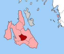 | |
| Coordinates: 38°10′N 20°36′E / 38.167°N 20.600°ECoordinates: 38°10′N 20°36′E / 38.167°N 20.600°E | |
| Country | Greece |
| Administrative region | Ionian Islands |
| Regional unit | Kefalonia |
| Municipality | Argostoli |
| • Municipal unit | 46.699 km2 (18.031 sq mi) |
| Elevation | 400 m (1,300 ft) |
| Population (2011)[1] | |
| • Municipal unit | 840 |
| • Municipal unit density | 18/km2 (47/sq mi) |
| Time zone | UTC+2 (EET) |
| • Summer (DST) | UTC+3 (EEST) |
| Postal code | 281 00 |
| Area code(s) | 26710 |
| Vehicle registration | ΚΕ |

Omala (Greek: Ομαλά) is a former community on the island of Kefalonia, Ionian Islands, Greece. Since the 2019 local government reform it is part of the municipality Argostoli, of which it is a municipal unit.[2] It is located in the south-central part of the island. Its land area is 46.699 km²[3] and its population was 840 inhabitants at the 2011 census. The seat of the community was Valsamata, the only significant town (pop. 763). Its next largest settlements are Epanochori (33), and Michata (25).
References[]
- ^ a b "Απογραφή Πληθυσμού - Κατοικιών 2011. ΜΟΝΙΜΟΣ Πληθυσμός" (in Greek). Hellenic Statistical Authority.
- ^ "Τροποποίηση του άρθρου 1 του ν. 3852/2010" [Amendment of Article 1 of l. 3852/2010] (in Greek). Government Gazette. p. 1164.
- ^ "Population & housing census 2001 (incl. area and average elevation)" (PDF) (in Greek). National Statistical Service of Greece.
This Ionian Islands location article is a stub. You can help Wikipedia by . |
Categories:
- Populated places in Cephalonia
- Ionian Islands geography stubs