Ommeren
Coordinates: 51°57′N 5°30′E / 51.950°N 5.500°E

Ommeren | |
|---|---|
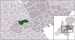 | |
 The town centre (dark green) and the statistical district (light green) of Ommeren in the municipality of Buren. | |
| Country | Netherlands |
| Province | Gelderland |
| Municipality | Buren |
| Population (2006) | ca. 450 |

Ommeren, church
Ommeren is a town in the Dutch province of Gelderland. It is a part of the municipality of Buren, and lies about 9 km northeast of Tiel.
In 2001, the town of Ommeren had 180 inhabitants. The built-up area of the town was 0.047 km², and contained 72 residences.[1] The statistical area "Ommeren", which also can include the peripheral parts of the village, as well as the surrounding countryside, has a population of around 460.[2]
References[]
- ^ Statistics Netherlands (CBS), Bevolkingskernen in Nederland 2001. (Statistics are for the continuous built-up area).
- ^ Statistics Netherlands (CBS), Statline: Kerncijfers wijken en buurten 2003-2005. As of 1 January 2005.
This Gelderland location article is a stub. You can help Wikipedia by . |
Categories:
- Populated places in Gelderland
- Buren
- Gelderland geography stubs