Omuma Local Government
Omuma | |
|---|---|
LGA | |
| Coordinates: 5°05′42″N 7°14′07″E / 5.09492°N 7.23536°ECoordinates: 5°05′42″N 7°14′07″E / 5.09492°N 7.23536°E | |
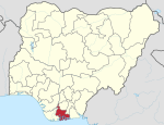
| Country | Nigeria |
| State | Rivers State |
| Date created | October 1, 1996[citation needed] |
| Seat | Eberi |
| Government | |
| • Local Government Chairman | Nwaiwu Chisorom (PDP) |
| • Deputy Local Government Chairman | Ubani Mary (PDP) |
| • Local Government Council | Ward 1: Umesi Obioma (PDP) Ward 2: Promise Reginald (PDP) Ward 3: Ekpendu Prince Eze (PDP) Ward 4: Elike Nwaobia Samuel (PDP) Ward 5: Henry Okechukwu (PDP) Ward 6: Ugochukwu Orji (PDP) Ward 7: Cyril Oluo (PDP) Ward 8: Nwaodu Nnanyibu (PDP) Ward 9: Onyebuchi Onyeche (PDP) Ward 10: Okpoko Lucky (PDP) |
| Area | |
| • Total | 70 sq mi (170 km2) |
| Time zone | UTC+1 (WAT) |

Omuma is a Local Government Area in Rivers State, Nigeria. Its headquarters are in the town of Eberi. Its people are of Igbo extraction.[1]
It has an area of 170 km2 (66 sq mi) and a population of 100,366 at the 2006 census.
The postal code of the area is 512.[2]
[3]==References==
- ^ "State map". Nigerian National Bureau of Statistics. Archived from the original on 2010-05-01. Retrieved 2010-05-19.
- ^ "Post Offices- with map of LGA". NIPOST. Archived from the original on 2012-11-26. Retrieved 2009-10-20.
- ^ https://www.manpower.com.ng/places/lga/737/omuma
| hide Local government areas of Rivers State | ||
|---|---|---|
| LGAs |
|  |
This Rivers State location article is a stub. You can help Wikipedia by . |
Categories:
- Local Government Areas in Rivers State
- 1999 establishments in Nigeria
- 1990s establishments in Rivers State
- Rivers State geography stubs