Ophemert
Ophemert | |
|---|---|
Village | |
 Ophemert Castle | |
 Coat of arms | |
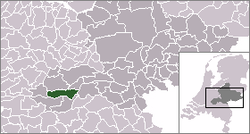 | |
 The village centre (red) and the statistical district (light green) of Ophemert in the former municipality of Neerijnen. | |
| Coordinates: 51°50′43″N 5°23′3″E / 51.84528°N 5.38417°ECoordinates: 51°50′43″N 5°23′3″E / 51.84528°N 5.38417°E | |
| Country | Netherlands |
| Province | Gelderland |
| Municipality | West Betuwe |
| Population (2005) | |
| • Total | 1,630 |
| Time zone | UTC+1 (CET) |
| • Summer (DST) | UTC+2 (CEST) |

Ophemert is a village in the Dutch province of Gelderland. It is a part of the municipality of West Betuwe, and lies about 5 km south of Tiel.
Ophemert was a separate municipality between 1818 and 1978, when it was merged with Neerijnen.[1]
In 2001, the village of Ophemert had 1020 inhabitants. The built-up area of the village was 0.30 km², and contained 389 residences.[2] The statistical area "Ophemert", which also can include the peripheral parts of the village, as well as the surrounding countryside, has a population of around 1670.[3]
Gallery[]
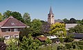
Ophemert, view to the village from the Waalbandijk with reformed church

References[]
- ^ Ad van der Meer and Onno Boonstra, Repertorium van Nederlandse gemeenten, KNAW, 2011.
- ^ Statistics Netherlands (CBS), Bevolkingskernen in Nederland 2001. (Statistics are for the continuous built-up area).
- ^ Statistics Netherlands (CBS), Statline: Kerncijfers wijken en buurten 2003-2005. As of 1 January 2005.
External links[]
| Authority control |
|
|---|
This Gelderland location article is a stub. You can help Wikipedia by . |
Categories:
- Populated places in Gelderland
- Former municipalities of Gelderland
- West Betuwe
- Gelderland geography stubs