Orchard Park Estate
| Orchard Park Estate | |
|---|---|
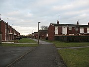
 Caldane, with Milldane flats behind, Danepark (2008) | |
 Orchard Park Estate Location within the East Riding of Yorkshire | |
| OS grid reference | TA068339 |
| Unitary authority | |
| Ceremonial county | |
| Region | |
| Country | England |
| Sovereign state | United Kingdom |
| Post town | HULL |
| Postcode district | HU6 |
| Dialling code | 01482 |
| Police | Humberside |
| Fire | Humberside |
| Ambulance | Yorkshire |
| UK Parliament | |

Orchard Park Estate is an area or housing estate situated on the north-western side of Kingston upon Hull, England.
Geography[]
The Orchard Park Estate is on the northern eastern fringe of the western part Kingston upon Hull adjacent to the city boundary. Cottingham, East Riding of Yorkshire is one mile (1.6 km) directly to the west; the North Hull Estate (Greenwood Avenue) is contiguous adjacent to the south; the eastern boundary is formed by the Beverley and Barmston Drain, beyond which is more housing, and the River Hull (0.5 mi (0.80 km)); to the north is open farmland.[1]
As of 2014 primary schools in the area are Thorpepark Primary;[2] The Parks Primary Academy;[3] and St Anthony's (Roman Catholic).[4]
Population and environment[]
Population at the 2001 and 2011 censuses was around 4,600, with the inhabitants being mainly white families (over 90%), predominately working class. Social housing represented 68% of all housing stock in 2011 (75% in 2001). Unemployment was extremely high in both national and local terms, at 27%.[5] The area has suffered historically from a self re-inforcing negative perceptions of the area, resulting in low house prices and low desirability of properties; the layout of the estate has been characterised as a poorly implemented 'bastardised' version of the Radburn layout,[5] seen as leading to problems around ownership of public spaces, such as parking areas.[5]
History[]
Prior to the estate's development the land was open drained farmland; the northernmost housing development was on the south side of Orchard Park Road (formerly North Carr Lane, dating to at least 1850s). At the west side of the crossing of the road and the Beverley & Barmston drain (Cold Harbour Bridge) was Orchard Park Farm (formerly Cold Harbour farm).[6]
In the 1930s the development of the North Hull Estate brought the urban growth of Hull to the edge of North Carr Lane.[7] A church St Michael and All Angels was built on the north side of North Carr Lane c. 1934; it was replaced by another church c. 1955–7, with the older building reused as a church hall.[8][9][10][11]
1960–2000[]

Construction of the Orchard Park Estate began in 1963. The estate, together with the in East Hull was built as a response to a need for more council housing stock, in part due to slum clearances of older housing stock.[12]
The estate took the form of four 'villages' (Thorpe Park,[map 1] Danepark,[map 2] Courtpark,[map 3] and Shaw Parks[map 4]), each consisting of a housing plan inspired by the Radburn design, each with a central tower block of flats.[12] (Shaw Park lacked tower blocks.[13]) An extension of Hall Road curved through the estate connecting from the Endike Lane (to Cottingham) to Beverley Road (to Beverley); use was made of landscaping with minor hillocks of made ground, mostly along the west and north side of Hall Road.[13]
The estate was built with school facilities as part of the development. These were Thorpe Park Primary & Junior (east end of Hall Road, near Thorpe Park Road);[map 5] Court Park Primary & Junior (Courtway Road);[map 6] Danepark Primary & Junior school (between Feldane & Ealdane, Dane Park Road);[map 7] Shaw Park Primary & Junior (near Dringshaw, Orchard Park Road);[map 8] Sir Henry Cooper High (north-east corner of the estate, Thorpepark Road);[map 9] Sir Leo Schultz High (opposite Isledane, north side of Danepark Road).[map 10] Additionally there were Roman Catholic schools St John Fisher Junior High School;[map 11] and Holy Name Primary,[map 12] adjacent on the west side of Hall Road near the junction with Courtway Road.[13]
Initial plans for an 'integrated neighbourhood centre' made in 1963 were abandoned by the council in 1969; subsequently in 1974 the Orchard Park shopping centre opened.[14][map 13]
Leo Schultz School closed 1986.[15] St John Fisher school closed 1988;[16] the school buildings and site were later used by Humberside Police as a training centre.[17]
2000–present[]

In 2001 the area had high levels of unoccupied housing at 26%.[5]
Shaw Park Primary closed in 2001.[18] Danepark Primary closed 2002.[19] In 2002 the Parks Primary school (Courtway Road, Court Park School site) was formed from the merger of two primary schools.[20] The development, named 'Harrison Park', is expected to be compete late 2016.[21]
Two high-rise flats in the Danepark area (Milldane) were demolished in 2002.[map 14][22] Two of three high-rise flats in the Thorpe Park area (Homethorpe) were demolished in 2002 and 2004 (Drake House and Vernon House).[22][23][map 15]
In 2003 the violent murder of Rachel Moran was carried out by Michael Little on the estate.[24][25]
In the mid to late 2000s the council demolished parts of the estate at Feldane, Gildane, Hardane, and Isledane; reducing he housing density by approximately half, with some of the freed space converted to public space.[26][1][27] A large health centre incorporating a pharmacy was constructed in the late 2000s, and opened in 2009.[28][29][map 16]
In 2008, Hull City Council approved a bid for Private Finance Initiative (PFI) funding to redevelop the estate; this was approved by Housing Minister John Healey in July 2009, with an allocation of £156 million.[30] In 2010, the then Liberal controlled Hull City Council approved the demolition of all remaining high-rise tower blocks on the estate;[31] with over 600 new homes planned to be built on the estate.[32][33] The council's plans to demolish and rebuild housing using PFI funding were upset by cuts in government funding.[34] with the government cancelling all housing PFI projects that were at the pipeline stage.[30] Other PFI projects on the estate outside the project continued, including the "Extra Care" (residential care) project at Homethorpe. The demolition of high-rise and mid-sized flats on the estate was not affected.[30]
Following control of the council passing to the Labour party the flat demolition decision for four of the flats was reviewed, with a report in 2012 recommending the demolition of the flats (Gorthorpe,[map 17] Kinthorpe,[map 18] Laxthorpe,[map 19] and Highcourt[map 20]).[31] In mid 2012 the council decided to refurbish two of the flats (Gorthorpe, and Kinthorpe) due to demand for housing, and demolish the others.[35]
Sir Henry Cooper High School was closed in 2012, with most students and teachers transferring to Thomas Ferens Academy[36] (now known as Sirius Academy North). The Parks Primary school closed 2013,[37] re-opening as The Parks Primary Academy in late 2013.[3] Holy Name primary school was renamed St Anthony's Primary in 2013 after the closure of the nearby Holy Name church.[38][39] The structure of Holy Name church was incorporated into a care home facility in the early 2010s.[40][41][42]
The 22 storey Bridgeman House (Homethorpe) was demolished in 2012.[22][43][map 15] The 22 storey Ashthorpe,[map 21] and Milldane tower blocks,[map 14] were demolished in 2013.[44][45]
In 2013 the city council approved funding for improvements to the housing stock – the main activity was to be energy efficiency improvements to the 1,195 low rise houses of the Wimpey no-fines house type; specifically insulative cladding.[46][47]
The Highcourt tower block was scheduled for demolition in 2014,[map 20] having had its tenancy reduced to only four people;[48] the demolition was completed in March 2015.[49][50]
In March 2014 agreement was reached on work to construct a 52 house new build housing development on the site of the Bridgeman house tower block. The main contractor for the £5 million project was Wates Living Space (Wates Group), acting for the developer, .[51][52] An 'Extra Care' facility with 65 residential places as well as community care facilities was to be built adjacent, also by Riverside.[53] In May 2014 the council decided to demolish the Gorthorpe and Kinthorpe flats which had previously been spared demolition and were planned to be refurbished.[54] In 2014 demolition work for construction of a new shopping centre for the estate began; the development was delayed several years to the difficulty of finding an 'anchor' shopholder for the development, and due to funding difficulties.[55][56][57] Demolition of the Kinthorpe and Laxthorpe flats began September 2014 by mechanical demolition.[58] Demolition of the Gorthorpe flats was delayed due to previous contractual arrangements to provide a site for mobile phone masts.[59] In mid 2016 a new location for the phone masts was found (St Michael and All Angel Church) allowing demolition of the tower block.[60]
As significant redevelopment was taking place in the 2010s the city council investigated the viability of installing district heating into properties in the area – a report by Ramboll published 2014 concluded such as scheme (costing £29.6 million) would not be commercially viable, with a low rate of return of 2.7%.[61]
In 2015 planning permission was granted for 178 new homes in the Danepark area, on a site including the former Milldane tower block.[62] (Construction began late 2016.[63]) In 2016 was awarded a multi-million contract to improve energy efficiency of Hull City Council's housing stock, with measures including the installation of external insulation – 1,668 houses in Orchard Park were to be treated, with work scheduled to start March 2016.[64][65] The 'Wimpey no-fines' houses in the Thorpes, Danes and Courts were to receive cladding.[66][27]
In 2016 the site of the former Henry Cooper school was re-purposed as a 'community park' with some of the former school's sports courts being re-used. The site was renamed "Sir Henry Cooper Park".[67]

Bondane, Danepark (2012)
Clanthorpe, Thorpepark (2011)

Earlescourt, Court Park (2013)

Cladshaw, Shaw Park (2012)
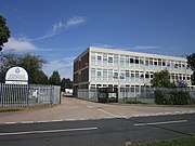
Police college, formerly St John Fisher (RC) school (2013)

Burnt out remains of Dane Park Junior (2008)


See also[]
- List of areas in Kingston upon Hull
- List of large council estates in the UK
References[]
- ^ a b Ordnance Survey 1:25000 2006
- ^ "Thorpepark Primary School (URN): 117808", www.ofsted.gov.uk, retrieved 9 September 2014
- ^ a b "Establishment: The Parks Primary Academy", www.education.gov.uk, General, archived from the original on 10 September 2014, retrieved 9 September 2014
- ^ "St Anthony's Catholic Primary School (URN): 118047", www.ofsted.gov.uk, retrieved 9 September 2014
- ^ a b c d Crookston, Martin (2014), Garden Suburbs of Tomorrow?: A New Future for the Cottage Estates, pp. 77–83
- ^ Ordnance Survey 1:15060 1855, 1911, 1938, 1956
- ^ Ordnance Survey Sheet 226NW 1926.1938
- ^ Neave & Neave 2010, p. 31.
- ^ Ordnance Survey 1:15060 1938, 1956
- ^ Allison 1969, THE PARISH CHURCHES : Modern parishes formed from the Parish of Cottingham .
- ^ Pevsner, Nikolaus; Neave, David (1995). Yorkshire: York and the East Riding. The Buildings of England (2nd ed.). p. 513.
- ^ a b Neave & Neave 2010, p. 33.
- ^ a b c Ordnance Survey 1:2500 1964-7/1969-70
- ^ THE ORCHARD PARK SHOPPING CENTRE (PDF), Orchard Park Environmental Redevelopment Association (OPERA), July 1998, pp. 1–2, retrieved 9 September 2014
- ^ "HULL SIR LEO SCHULTZ HIGH SCHOOL RECORDS", National Archives, retrieved 9 September 2014
- ^ Hull St John Fisher Junior High School, The National Archives, retrieved 13 February 2016
- ^ Property History Help with this page (opens in a new window) 200001247661 – St John Fisher School Courtland Road Kingston Upon Hull HU6 8BE (planning information), Hull City Council, retrieved 13 February 2016
- ^ "Shaw Park Primary School", www.education.gov.uk, archived from the original on 10 September 2014, retrieved 9 September 2014
- ^ "Dane Park Primary School", www.education.gov.uk, archived from the original on 10 September 2014, retrieved 9 September 2014
- ^ "The Parks Primary School (closed) (URN): 133597", www.ofsted.gov.uk, School inspection report 5 Jul 2004, archived from the original on 10 September 2014, retrieved 9 September 2014
- ^ Extra Care Update (PDF), Hull City Council / Riverside / Wates, January 2016, retrieved 12 February 2016
- ^ a b c "Demolition Homethorpe multi-storey flats Orchard Park, Hull", urbanrim.org.uk, retrieved 9 September 2014
- ^ "Only two of original high-rise blocks will remain", Hull Daily Mail, 24 July 2012, archived from the original on 10 September 2014, retrieved 9 September 2014
- ^ Wainwright, Martin (31 October 2003), "Body in cupboard killer jailed for life", The Guardian, retrieved 9 September 2014
- ^ "Rachel's killer jailed for life", BBC News, 30 October 2003, retrieved 9 September 2014
- ^ 03/01180/COU – 1) Change of use of land to public open space following demolition of existing houses. 2) Change of use of amenity land to private garden. 3) Erection of fences and bollards to a maximum height of 1.5m; 4'10. (Amended Proposal). (planning application), Hull City Council, retrieved 12 February 2016
- ^ a b Orchard Park Investment Plan (PDF), Hull City Council / Riverside, June 2015, retrieved 12 February 2016
- ^ 07/01827/FULL – Erection of three storey building to provide accommodation for health centre including G.P. practice, Customer Service Centre, Pharmacy, ancillary office accommodation. Provision of car parking facilities and hard and soft landscaping. (planning application), Hull City Council, 19 December 2007, retrieved 12 February 2016
- ^ "£17m North Hull health centre opens", Hull Daily Mail, 8 December 2009, retrieved 12 February 2016[permanent dead link]
- ^ a b c Williams, Brian (February 2011), "Orchard Park PFI: cancelled housing renewal project", urbanrim.org.uk, retrieved 1 June 2011
- ^ a b "Report backs demolition plan for high-rise flats", Hull Daily Mail, 15 June 2012, archived from the original on 10 September 2014, retrieved 9 September 2014
- ^ "Plans for 680 new homes in Hull considered", BBC News Humberside, 2 October 2010, retrieved 9 September 2014
- ^ "Plans for 670 new homes in Hull approved by council", BBC News Humberside, 25 October 2010, retrieved 9 September 2014
- ^ "Spending cuts hit £150m Hull estate revamp", BBC News Humberside, 22 November 2010, retrieved 9 September 2014
- ^ "'Two up, two down' vote saves Orchard Park tower blocks, but Hull city council will demolish others", Hull Daily Mail, 26 June 2012, archived from the original on 10 September 2014, retrieved 9 September 2014
- ^ "Sir Henry Cooper School (closed) (URN): 118105", www.ofsted.gov.uk, Section 8 inspection report 29 May 2012, retrieved 9 September 2014
- ^ "The Parks Primary School (closed) (URN): 133597", www.ofsted.gov.uk, archived from the original on 10 September 2014, retrieved 9 September 2014
- ^ "St Anthony's Primary School", st-anthonys.hull.sch.uk, retrieved 9 September 2014
- ^ "St Anthony's Catholic Primary School", www.ofsted.gov.uk, 24–25 June 2014, retrieved 9 September 2014
- ^ (11/01175/FULL) 1. Internal alterations including reduction of bedrooms to 64 (originally 72 beds). 2. Erection of single storey extension to side (north) (including raising of land by 645mm) (max 6.5m long x max 5.2m wide x max 3.7m high; 21'4" x 17' x 12'1"). 3. Installation of 1 window and 1 double door to day space on east (rear) elevation. (Revised plans). (planning application), Hull City Council, 15 December 2011, retrieved 15 October 2016
- ^ "Church targeted by vandals could be developed", Hull Daily Mail, 2 June 2010, retrieved 15 October 2016[permanent dead link]
- ^ Wright, Emma (4 March 2014), "Owner fined after Legionella found at Holy Name Care Home in Hull", Hull Daily Mail, archived from the original on 14 March 2014, retrieved 15 October 2016
- ^ "Demolition of Orchard Park tower block Bridgeman House to take place on Sunday", Hull Daily Mail, 27 July 2012, archived from the original on 10 September 2014, retrieved 9 September 2014
- ^ "New builds 'will help push estate forward'", Hull Daily Mail, 15 January 2013, archived from the original on 10 September 2014, retrieved 9 September 2014
- ^ "DemHULLition job: Mixed emotions as Orchard Park flats torn down", Hull Daily Mail, 12 August 2013, archived from the original on 29 June 2015, retrieved 9 September 2014
- ^ "Orchard park", Hull City Council, retrieved 9 September 2014
- ^ Orchard Park Investment Plan (PDF), Hull City Council / Riverside, February 2013, retrieved 9 September 2014[permanent dead link]
- ^ "Orchard Park's Highcourt tower block to be demolished in autumn", Hull Daily Mail, 25 January 2014, archived from the original on 11 September 2014, retrieved 9 September 2014
- ^ Williams, Mark (8 March 2015), "Going, going, gone: Video of Hull's tallest block of flats, Highcourt, demolished in seconds", Hull Daily Mail, archived from the original on 29 June 2015, retrieved 8 March 2015
- ^ "Highcourt tower block demolished in Hull", BBC News Humberside, 8 March 2015, retrieved 10 February 2016
- ^ Shoesmith, Kevin (24 March 2014), "Works starts in Orchard Park on £5m affordable housing to replace tower block", Hull Daily Mail, archived from the original on 10 September 2014, retrieved 9 September 2014
- ^ 13/00480/FULL – Erection of 52 dwellings (29 two-bedroomed houses, 7 three-bedroomed houses, and 16 flats) with associated parking, landscaping, and highway works. (planning application), Hull City Council, 8 May 2013, retrieved 12 February 2016
- ^ 14/00830/FULL – Erection of 65 extra care apartments with associated communal accommodation, car parking and landscaping (planning application), Hull City Council, 25 June 2014, retrieved 12 February 2016
- ^ Young, Angus (2 May 2014), "Orchard Park's Gorthorpe and Kinthorpe tower blocks to be demolished after Hull City Council U-turn", Hull Daily Mail, archived from the original on 10 September 2014, retrieved 9 September 2014
- ^ 13/01296/FULL – Erection of replacement shopping centre for retail, financial and professional services, restaurant, and hot food take away uses (classes A1, A2, A3 & A5 uses) with associated public square, landscaped areas, parking, servicing areas and vehicle accesses to Hall Road, Ellerburn Avenue and Orchard Park Road. (Application to extend the time limit for implementation). (planning application), Hull City Council, 13 December 2013, retrieved 12 February 2016
- ^ "Shopping centre for Hull's Orchard Park 'built by October'", Hull Daily Mail, 7 July 2012, archived from the original on 10 September 2014, retrieved 9 September 2014
- ^ Shoesmith, Kevin (13 July 2013), "Work starts on new Hull shopping centre", Hull Daily Mail, archived from the original on 10 September 2014, retrieved 9 September 2014
- ^ Shoesmith, Kevin (23 September 2014), "Hull's Orchard Park tower blocks 'mechanically dismantled' floor by floor", Hull Daily Mail, archived from the original on 2 December 2014, retrieved 23 September 2014
- ^ Shoesmith, Kevin (12 August 2015), "North Hull phone masts 'to move to Sir Henry Cooper school site'", Hull Daily Mail, archived from the original on 17 August 2015, retrieved 12 August 2015
- ^ Shoesmith, Kevin (26 August 2016), "Demolition of Gorthorpe flats – last Orchard Park tower block – to begin", Hull Daily Mail, retrieved 15 October 2016[permanent dead link]
- ^ Young, Angus (6 December 2014), "Plan to heat Hull's Orchard Park estate gets cold shoulder", Hull Daily Mail, retrieved 12 February 2016[permanent dead link]
- ^ 15/00788/FULL – Erection of 178 dwellings with associated access, parking, landscaping and play space following engineering works to re-profile site. (planning application), Hull City Council, 26 June 2015, retrieved 12 February 2016
- ^ Shoesmith, Kevin (15 October 2016), "Work starts to build 178 homes in Orchard Park", Hull Daily Mail, archived from the original on 17 October 2016, retrieved 15 October 2016
- ^ Blackman, David (10 December 2014), "Willmott Dixon lands £60m Hull Green Deal package", www.building.co.uk, retrieved 12 February 2016
- ^ "Willmott Dixon to improve thousands of homes in Hull", www.willmottdixon.co.uk, 27 December 2016, retrieved 12 February 2016
- ^ "Housing strategy and renewal – Orchard Park", www.hullcc.gov.uk, Housing Improvements, retrieved 12 February 2016
- ^ Shoesmith, Kevin (14 August 2016), "New community park for former Sir Henry Cooper School site in Hull", Hull Daily Mail, retrieved 14 August 2016[permanent dead link]
Locations[]
- ^ 53°47′24″N 0°22′26″W / 53.79008°N 0.37389°W, Thorpe Park (approximate centre)
- ^ 53°47′21″N 0°23′14″W / 53.78914°N 0.38735°W, Danepark (approximate centre)
- ^ 53°47′03″N 0°23′08″W / 53.78418°N 0.38559°W, Court Park (approximate centre)
- ^ 53°47′17″N 0°22′58″W / 53.78798°N 0.38289°W, Shaw Park (approximate centre)
- ^ 53°47′16″N 0°22′19″W / 53.78772°N 0.37182°W, Thorpe Park Primary
- ^ 53°47′04″N 0°23′15″W / 53.78451°N 0.38761°W, Court Park Primary, now The Parks Primary
- ^ 53°47′25″N 0°23′27″W / 53.79017°N 0.39091°W, Dane Park Primary (site of)
- ^ 53°47′19″N 0°22′48″W / 53.78863°N 0.38005°W, Shaw Park Primary (site of)
- ^ 53°47′35″N 0°22′24″W / 53.79292°N 0.37337°W, Sir Henry Cooper High (site of)
- ^ 53°47′32″N 0°23′05″W / 53.79235°N 0.38468°W, Sir Leo Schultz High (site of)
- ^ 53°47′01″N 0°23′22″W / 53.78349°N 0.38956°W, St John Fisher High, now Police college
- ^ 53°47′04″N 0°23′21″W / 53.78445°N 0.38921°W, Holy Name Primary
- ^ 53°47′18″N 0°22′36″W / 53.78832°N 0.37654°W, Orchard Park shopping centre
- ^ a b 53°47′17″N 0°23′14″W / 53.78815°N 0.38731°W, Milldane flats (3 towers, site of)
- ^ a b 53°47′20″N 0°22′26″W / 53.78881°N 0.37400°W, Homethorpe flats (3 towers, site of)
- ^ 53°47′16″N 0°22′27″W / 53.787855°N 0.374229°W, Orchard Centre (health centre)
- ^ 53°47′25″N 0°22′30″W / 53.79020°N 0.37506°W, Gorthorpe flats (site of)
- ^ 53°47′21″N 0°22′20″W / 53.78913°N 0.37213°W, Kinthorpe flats (site of)
- ^ 53°47′18″N 0°22′19″W / 53.78840°N 0.37194°W, Laxthorpe flats (site of)
- ^ a b 53°47′01″N 0°23′11″W / 53.78359°N 0.38626°W, Highcourt flats (site of)
- ^ 53°47′22″N 0°22′46″W / 53.78958°N 0.37953°W, Ashthorpe flats (site of)
Sources[]
- Allison, K.J., ed. (1969). The City of Kingston upon Hull. Victoria County Histories. A History of the County of York East Riding. Vol. 1.
- Neave, David; Neave, Susan (2010). Hull. Pevsner Architectural Guides.
External links[]
| Wikimedia Commons has media related to Orchard Park Estate, Kingston upon Hull. |
- Orchard Park Photography Study (PDF), 2006, ISBN 0-9525791-2-X
- Sir Henry Cooper School, archived from the original on 5 May 2011
| Areas | |
|---|---|
| History | |
| Governance | |
| Economy |
|
| Transport | |
| Health and Education | |
| Religion |
|
| Culture and Sport |
|
| Other topics |
|
- Wards and districts of Kingston upon Hull
- Housing estates in Kingston upon Hull
- Radburn design housing estates
- Geographic histories of Kingston upon Hull