Oruro Department
Department of Oruro | |
|---|---|
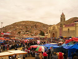 Santuario de la Virgen del Socavón, Carnaval de Oruro, 2007 | |
 Flag  Coat of arms | |
 Location within Bolivia | |
| Country | |
| Capital | Oruro |
| Provinces | 16 |
| Government | |
| • Governor | Edson Oczachoque (MAS-IPSP) |
| Area | |
| • Total | 53,588 km2 (20,690 sq mi) |
| Population (2012 census) | |
| • Total | 494,178 |
| • Density | 9.2/km2 (24/sq mi) |
| Time zone | UTC-4 (BOT) |
| HDI (2017) | 0.700[1] high · 5th |
| Languages | Spanish, Quechua, Aymara |
| Website | www |
Oruro (Spanish pronunciation: [oˈɾuɾo]; Quechua: Uru Uru; Aymara: Ururu) is a department in Bolivia, with an area of 53,588 km2 (20,690 sq mi). Its capital is the city of Oruro. According to the 2012 census, the Oruro department had a population of 494,178.
Provinces of Oruro[]
The department is divided into 16 provinces which are further subdivided into municipalities and cantons.
| Province | Map # | Area (km2) | Population (2012 census) |
Capital | 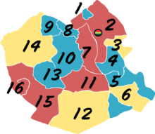 |
|---|---|---|---|---|---|
| Carangas | 10 | 5,472 | 11,041 | Corque | |
| Cercado | 2 | 5,766 | 309,277 | Oruro | |
| Eduardo Avaroa | 5 | 4,015 | 33,248 | Challapata | |
| Ladislao Cabrera | 12 | 8,818 | 14,678 | Salinas de Garci Mendoza | |
| Litoral | 13 | 2,894 | 10,409 | Huachacalla | |
| Nor Carangas | 8 | 870 | 5,502 | Huayllamarca | |
| Pantaleón Dalence | 3 | 1,210 | 29,497 | Huanuni | |
| Poopó | 4 | 3,061 | 16,775 | Poopó | |
| Puerto de Mejillones | 16 | 785 | 2,076 | La Rivera | |
| Sabaya | 15 | 5,885 | 10,924 | Sabaya | |
| Sajama | 14 | 5,790 | 9,390 | Curahuara de Carangas | |
| San Pedro de Totora | 9 | 1,487 | 5,531 | Totora | |
| Saucarí | 7 | 1,671 | 10,149 | Toledo | |
| Sebastian Pagador | 6 | 1,972 | 13,153 | Santiago de Huari | |
| Sud Carangas | 11 | 3,536 | 7,231 | Santiago de Andamarca | |
| Tomás Barrón | 1 | 356 | 5,267 | Eucaliptus |
Note: Eduardo Abaroa Province (#5) is both north of and south of Sebastián Pagador Province (#6).
Government[]
The chief executive officer of Bolivia departments (since May 2010) is the governor; until then, the office was called the prefect, and until 2006 the prefect was appointed by the President of Bolivia. The current governor, Santos Tito of the Movement for Socialism – Political Instrument for the Sovereignty of the Peoples, was elected on 4 April 2010.
The chief legislative body of the department is the Departmental Legislative Assembly, a body also first elected on 4 April 2010. It consists of 33 members: 16 elected by each of the department's provinces; 16 elected based on proportional representation; and minority indigenous representative selected by the .
Languages[]
The languages spoken in the department are mainly Spanish, Quechua and Aymara. The following table shows the number of those belonging to the recognized group of speakers.[2]
| Language | Department | Bolivia |
|---|---|---|
| Quechua | 134,289 | 2,281,198 |
| Aymara | 127,086 | 1,525,321 |
| Guaraní | 383 | 62,575 |
| Another native | 1,943 | 49,432 |
| Spanish | 342,332 | 6,821,626 |
| Foreign | 6,878 | 250,754 |
| Only native | 30,745 | 960,491 |
| Native and Spanish | 188,963 | 2,739,407 |
| Spanish and foreign | 153,439 | 4,115,751 |
Notable people[]
- Evo Morales, who was the Bolivian president from 2006 to 2019, was born in the village of Isallawi near Orinoca.
Places of interest[]
- Sajama National Park
- Parinacota Volcano
- Sajama Lines
- Poopó Lake
- Lake Uru Uru
- Paria, first Spanish settlement in Bolivia, former Inca city.
See also[]
References[]
- ^ "Sub-national HDI - Area Database - Global Data Lab". hdi.globaldatalab.org. Retrieved 13 September 2018.
- ^ obd.descentralizacion.gov.bo Archived 18 February 2009 at the Wayback Machine (Spanish)
External links[]
- Oruro Travel Guide
- Weather in Oruro
- Carnaval 2009 folklore
- Technical University of Oruro
- Oruro News
- Feria Exposición Archived 20 June 2018 at the Wayback Machine
- Chisholm, Hugh, ed. (1911). . Encyclopædia Britannica (11th ed.). Cambridge University Press.
- Full information of Oruro Department
Coordinates: 18°40′S 67°40′W / 18.667°S 67.667°W


| show Departments of Bolivia |
|---|
| show Authority control |
|---|
- Oruro Department
- Departments of Bolivia