Ossetian Military Road
This article relies largely or entirely on a single source. (July 2021) |
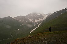
The Ossetian Military Road (Russian: Военно-Осетинская дорога, Georgian: ოსეთის სამხედრო გზა) was constructed between 1854 and 1889, by the Russian Empire in the Caucasus. The road runs through the Rioni and Ardon river valleys and links Kutaisi (Georgia) with Alagir (Russia), crossing the Greater Caucasus crest through the Mamison Pass (Kutaisi-Alpana-Mamison road) at 2,911 metres (9,551 ft). The 270 kilometres (170 mi) long route is seldom used today, having been supplanted by the 1971-1981 construction of the Transcaucasian Highway, which crosses the Caucasus range via the Roki Tunnel. Alternative crossings include the Georgian Military Road, which crosses the Jvari Pass at 2,379 metres (7,805 ft).
References[]
- “The Ossetian Military Road” in: The Columbia Encyclopedia, Sixth Edition, 2001-05: Columbia University Press.
Coordinates: 42°40′58″N 43°43′38″E / 42.6827°N 43.7271°E

This South Ossetia-related article is a stub. You can help Wikipedia by . |
This Georgia location article is a stub. You can help Wikipedia by . |
This Russian road or road transport-related article is a stub. You can help Wikipedia by . |
This article about transport in Georgia is a stub. You can help Wikipedia by . |
- Roads in Russia
- Roads in Georgia (country)
- Transport in North Ossetia–Alania
- Roads in South Ossetia
- Military roads
- South Ossetia stubs
- Georgia (country) geography stubs
- Russia road stubs
- Asia transport stubs
- Georgia (country) stubs
- Europe transport stubs