Otake (Nakanoshima)
| Otake | |
|---|---|
| 御岳 | |
 Inside the crater. (May 2007) | |
| Highest point | |
| Elevation | 979 m (3,212 ft) |
| Prominence | 979 m (3,212 ft) |
| Listing | List of mountains and hills of Japan by height List of volcanoes in Japan |
| Coordinates | 29°51′33″N 129°51′25″E / 29.85917°N 129.85694°ECoordinates: 29°51′33″N 129°51′25″E / 29.85917°N 129.85694°E |
| Naming | |
| English translation | honorable mountain |
| Language of name | Japanese |
| Geography | |
| Location | Nakanoshima, Japan |
| Topo map | Geographical Survey Institute, 25000:1 中之島, 50000:1 中之島 |
| Geology | |
| Age of rock | Late Pleistocene-Holocene |
| Mountain type | stratovolcano |
| Volcanic arc/belt | Ryukyu arc |
| Last eruption | October 1944 |

Otake (御岳, O-take) is a stratovolcano[1] in the Tokara Islands of Japan. It is the largest mountain on Nakanoshima, which is part of the village of Toshima in Kagoshima District of Kagoshima Prefecture. Being the largest mountain on a small island, it is also referred to as Nakanoshima. It is also called "Tokara Fuji" from its shape.
The mountain is an andesitic volcano. The volcano had a minor mud eruption in January 1914. In October 1949 the summit crater produced an ash cloud.[1][2] The rock of the mountain is non-alkali mafic rock produced in the last 18,000 years.[3]
Sulphur mining took place on the southeast flank until 1944. During the rainy season, the summit crater fills with water.[2]
The volcano last erupted in 2007.
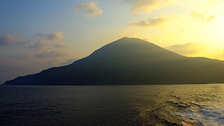
Otake at dawn seen from the sea
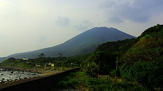
Otake seen from the west coast of Nakanoshima
See also[]
References[]
- ^ Jump up to: a b "NAKANO-SHIMA". Quaternary Volcanoes of Japan. Geographical Survey Institute, AIST. 2006. Archived from the original on 2012-12-19. Retrieved 2009-04-24.
- ^ Jump up to: a b "Nakanoshima". Global Volcanism Program. Smithsonian Institution. Retrieved 2021-06-24.
- ^ "Kyushu". Seamless Digital Geological Map of Japan. Geographical Survey of Japan, AIST. 2006. Retrieved 2009-04-24.
- Mountains of Kagoshima Prefecture
- Volcanoes of Kagoshima Prefecture