Outline of Barbados


The location of Barbados

An enlargeable relief map of Barbados
The following outline is provided as an overview of and introduction to Barbados:
Barbados – sovereign island country in the Lesser Antilles. It is one of the Caribbean's leading tourist destinations and is one of the most developed islands in the region.
General reference[]

An enlargeable basic map of Barbados

A highly detailed map of Barbados
- Pronunciation:
- Barbadian English: /bɑːrˈbeɪdoʊz/
- British English: /bɑːrˈbeɪdɒs/
- American English: /bɑːrˈbeɪdoʊz/ (
 listen)
- Pronunciation:
- Common English country name: Barbados
- Official English country name: Barbados
- Common endonym(s):
- Official endonym(s):
- Adjectival(s): Barbadian
- Demonym(s):
- Etymology: Name of Barbados
- International rankings of Barbados
- International Telecommunications Union callsign prefix: 8P
- ISO country codes: BB, BRB, 052
- ISO region codes: See ISO 3166-2:BB
- Internet country code top-level domain: .bb
Geography of Barbados[]
- Barbados is...
- an island
- a country
- an island country
- a nation state
- a Commonwealth realm
- Coastline: 97 km
- Population of Barbados: 287,711 - 174th most populous country
- Area of Barbados: 431 square kilometres (166 sq mi) - 199th largest country
- Atlas of Barbados
Location of Barbados[]
- Barbados is located within the following regions:
- Northern Hemisphere and Western Hemisphere
- North America (though not on the mainland, just north of South America, off the coast of Venezuela)
- Atlantic Ocean
- North Atlantic
- West Indies
- Southern Caribbean
- Antilles
- Lesser Antilles
- West Indies
- North Atlantic
- Time zone: Atlantic Standard Time
- Northern Hemisphere and Western Hemisphere
- Extreme points of Barbados
- Northernmost point – North Point, Saint Lucy (N 13.334851, W -59.614742)
- Southernmost point – South Point, Christ Church (N 13.045294, W -59.526722)
- Easternmost point – Kitridge Point, Saint Philip (N 13.149207, W -59.420292)
- Westernmost point – Harrisons, Saint Lucy, Saint Lucy (N 13.305756, W -59.651022)
- High: Mount Hillaby 336 m (1,102 ft)
- Low: North Atlantic Ocean 0 m
- Land boundaries: none
Environment of Barbados[]
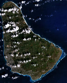
An enlargeable satellite image of Barbados
- Climate of Barbados
- Wildlife of Barbados
- Barbados Wildlife Reserve
- Fauna of Barbados
Natural geographic features of Barbados[]
- Beaches in Barbados
- Islands of Barbados
- Rivers of Barbados
- World Heritage Sites in Barbados: Bridgetown
Regions of Barbados[]
Regions of Barbados
- English place names in Barbados
Ecoregions of Barbados[]
List of ecoregions in Barbados
Administrative divisions of Barbados[]
Administrative divisions of Barbados
- Parishes of Barbados
- Christ Church
- Saint Andrew
- Saint George
- Saint James
- Saint John
- Saint Joseph
- Saint Lucy
- Saint Michael
- Saint Peter
- Saint Philip
- Saint Thomas
Municipalities of Barbados[]
Demography of Barbados[]
Government and politics of Barbados[]
- Form of government: constitutional monarchy and a parliamentary government with strong democratic traditions
- Capital of Barbados: Bridgetown
- Elections in Barbados
- Political parties in Barbados
Branches of government[]
Executive branch of the government of Barbados[]
Government of Barbados
- Head of state: Queen of Barbados, Elizabeth II
- Her Majesty's representative: Governor-General of Barbados
- Head of government: Prime Minister of Barbados
- Cabinet of Barbados
- Ministries and agencies of the Barbados government
Legislative branch of the government of Barbados[]
- Parliament of Barbados (bicameral)
- Upper house: Senate of Barbados
- Lower house: Barbados House of Assembly
Judicial branch of the government of Barbados[]
Court system of Barbados Judiciary of Barbados
- Caribbean Court of Justice
- Supreme Court of Barbados
Foreign relations of Barbados[]
Foreign relations of Barbados
- Diplomatic missions in Barbados
- Diplomatic missions of Barbados
- Relations with specific countries
- Australia–Barbados relations
- Barbados–Brazil relations
- Barbados–Canada relations
- Barbados–China relations
- Barbados–France Maritime Delimitation Agreement
- Barbados–France relations
- Barbados–Germany relations
- Barbados–Grenada relations
- Barbados–Guyana relations
- Barbados–India relations
- Barbados–Japan relations
- Barbados–Nigeria relations
- Barbados–Suriname relations
- Barbados–Trinidad and Tobago relations
- Barbados–United Kingdom relations
- Barbados–United States relations
- Embassy of Barbados in Washington, D.C.
International organization membership[]
Barbados is a member of:[1]
|
|
Law and order in Barbados[]
Law of Barbados
- Constitution of Barbados
- Crime in Barbados
- Human rights in Barbados
- LGBT rights in Barbados
- Law enforcement in Barbados
Military of Barbados[]
Military of Barbados
- Command
- Commander-in-chief
- Barbados Defence Force
- Barbados Coast Guard
- Army of Barbados
- Navy of Barbados
- Military history of Barbados
- Military ranks of Barbados
- Project HARP
Local government in Barbados[]
Local government in Barbados
History of Barbados[]
History of Barbados
- Timeline of Barbadian history
- Current events of Barbados
- Military history of Barbados
Culture of Barbados[]
- Barbados Lottery
- Cuisine of Barbados
- Languages of Barbados
- English in Barbados
- English place names in Barbados
- English in Barbados
- Media in Barbados
- Newspapers in Barbados
- Radio stations in Barbados
- Television in Barbados
- National symbols of Barbados
- Coat of arms of Barbados
- Flag of Barbados
- National anthem of Barbados
- People of Barbados
- Public holidays in Barbados
- Religion in Barbados
- Anglican Church of Barbados
- Hinduism in Barbados
- Islam in Barbados
- Judaism in Barbados
- Scouting and Guiding in Barbados
- World Heritage Sites in Barbados:
Arts and entertainment in Barbados[]
- Beauty pageants in Barbados
- Miss Barbados Universe
- Miss Barbados World
Art in Barbados[]
- Music of Barbados
Sports in Barbados[]
Sports in Barbados
- Cricket in Barbados
- Barbados Cricket Association
- Barbados Cricket Buckle
- Barbados national cricket team
- Cycling in Barbados
- Football in Barbados
- Netball in Barbados
- Rugby in Barbados
- Volleyball in Barbados
- Barbados at international sports competitions
- Barbados at the Commonwealth Games
- Barbados at the Pan American Games
- Barbados at the Paralympics
- Barbados at the Olympics
- Barbados at the 1968 Summer Olympics
- Barbados at the 1972 Summer Olympics
- Barbados at the 1976 Summer Olympics
- Barbados at the 1984 Summer Olympics
- Barbados at the 1988 Summer Olympics
- Barbados at the 1992 Summer Olympics
- Barbados at the 1996 Summer Olympics
- Barbados at the 2000 Summer Olympics
- Barbados at the 2004 Summer Olympics
- Barbados at the 2008 Summer Olympics
- Barbados at the 2012 Summer Olympics
- Other international sports competitions
- Barbados at the 2009 World Championships in Athletics
- Barbados at the 2010 Central American and Caribbean Games
- Barbados at the 2010 Summer Youth Olympics
- Barbados at the 2011 World Aquatics Championships
- Barbados at the 2011 World Championships in Athletics
- Other
- Barbados Davis Cup team
- Barbados FA Cup
- Barbados Fed Cup team
- Barbados First Division
- Barbados Gold Cup
- Barbados National Stadium
- 2010 Barbados Premier Division
- 2011 Barbados Premier Division
- Association football in Barbados
- Barbados Olympic Association
- Barbados Premier Division
- Barbados women's national football team
- Barbados women's national rugby union team
- Barbados women's national volleyball team
- Carlton Cricket Club (Barbados)
- List of football clubs in Barbados
- List of international cricketers from Barbados
- Rugby union in Barbados
- Technico (Barbados football club)
Economy and infrastructure of Barbados[]
Economy of Barbados
- Economic rank, by nominal GDP (2007): 144th (one hundred and forty fourth)
- Banking in Barbados
- Central Bank of Barbados
- Communications in Barbados
- List of postal codes in Barbados
- Internet in Barbados
- Companies of Barbados
- Currency of Barbados: Dollar
- ISO 4217: BBD
- Barbados Stock Exchange
- Tourism in Barbados
- Transport in Barbados
- Air transport in Barbados
- Airlines of Barbados
- Airports in Barbados
- Port of Bridgetown
- Air transport in Barbados
Education in Barbados[]
Health in Barbados[]
See also[]
| English language edition of Wikipedia, the free encyclopedia |
Barbados
- All pages with titles beginning with Barbados
- All pages with titles beginning with Barbadian
- All pages with titles containing Barbados
- All pages with titles containing Barbadian
- Index of Barbados-related articles
- List of Barbados-related topics
- List of international rankings
- Member state of the Commonwealth of Nations
- Member state of the United Nations
- Outline of geography
- Outline of North America
- Monarchy of Barbados
- 1831 Barbados hurricane
- Amateur radio call signs of Barbados
- Bahá'í Faith in Barbados
- Banks Barbados Brewery
- Barbados (band)
- Barbados (composition)
- Barbados (Typically Tropical song)
- Barbados and CARICOM
- Barbados anole
- Barbados Association for Children With Intellectual Challenges
- Barbados Blackbelly sheep
- Barbados bullfinch
- Barbados Civil Aviation Department
- Barbados Defence Force Sports Program
- Barbados Independence Act 1966
- Barbados Joe Walcott
- Barbados leaf-toed gecko
- Barbados Light and Power Company
- Barbados lottery
- Barbados Museum & Historical Society
- Barbados National Archives
- Barbados National Oil Company Limited
- Barbados National Pledge
- Barbados National Trust
- Barbados nationality law
- Barbados passport
- Barbados Police Headquarters
- Barbados Port Incorporated
- Barbados Programme of Action
- Barbados raccoon
- Barbados racer
- Barbados rail
- Barbados Red Cross Society
- Barbados Regiment
- Barbados Sky
- Barbados Slave Code
- Barbados Stock Exchange
- Barbados threadsnake
- Barbados Transport Board
- Barbados Triple Crown of Thoroughbred Racing
- Barbados v. Trinidad and Tobago
- Barbados Water Authority
- Barbados Wildlife Reserve
- Barbados Workers' Union
- Battle off Barbados
- Bishop of Barbados
- CBC Radio (Barbados)
- CBC TV 8 (Barbados)
- Codrington School (Barbados)
- Congress of Trade Unions and Staff Associations of Barbados
- David Bentley (Bishop of Barbados)
- DGM Barbados Open
- Douglas Lynch (Barbados)
- Foundation School (Barbados)
- Freemasonry in Barbados
- George Washington House (Barbados)
- Governor-General of Barbados
- Harrison College (Barbados)
- High Commission of Barbados, Ottawa
- Immigration to Barbados
- Index of Barbados-related articles
- Indian River (Barbados)
- Indians in Barbados
- Industrial heritage of Barbados
- Institute of Chartered Accountants of Barbados
- Knight or Dame of St. Andrew (Barbados)
- Landship (Barbados)
- List of Governors of Barbados
- List of High Commissioners of the United Kingdom to Barbados
- List of people on stamps of Barbados
- List of plantations in Barbados
- List of Speakers of the House of Assembly of Barbados
- Long Pond River (Barbados)
- Mártires de Barbados Stadium
- Multi-Choice TV (Barbados)
- Music history of Barbados
- National Library Service of Barbados
- Order of Barbados
- Parkinson Memorial Secondary School (Barbados)
- Pelican Island (Barbados)
- Quality FM (Barbados)
- Queen's College (Barbados)
- Royal Barbados Police Band
- Sheraton Centre (Barbados)
- Sherbrooke (Barbados)
- Shipping Association of Barbados
- Silver Sands (Barbados football club)
- Table of precedence for Barbados
- The Barbados Advocate
- The Daily Nation (Barbados)
- The One 98.1 FM (Barbados)
- The Ursuline Convent (Barbados)
- To Hell or Barbados
- Voice of Barbados
- William Douglas (Barbados)
- Republicanism in Barbados
- List of Prime Ministers of Barbados
- Senate of Barbados
- Members of the Senate of Barbados
- House of Assembly of Barbados
- List of Presidents of the Legislative Council of Barbados
- List of Presidents of the Senate of Barbados
- Supreme Court of Judicature (Barbados)
- United States Ambassador to Barbados
- United States Ambassador to Barbados and the Eastern Caribbean
- Royal Barbados Police Force
- Postage stamps and postal history of Barbados
- Postal codes in Barbados
- Telecommunications in Barbados
- TeleBarbados
- Highways in Barbados
- Vehicle registration plates of Barbados
References[]
- ^ "Barbados". The World Factbook. United States Central Intelligence Agency. July 2, 2009. Retrieved July 23, 2009.
External links[]
Barbadosat Wikipedia's sister projects
 Definitions from Wiktionary
 Media from Wikimedia Commons
 News from Wikinews
 Quotations from Wikiquote
 Texts from Wikisource
 Textbooks from Wikibooks
 Resources from Wikiversity
- Barbados Government - official website
- Barbados Cricket Association
- Barbados Investment and Development Corporation
- Barbados Museum & Historical Society
- Barbados Statistical Service (BSS)
- Barbados Tourism Authority - The Ministry of Tourism
- Central Bank of Barbados website
- Parliament of Barbados official website
- Parliament of Barbados - Some facts about Barbados
| show Outline of the Americas |
|---|

Categories:
- Outlines of countries
- Wikipedia outlines
- Barbados
- Barbados-related lists