Póvoa de Lanhoso
Póvoa de Lanhoso | |
|---|---|
 Flag  Coat of arms | |
 | |
| Coordinates: 41°34′N 8°16′W / 41.567°N 8.267°WCoordinates: 41°34′N 8°16′W / 41.567°N 8.267°W | |
| Country | |
| Region | Norte |
| Intermunic. comm. | Ave |
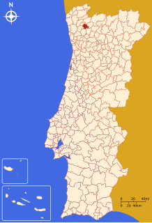
| District | Braga |
| Parishes | 22 |
| Government | |
| • President | Avelino Silva (PSD) |
| Area | |
| • Total | 134.65 km2 (51.99 sq mi) |
| Population (2011) | |
| • Total | 21,886 |
| • Density | 160/km2 (420/sq mi) |
| Time zone | UTC±00:00 (WET) |
| • Summer (DST) | UTC+01:00 (WEST) |
| Website | www |

Póvoa de Lanhoso (Portuguese pronunciation: [ˈpɔvu.ɐ ðɨ lɐˈɲozu] (![]() listen), locally [ˈpɔβwɐ ðɨ lɐˈɲozu]) is a municipality in the district of Braga, Portugal. The population in 2011 was 21,886,[1] in an area of 134.65 km².[2]
listen), locally [ˈpɔβwɐ ðɨ lɐˈɲozu]) is a municipality in the district of Braga, Portugal. The population in 2011 was 21,886,[1] in an area of 134.65 km².[2]
The present Mayor is Avelino Silva,[3] elected by the Social Democratic Party. The municipal holiday is March 19.
Parishes[]
The municipality is subdivided into the following 22 parishes:[4]
- Águas Santas e Moure
- Calvos e Frades
- Campos e Louredo
- Covelas
- Esperança e Brunhais
- Ferreiros
- Fonte Arcada e Oliveira
- Galegos
- Garfe
- Geraz do Minho
- Lanhoso
- Monsul
- Póvoa de Lanhoso
- Rendufinho
- Santo Emilião
- São João de Rei
- Serzedelo
- Sobradelo da Goma
- Taíde
- Travassos
- Verim, Friande e Ajude
- Vilela
References[]
- ^ Instituto Nacional de Estatística
- ^ "Áreas das freguesias, concelhos, distritos e país". Archived from the original on 2018-11-05. Retrieved 2018-11-05.
- ^ https://www.povoadelanhoso.pt/municipio/camara-municipal/executivo-pelouros/
- ^ Diário da República. "Law nr. 11-A/2013, pages 552 100-101" (PDF) (in Portuguese). Retrieved 10 July 2014.
External links[]
| Wikimedia Commons has media related to Póvoa de Lanhoso. |
| show Authority control |
|---|
This Braga District location article is a stub. You can help Wikipedia by . |
Categories:
- Póvoa de Lanhoso
- Braga geography stubs