Pukawa
Pukawa | |
|---|---|
Rural locality | |
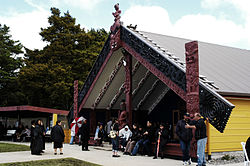 Wharenui, Manunui-a-Ruakapanga Marae | |
 | |
| Coordinates: 38°55.0′S 175°45.3′E / 38.9167°S 175.7550°ECoordinates: 38°55.0′S 175°45.3′E / 38.9167°S 175.7550°E | |
| Country | New Zealand |
| Region | Waikato |
| Territorial authority | Taupo District |
| Ward | Turangi-Tongariro |
| Population (2018) | |
| • Total | 114 |
| Postcode(s) | 3381 |

Pukawa or Pukawa Bay (Māori: Pūkawa) is a bay and a small township on the southern shores of Lake Taupo on New Zealand's North Island. It is off State Highway 41 between Turangi and Taumarunui, in the Taupo District and Waikato region.[1]
It is home of the Ngāti Tūwharetoa hapū of Ngāti Manunui, who established the Pūkawa Marae and Manunui a Ruakapanga meeting house in November 2006.[2][3] The opening ceremony was attended by Tuheitia Paki, the Māori King.[4]
Pōtatau Te Wherowhero was formally selected as king by a conference of chiefs of the Māori tribes held at Pukawa in April 1857 and was crowned during elaborate ceremonies held at his marae in Ngāruawāhia in April 1858.[5]
In 1906 Ngāti Tūwharetoa and the Tongariro Timber Company struck an agreement for the construction of a 40-mile railway line from Kakahi (on the main trunk line) to Pukawa. This line was never completed.[6]
Demographics[]
| Year | Pop. | ±% p.a. |
|---|---|---|
| 2006 | 1,620 | — |
| 2013 | 1,578 | −0.37% |
| 2018 | 1,566 | −0.15% |
| Source: [7] | ||
The statistical area of Lake Taupo Bays covers 1155 square kilometres to the south and west of Lake Taupo. It surrounds but does not include Tūrangi. It had a population of 1,566 at the 2018 New Zealand census, a decrease of 12 people (-0.8%) since the 2013 census, and a decrease of 54 people (-3.3%) since the 2006 census. There were 645 households. There were 810 males and 756 females, giving a sex ratio of 1.07 males per female. The median age was 52.8 years (compared with 37.4 years nationally), with 267 people (17.0%) aged under 15 years, 174 (11.1%) aged 15 to 29, 687 (43.9%) aged 30 to 64, and 438 (28.0%) aged 65 or older.
Ethnicities were 69.2% European/Pākehā, 41.0% Māori, 2.5% Pacific peoples, 2.3% Asian, and 1.3% other ethnicities (totals add to more than 100% since people could identify with multiple ethnicities).
The proportion of people born overseas was 11.9%, compared with 27.1% nationally.
Although some people objected to giving their religion, 48.3% had no religion, 36.4% were Christian and 8.8% had other religions.
Of those at least 15 years old, 219 (16.9%) people had a bachelor or higher degree, and 240 (18.5%) people had no formal qualifications. The median income was $28,300, compared with $31,800 nationally. The employment status of those at least 15 was that 552 (42.5%) people were employed full-time, 189 (14.5%) were part-time, and 48 (3.7%) were unemployed.[7]
Pukawa, including Oreti Village and Omori, is in meshblocks 1026008-110 and 1026503-508, which had a population of 114 in the 2018 census.[8]
Notable people[]
Bessie te Wenerau Grace
References[]
- ^ "Map of Pukawa on Lake Taupo". jcsmaps.co.nz. J C S Maps.
- ^ "Te Kāhui Māngai directory". tkm.govt.nz. Te Puni Kōkiri.
- ^ "Māori Maps". maorimaps.com. Te Potiki National Trust.
- ^ "Thousands Expected At New Pukawa Marae". newswire.co.nz. Archived from the original on 10 March 2007. Retrieved 18 November 2006.
- ^ "Pictures: Māori Monarchs since 1858". nzherald.co.nz. New Zealand Media and Entertainment.
- ^ Cowan, James; R. E. Owen. "Chapter 16: The Maori King". The New Zealand Wars: Volume I (1845–64): A History of the Maori Campaigns and the Pioneering Period. New Zealand Electronic Text Centre. Retrieved 16 October 2006.
- ^ a b "Statistical area 1 dataset for 2018 Census". Statistics New Zealand. March 2020. Lake Taupo Bays (187900). 2018 Census place summary: Lake Taupo Bays
- ^ "Meshblock Electoral Populations 2020 for proposed boundaries data". Statistics New Zealand. April 2020. Meshblocks 1026008-110 and 1026503-508.
- Populated places in Waikato
- Taupo District
- Bays of Waikato
- Populated places on Lake Taupō