Pai District
Pai
ปาย | |
|---|---|
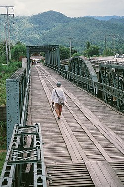 Tha Pai Memorial Bridge in 2009. | |
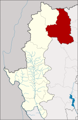 District location in Mae Hong Son Province | |
| Coordinates: 19°21′31″N 98°26′24″E / 19.35861°N 98.44000°ECoordinates: 19°21′31″N 98°26′24″E / 19.35861°N 98.44000°E | |
| Country | Thailand |
| Province | Mae Hong Son |
| Area | |
| • Total | 2,244.7 km2 (866.7 sq mi) |
| Population (2005) | |
| • Total | 29,526 |
| • Density | 13.2/km2 (34/sq mi) |
| Time zone | UTC+7 (ICT) |
| Postal code | 58130 |
| Geocode | 5803 |

Pai District (Thai: ปาย, pronounced [pāːj]) is the northeasternmost district (amphoe) of Mae Hong Son Province, northern Thailand.
Geography[]
The Daen Lao Range dominates the landscape of this district. Neighboring districts are (from west clockwise): Mueang Mae Hong Son, Pang Mapha of Mae Hong Son Province; Shan State of Myanmar; Wiang Haeng, Chiang Dao, Mae Taeng, Samoeng, and Galyani Vadhana of Chiang Mai Province.
The main rivers in the district are the Pai and .
Symbols[]
The district slogan is, "Pai River, worship Luang Pho Un Mueang, spread good kind of garlic, surrounded by lush forests, way of life evenly between hot and cold".
History[]
In the year 1477 during the King Tilokaraj's reign of Lanna Kingdom. He ordered Prince Si Chai to attack Burmese army at Ban Don. During the battle, two of his white elephants fled. He asked the soldiers to find before found that they were swimming in an unnamed river. Therefore he named this river "Pai", which comes from the name of the elephant "Chang Pai".
After winning the war. The King established him as Lord Chai Songkhram and has been in charge of Pai since then.[1]
Administration[]
The district is divided into seven sub-districts (tambons), which are further subdivided into 66 villages (mubans). Pai itself has township (thesaban tambon) status and covers parts of tambon Wiang Tai. There are a further seven tambon administrative organizations (TAO).

| No. | Name | Thai name | Villages | Pop. | |
|---|---|---|---|---|---|
| 1. | Wiang Tai | เวียงใต้ | 8 | 6,493 | |
| 2. | Wiang Nuea | เวียงเหนือ | 10 | 3,727 | |
| 3. | Mae Na Toeng | แม่นาเติง | 14 | 6,417 | |
| 4. | แม่ฮี้ | 6 | 2,835 | ||
| 5. | ทุ่งยาว | 12 | 3,990 | ||
| 6. | เมืองแปง | 9 | 3,198 | ||
| 7. | โป่งสา | 7 | 2,866 |
Sights[]
Pai, at present[when?] it is well known as an important tourist destination of Mae Hong Son. It is therefore very popular with both Thai and foreign tourists especially young people and also being used as a location for filming movies such as Ruk Jung in 2006, Pai in Love and Kat Rattakarn's Ya Kuet Nak-MV in 2009, Timeline in 2014 etc.[1]
- Wat Si Don Chai (Luang Sa Ri Bua Ban), the first temple of Pai, older than 700 years.[1]
- Tha Pai Memorial Bridge[2]
- Wat Nam Hu
- Wat Sai Khao
- Mo Paeng Waterfall
- Pam Bok Waterfall
- The Pai Secret Hot Springs
- Tha Pai Hot Spring
- Yun Lai Viewpoint
- Santichon Village, Chinese Yunan Cultural Village
- Huai Nam Dang National Park (shares with Mae Taeng and Wiang Haeng Districts of Chiang Mai Province)
- Pai River
- Kong Lan or Pai Canyon
- Pai Walking Street
References[]
- ^ a b c jasminta (2015-09-02). "เที่ยวชมวัดศรีดอนชัย ศูนย์รวมใจคนเมืองปาย" [Visiting Wat Si Don Chai, spiritual anchor of Pai people]. Mthai.com. Retrieved 2019-09-08.
- ^ "Tha Pai Memorial Bridge historical landmark in Pai". My Chiang Mai Tour.
| Wikimedia Commons has media related to Pai District. |
External links[]
 Pai travel guide from Wikivoyage
- cdd.go.th Pai History
This Mae Hong Son province location article is a stub. You can help Wikipedia by . |
- Amphoe of Mae Hong Son Province
- Geography of Mae Hong Son province
- Mae Hong Son province geography stubs