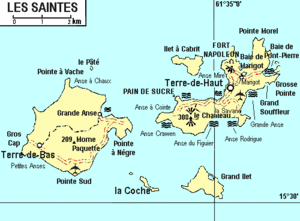
Pain-de-Sucre, les Saintes
Pain-de-Sucre | |
|---|---|
Quartier | |
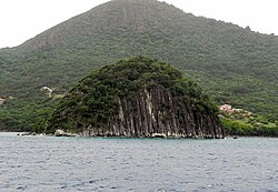 Pain de sucre hill with its village behind | |
 | |
| Coordinates: 15°51′40″N 61°35′54″W / 15.86111°N 61.59833°WCoordinates: 15°51′40″N 61°35′54″W / 15.86111°N 61.59833°W | |
| Country | |
| Overseas department | |
| Canton | les Saintes |
| commune | Terre-de-Haut |

Pain-de-Sucre is a quartier of Terre-de-Haut Island, located in Îles des Saintes archipelago in the Caribbean. It is located in the southwestern part of the island. This is a residential quartier of Terre-de-Haut Island. It is a natural anchorage. The famous Pain de sucre of the archipelago is located on this quartier.
To see[]
- Pain de sucre: This is a famous mountain of les Saintes. It is constituted by an alignment of basalt columns plunging into the blue waters of the bay of les Saintes.[1]
- The beaches called Petite Anse du Pain de sucre and Anse Devant are two small beautiful beaches of white sand and turquoise water.
Notes[]
- ^ "Archived copy". Archived from the original on 2012-03-21. Retrieved 2011-12-18.
{{cite web}}: CS1 maint: archived copy as title (link)
This Guadeloupe location article is a stub. You can help Wikipedia by . |
Categories:
- Populated places in Îles des Saintes
- Quartiers of Îles des Saintes
- Guadeloupe geography stubs