Paks District
Paks District
Paksi járás | |
|---|---|
 Coat of arms | |
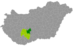 Paks District within Hungary and Tolna County. | |
| Coordinates: 46°36′30″N 18°50′57″E / 46.6084°N 18.8491°ECoordinates: 46°36′30″N 18°50′57″E / 46.6084°N 18.8491°E | |
| Country | |
| County | Tolna |
| District seat | Paks |
| Area | |
| • Total | 836.00 km2 (322.78 sq mi) |
| Area rank | 2nd in Tolna |
| Population (2011 census) | |
| • Total | 49,433 |
| • Rank | 2nd in Tolna |
| • Density | 59/km2 (150/sq mi) |

Paks (Hungarian: Paksi járás) is a district in north-eastern part of Tolna County. Paks is also the name of the town where the district seat is found. The district is located in the Southern Transdanubia Statistical Region.
Geography[]
Paks District borders with Sárbogárd District and Dunaújváros District (Fejér County) to the north, Kunszentmiklós District and Kalocsa District (Bács-Kiskun County) to the east, Tolna District and Szekszárd District to the south, Tamási District to the west. The number of the inhabited places in Paks District is 15.
Municipalities[]
The district has 2 towns, 1 large village and 12 villages. (ordered by population, as of 1 January 2013)[1]
- Bikács (466)
- Bölcske (2,787)
- Dunaföldvár (8,722)
- Dunaszentgyörgy (2,555)
- Gerjen (1,203)
- Györköny (992)
- Kajdacs (1,262)
- Madocsa (1,935)
- Nagydorog (2,591)
- Németkér (1,715)
- Paks (19,481) – district seat
- Pálfa (1,572)
- Pusztahencse (955)
- Sárszentlőrinc (1,078)
- Tengelic (2,296)
The bolded municipalities are cities, italics municipality is large village.
See also[]
- List of cities and towns in Hungary
References[]
- ^ "A KSH 2013. évi helységnévkönyve". ksh.hu. Retrieved 2017-12-26.
External links[]
| Towns (2) |
| |
|---|---|---|
| Large village (1) | ||
| Villages (12) | ||
This Tolna location article is a stub. You can help Wikipedia by . |
- Districts in Tolna County
- Tolna geography stubs