Panmure Basin
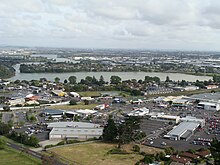

The Panmure Basin (traditionally known in Māori as Kaiahiku[1]), also sometimes known as the Panmure Lagoon, is a tidal estuary within a volcanic crater or maar in New Zealand's Auckland volcanic field, which erupted approximately 25,200 years ago.[2] It is located to the south of Panmure town centre.
In February 2008, scientists announced that drilling had discovered a scoria cone buried within the mud filling the explosion crater.[3] Although newspaper journalists inferred that the discovered scoria cone was a much younger and different volcano from Panmure Basin,[4] geologists consider that the scoria cone was produced as the second phase of the eruption of Panmure Basin explosion crater and tuff ring. The explosive phase was produced by the interaction of the magma with cold groundwater but once the water was used up the eruption switched to a dry phase of fire-fountaining producing the scoria cone from the same vent.[5] Thus Panmure Basin is no different from a number of other volcanoes in the Auckland volcanic field, such as the Auckland Domain Volcano, Mangere Lagoon Volcano, Waitomokia, Te Tatua-a-Riukiuta and Crater Hill (each with one or more scoria cones inside their explosion crater), except that Panmure Basin's small central scoria cone was buried.
References[]
- Volcanoes of Auckland: The Essential guide - Hayward, B.W., Murdoch, G., Maitland, G.; Auckland University Press, 2011.
- Volcanoes of Auckland: A Field Guide. Hayward, B.W.; Auckland University Press, 2019, 335 pp. ISBN 0-582-71784-1.
- ^ Pegman, David M (August 2007). "The Volcanoes of Auckland" (PDF). Manukau City Council. Mangere Mountain Education Centre. Archived from the original (PDF) on 1 December 2020. Retrieved 6 October 2021.
- ^ Hopkins, Jenni L.; Smid, Elaine R.; Eccles, Jennifer D.; Hayes, Josh L.; Hayward, Bruce W.; McGee, Lucy E.; van Wijk, Kasper; Wilson, Thomas M.; Cronin, Shane J.; Leonard, Graham S.; Lindsay, Jan M.; Németh, Karoly; Smith, Ian E. M. (3 July 2021). "Auckland Volcanic Field magmatism, volcanism, and hazard: a review". New Zealand Journal of Geology and Geophysics. 64 (2–3): 213–234. doi:10.1080/00288306.2020.1736102.
- ^ "Geologists find buried volcano inside Panmure Basin". Press release. GNS Science. 22 February 2008. Archived from the original on 1 November 2011. Retrieved 1 November 2011.
- ^ "New Auckland volcano discovered". The New Zealand Herald. NZPA. 22 February 2008. Retrieved 1 November 2011.
- ^ Hayward, B.W., Murdoch, G., Maitland, G. 2011. Volcanoes of Auckland: The essential guide. Auckland University Press.
External links[]
- Photographs of Panmure Basin held in Auckland Libraries' heritage collections.
Coordinates: 36°54′18″S 174°50′58″E / 36.90495°S 174.849343°E


This Auckland Region-related geography article is a stub. You can help Wikipedia by . |
- Auckland volcanic field
- Coastline of New Zealand
- Maars of New Zealand
- Estuaries of New Zealand
- Volcanoes of the Auckland Region
- Auckland Region geography stubs