Parque (Santurce)
Parque | |
|---|---|
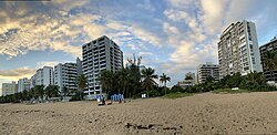 Beach in Parque | |
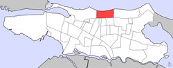 Location of Parque in Santurce (in red) | |
| Coordinates: 18°27′12″N 66°3′34″W / 18.45333°N 66.05944°W | |
| Commonwealth | |
| Municipality | |
| Barrio | Santurce |
| Area | |
| • Total | .36 sq mi (0.9 km2) |
| • Land | .12 sq mi (0.3 km2) |
| • Water | .14 sq mi (0.4 km2) |
| Elevation | 0 ft (0 m) |
| Population (2010) | |
| • Total | 2,871 |
| • Density | 23,925/sq mi (9,237/km2) |
| Source: 2010 Census | |
| Time zone | UTC−4 (AST) |

Parque is one of the forty subbarrios of Santurce, San Juan, Puerto Rico. It is located between Condado and Ocean Park.
Demographics[]
In 2000, Parque had a population of 3,251.[3]
In 2010, Parque had a population of 2,871 and a population density of 23,925 persons per square mile.[1]
Description[]
In the east, the boundary to Ocean Park is formed by Calle María Mozco (northern part) and Calle Santa Ana. In the west, the boundary to Condado is marked by De Diego Avenue and its straight extension towards the Atlantic coast. The boundary runs along but does not include Calle Loíza. In the north is the coast of the Atlantic Ocean.
See also[]
References[]
- ^ a b Puerto Rico 2010 population and housing unit counts.pdf (PDF). U.S. Dept. of Commerce, Economics and Statistics Administration, U.S. Census Bureau. 2010.
- ^ U.S. Geological Survey Geographic Names Information System: Parque Subbarrio
- ^ Puerto Rico 2000: Population and Housing Unit Counts
This San Juan, Puerto Rico location article is a stub. You can help Wikipedia by . |
Categories:
- Santurce, San Juan, Puerto Rico
- Municipality of San Juan
- Puerto Rico Senatorial district I geography stubs