Pavlov (Kladno District)
This article does not cite any sources. (March 2016) |
Pavlov | |
|---|---|
Village | |
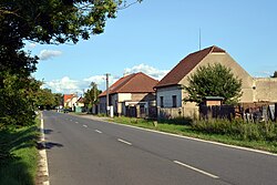 Karlovarská street in Pavlov | |
 Flag  Coat of arms | |
 Pavlov Location in the Czech Republic | |
| Coordinates: 50°05′44″N 14°10′02″E / 50.09556°N 14.16722°ECoordinates: 50°05′44″N 14°10′02″E / 50.09556°N 14.16722°E | |
| Country | Czech Republic |
| Region | Central Bohemian |
| District | Kladno |
| Municipality | Unhošť |
| Founded | 1799 |
| Government | |
| • Mayor | Vojtěch Peichl |
| Area | |
| • Total | 1.55 km2 (0.60 sq mi) |
| Elevation | 387 m (1,270 ft) |
| Population (2006) | |
| • Total | 106 |
| • Density | 68/km2 (180/sq mi) |
| Time zone | UTC+1 (CET) |
| • Summer (DST) | UTC+2 (CEST) |
| Postal code | 273 51 |

Pavlov (Czech pronunciation: [ˈpavlof]) is a small village in Central Bohemian Region of the Czech Republic. It is located in almost flat landscape about 7 km southeast of Kladno or 18 km west of Prague and has a population of 106 (2006).
Main road No. 6 from Prague to Karlovy Vary used to run through the village, there is also a station on railroad No. 120 connecting Prague with Kladno and Rakovník. A new R6 expressway, which passes just north of Pavlov and alleviates it from heavy traffic, was opened in December 2008.
The history of Pavlov is very short in comparison with other settlements in the Czech Republic. There used to be only a small farm with a brewery amidst fields, first mentioned in 1560 and later, after reconstruction in 1726, called Nový Dvůr ("New Farm"). In 1799 a wealthy citizen of Prague named Leopold Paul founded a manor house and a settlement next to the farm and named it after himself Paulhof (in German) or Pavlov (in Czech). The older name Nový Dvůr (or in pluralized form Nové Dvory) was informally also widely used even much later into 20th century.
, a Czech geographer, was born in Pavlov in 1880.
| Wikimedia Commons has media related to Pavlov (Kladno District). |
| Authority control: National libraries |
|---|
- Populated places in Kladno District
- Villages in Kladno District
- Populated places established in 1799
- Kladno geography stubs